Dosiero:Breakup of Yugoslavia.gif
Paĝenhavo ne ekzistas en aliaj lingvoj.
El Vikipedio, la libera enciklopedio

Bildo en pli alta difino((1 545 × 1 242 rastrumeroj, grandeco de dosiero: 187 KB, MIME-tipo: image/gif), ripeta GIF, 14 ĉeloj, 44 s)

Jen dosiero de la Wikimedia-Komunejo. La priskribo en ties priskriba paĝo estas montrata suben.
La Komunejo estas dosieruja retejo de libere licencitaj dosieroj.
This image could be re-created using vector graphics as an SVG file. This has several advantages; see Commons:Media for cleanup for more information. If an SVG form of this image is available, please upload it and afterwards replace this template with {{vector version available|new image name}}. It is recommended to name the SVG file "Breakup of Yugoslavia.svg" - then the template Vector version available (or Vva) does not need the new image name parameter.

Resumo

Key:

Yugoslavia (1943–1992) SFR Yugoslavia
Croatia (1991–present) Croatia
Herzeg-Bosnia (1992–1994)
UNTAES (1996–1998)
Federal Republic of Yugoslavia / Serbia and Montenegro (1992–2006) Serbia and Montenegro
Republika Srpska (1992–present) Republika Srpska
Serbian Krajina (1991–1995/96)
Republic of Bosnia and Herzegovina (1992–1995)
Bosnia and Herzegovina (1998–present) Bosnia and Herzegovina
Western Bosnia (1993–1995)
Serbia (2006–present) Serbia
Kosovo (under UNMIK control 1999–present; declaration of independence 2008) Kosovo
Montenegro (2006–present) Montenegro
Macedonia (1991–present) Macedonia
Slovenia (1991–present) Slovenia


Priskribo

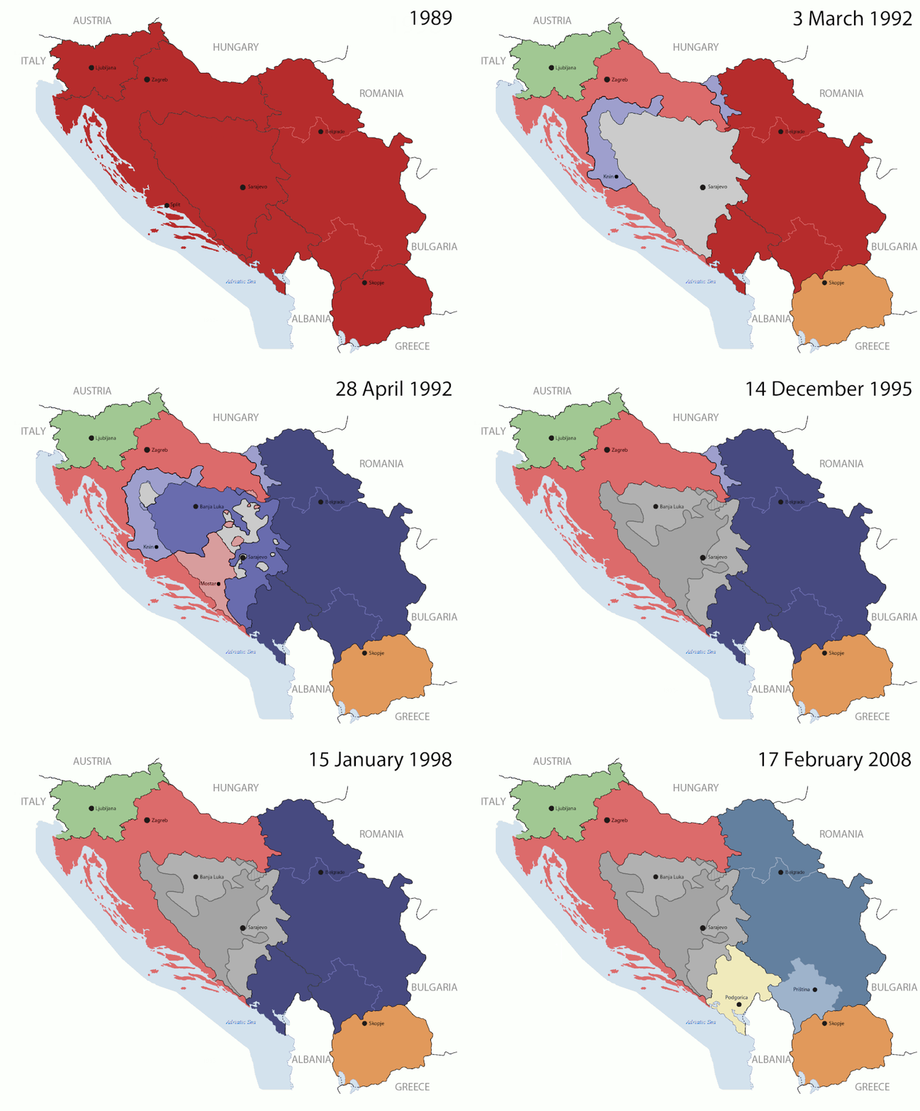
This is an animated GIF that shows the stages of the breakup of the SFR Yugoslavia in the 90's and 2000's. The map based off Morwen's map of the divisions of the SFRY, Which is licensed by the GFDL. The source for the dates of independence is the CIA World Factbook. These maps do not now show the Inter-Entity Boundary Line (IEBL) and/or the entities that are separated by it. The IEBL has been drawn based on this CIA map; the Brčko District has been drawn based on Image:BH municipality location.gif, by user:Ante Perkovic. I might add them in the future.

Since the original map was GFDL, this image is as well.

A map depicting Kosovo's final status is ready once it takes effect.


Changelog for versions 2/3:

Here are some changes in this new build of the map:

  • The Kosovo boundary has been given a shade of red instead of the previous UN blue since they are a province of Serbia under UNIMIK control.
  • Montenegro's color has been changed to a golden shade close to what's on the flag.
  • The IEBL and the Brčko District has been redrawn because I deleted the original map; the color for the Republika Srpska is lighter.
  • The dates are at the top left hand corner of the map instead of the bottom.
  • I have taken a new approach as to the boundaries. Each part of Yugoslavia now shows the boundary on the maps starting the year they broke away. I feel this change helps readers understand the breakup better.
  • The SFRY and the FRY are in different shades since the FRY was never accepted as the successor to the former by the UN.
  • The colors for the entities of BiH have been removed as to not confuse people into thinking that they are independent states. What remains is the IEBL with both entities in green.
  • The Kosovo boundary is finally in hash marks!
  • The Brčko District has been removed. The sale is too small to show accurately.

Changelog for version 4:

  • The map is larger!
  • The image has been rebuilt to include the eastern part of FYR Macedonia.
  • The image has been updated to take in Kosovo's new status.
  • The IEBL is now a darker line.
  • Montenegro, Kosovo, and FRY/SCG/Serbia have new colors!

Changelog for version 5:

  • Rebuilt
  • Larger map: size of base image
  • Accurate Inter-Entity Boundary Line
Dato 24 July 2006 (orginal upload date)
Fonto Made by Hoshie; see above for more details on sources.
Aŭtoro Hoshie
Ceteraj versioj

Permesiloj:

GNU head Estas permesite kopii, disdoni kaj/aŭ redakti ĉi tiun dokumenton, sen senŝanĝaj sekcioj, sen antaŭkovrilaj kaj sen dorskovrilaj tekstoj, laŭ la kondiĉoj de la Permesilo GNU por Liberaj Dokumentoj, Versio 1.2 aŭ ajna pli nova versio eldonita de la Free Software Foundation; sen Senŝanĝaj Sekcioj, Antaŭovrilaj Tekstoj aŭ Malantaŭkovrilaj Tekstoj. Kopio de la permesilo estas inkluzivita en la sekcio titolita GNU Free Documentation License.
w:eo:Creative Commons
atribuite samkondiĉe
Ĉi tiu dosiero estas disponebla laŭ la permesilo Krea Komunaĵo Atribuite-Samkondiĉe 3.0 Neadaptita.
Vi rajtas:
  • kunhavigi – kopii, distribui kaj publikigi la verkon
  • aliigi – modifi, adapti, kompletigi, transformi, uzi la tutan verkon aŭ ties partojn, memstare aŭ en aliaj verkoj
La verko rajtas esti kunhavigata nur:
  • atribuite – Vi devas atribui aŭtorecon, liveri ligilon al la permesilo kaj marki ĉu ŝanĝoj estis faritaj. Faru tion en aprobinda maniero, tamen ne sugestante, ke permesinto aprobas vin aŭ vian uzon.
  • samkondiĉe – Se vi rekombinas la verkon, transformas ĝin aŭ kreas devenaĵon bazitan sur ĝi, vi rajtas distribui la rezultan verkon nur laŭ la sama aŭ kongrua permesilo kompare kun ĉi tiu.
Ĉi tiu permesila etikedo estis aldonita al la dosiero kiel parto de la permesila aktualigo por GFDL.

Titoloj

Donu unulinian priskribon de la enhavo de ĉi tiu dosiero

Eroj prezentitaj en ĉi tiu dosiero

montras

image/gif

05ca2aefea8406b809968643552d5095c847a42f

191 625 bajto

44 sekundo

1 242 rastrumero

1 545 rastrumero

Dosierhistorio

Alklaku iun daton kaj horon por vidi kiel la dosiero tiam aspektis.

(plej lasta | plej frua) Montri (pli novajn 10 | ) (10 | 20 | 50 | 100 | 250 | 500)
Dato/HoroBildetoGrandecojUzantoKomento
nun07:40, 17 jul. 2016Bildeto por versio ekde 07:40, 17 jul. 20161 545 × 1 242 (187 KB)מפתח-רשימהReverted to version as of 17:22, 21 August 2015 (UTC)
17:22, 21 aŭg. 2015Bildeto por versio ekde 17:22, 21 aŭg. 20151 463 × 1 158 (1,81 MB)BraganzaReverted to version as of 03:57, 19 January 2010
17:22, 21 aŭg. 2015Bildeto por versio ekde 17:22, 21 aŭg. 20151 545 × 1 242 (187 KB)BraganzaReverted to version as of 01:02, 19 December 2011
17:15, 21 aŭg. 2015Bildeto por versio ekde 17:15, 21 aŭg. 2015120 × 95 (3 KB)Braganza03:57, 19. Jan. 2010
01:02, 19 dec. 2011Bildeto por versio ekde 01:02, 19 dec. 20111 545 × 1 242 (187 KB)DIREKTORAdded details
18:09, 27 jul. 2011Bildeto por versio ekde 18:09, 27 jul. 20111 545 × 1 242 (170 KB)DIREKTORSmall fixes
17:28, 27 jul. 2011Bildeto por versio ekde 17:28, 27 jul. 20111 545 × 1 242 (171 KB)DIREKTORAdded UNMIK
16:38, 27 jul. 2011Bildeto por versio ekde 16:38, 27 jul. 20111 545 × 1 242 (165 KB)DIREKTORDates for the last two frames.
12:10, 27 jul. 2011Bildeto por versio ekde 12:10, 27 jul. 20111 545 × 1 242 (149 KB)DIREKTORLighter shade for country names
16:59, 26 jul. 2011Bildeto por versio ekde 16:59, 26 jul. 20111 545 × 1 242 (170 KB)DIREKTORHigher res plus details
(plej lasta | plej frua) Montri (pli novajn 10 | ) (10 | 20 | 50 | 100 | 250 | 500)

La jenaj paĝoj ligas al ĉi tiu dosiero:

Suma uzado de la dosiero

La jenaj aliaj vikioj utiligas ĉi tiun dosieron:

Vidi plian ĝeneralan uzadon de ĉi tiu dosiero.

Metadatumoj