
Dosiero:Chatham Islands from space ISS005-E-15265.jpg
Grandeco de ĉi antaŭvido: 599 × 599 rastrumeroj. Aliaj distingivoj: 240 × 240 rastrumeroj | 480 × 480 rastrumeroj | 768 × 768 rastrumeroj | 1 023 × 1 024 rastrumeroj | 1 631 × 1 632 rastrumeroj.
Bildo en pli alta difino ((1 631 × 1 632 rastrumeroj, grandeco de dosiero: 365 KB, MIME-tipo: image/jpeg))
| Jen dosiero de la Wikimedia-Komunejo. La priskribo en ties priskriba paĝo estas montrata suben.
|
== Resumo ==NASA GOV
| Priskribo |
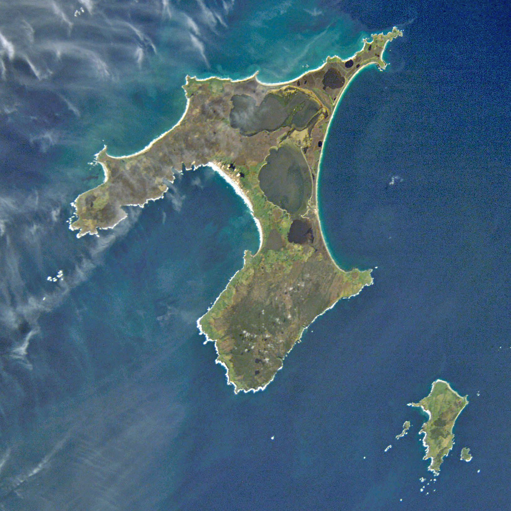
English: NASA astronaut image of Chatham Islands, New Zealand, in the Pacific Ocean. North is up.
Deutsch: NASA-Astronautenbild der Chatham-Inseln, Neuseeland, im Pazifischen Ozean
Français : Image satellite de la NASA montrant les îles Chatham, dans l'océan Pacifique. Orientée nord.
|
||||||||||||||||||||||||||||||||||||||||||||||||||
| Dato | |||||||||||||||||||||||||||||||||||||||||||||||||||
| Fonto | http://eol.jsc.nasa.gov/scripts/sseop/QuickView.pl?directory=ESC&ID=ISS005-E-15265 | ||||||||||||||||||||||||||||||||||||||||||||||||||
| Aŭtoro | NASA | ||||||||||||||||||||||||||||||||||||||||||||||||||
| Permeso (Reuzo de la dosiero) |
Conditions of Use of Astronaut Photographs | ||||||||||||||||||||||||||||||||||||||||||||||||||
| Pozicio de la fotilo | | Tiu cxi bildo kaj pliaj sur OpenStreetMap |
|---|
This image or video was catalogued by Johnson Space Center of the United States National Aeronautics and Space Administration (NASA) under Photo ID: ISS005-E-15265. This tag does not indicate the copyright status of the attached work. A normal copyright tag is still required. See Commons:Licensing. Other languages:
|
| Ĉi tio estas modifita bildo, kio signifas, ke ĝi ekestis per cifereca aliigo de la origina versio. Modifoj: cropped.
|
Permesiloj:
This file is in the public domain in the United States because it was created by the Image Science & Analysis Laboratory, of the NASA Johnson Space Center. NASA copyright policy states that "NASA material is not protected by copyright unless noted". (NASA media use guidelines or Conditions of Use of Astronaut Photographs).
Photo source: ISS005-E-15265.
|

|
This image has been assessed under the valued image criteria and is considered the most valued image on Commons within the scope: Satellite picture of the Chatham Islands. You can see its nomination here. |
Dosierhistorio
Alklaku iun daton kaj horon por vidi kiel la dosiero tiam aspektis.
| Dato/Horo | Bildeto | Grandecoj | Uzanto | Komento | |
|---|---|---|---|---|---|
| nun | 20:02, 13 apr. 2011 | | 1 631 × 1 632 (365 KB) | Alexrk2 | digitally enhanced |
| 04:46, 17 sep. 2005 |  | 1 631 × 1 632 (269 KB) | Zeimusu | Chatham Islands, photo taken by Astronaut aboard the ISS Based on Public Domain image from Nasa. Earth Sciences and Image Analysis, NASA-Johnson Space Center. 24 Sep. 2003. "Astronaut Photography of Earth - Quick View." http://eol.jsc.nasa.gov/scripts/s |
Dosiera uzado
La jenaj paĝoj ligas al ĉi tiu dosiero:
Suma uzado de la dosiero
La jenaj aliaj vikioj utiligas ĉi tiun dosieron:
- Uzado en af.wikipedia.org
- Uzado en ar.wikipedia.org
- Uzado en az.wikipedia.org
- Uzado en be.wikipedia.org
- Uzado en bn.wikipedia.org
- Uzado en br.wikipedia.org
- Uzado en ca.wikipedia.org
- Uzado en ceb.wikipedia.org
- Uzado en cs.wikipedia.org
- Uzado en da.wikipedia.org
- Uzado en de.wikipedia.org
- Uzado en el.wikipedia.org
- Uzado en en.wikipedia.org
- Uzado en en.wikivoyage.org
- Uzado en es.wikipedia.org
- Uzado en fa.wikipedia.org
- Uzado en fr.wikipedia.org
- Uzado en fr.wiktionary.org
- Uzado en gl.wikipedia.org
- Uzado en he.wikipedia.org
- Uzado en hr.wikipedia.org
- Uzado en hu.wikipedia.org
- Uzado en hy.wikipedia.org
- Uzado en id.wikipedia.org
- Uzado en it.wikipedia.org
- Uzado en ja.wikipedia.org
Vidi plian ĝeneralan uzadon de ĉi tiu dosiero.