
Dosiero:Cuban crisis map missile range.jpg
Grandeco de ĉi antaŭvido: 603 × 599 rastrumeroj. Aliaj distingivoj: 241 × 240 rastrumeroj | 483 × 480 rastrumeroj | 666 × 662 rastrumeroj.
Bildo en pli alta difino ((666 × 662 rastrumeroj, grandeco de dosiero: 198 KB, MIME-tipo: image/jpeg))
| Jen dosiero de la Wikimedia-Komunejo. La priskribo en ties priskriba paĝo estas montrata suben.
|

|
Ĉi tiu dosiero estas anstataŭigita per File:The relative ranges of the IL-28, SS-4, and SS-5, stationed on Cuba.png. Prefere uzu tiun alian dosieron. Kialo: A PNG version of this file is now available.
|

|
| Priskribo |
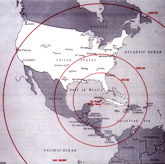
English: Map of Northern America showing the full range of the nuclear missiles under construction in Cuba, used during the secret meetings on the Cuban crisis. Deutsch: Diese Karte der westlichen Hemisphäre zeigt die volle Reichweite der Atomraketen, die auf Kuba im Rahmen der Kubakrise stationiert werden sollten bzw. worden sind. Diese Karte wurde bei den geheimen Treffen während der Kubakrise verwendet. Die Karte war ehemals Top Secret. Die eingezeichneten Radien sind in Nautischen Meilen (1 NM ~ 1,852 km) bemaßt; die 1020 NM (~ 1900 km) entsprechen ungefähr der taktischen Reichweite der SS-4, die 2200 NM (~ 4000 km) jener der SS-5. |
|||
| Dato | ||||
| Fonto | The John F. Kennedy Presidential Library and Museum, Boston. [1] | |||
| Aŭtoro | CIA | |||
| Permeso (Reuzo de la dosiero) |
|

![[1]](http://www.jfklibrary.org/jfkl/cmc/cmc_map_missile_range.jpg)
Dosierhistorio
Alklaku iun daton kaj horon por vidi kiel la dosiero tiam aspektis.
| Dato/Horo | Bildeto | Grandecoj | Uzanto | Komento | |
|---|---|---|---|---|---|
| nun | 21:18, 8 jan. 2009 | | 666 × 662 (198 KB) | PaulBommel | {{Information |Description= |Source= |Date= |Author= |Permission= |other_versions= }} |
| 16:31, 9 jun. 2007 |  | 700 × 920 (249 KB) | Nickel Chromo~commonswiki | {{Information| |Description= '''English''': Map of the western hemisphere showing the full range of the nuclear missiles under construction in Cuba, used during the secret meetings on the Cuban crisis. |Source= The John F. Kennedy Presidential Library and |
Dosiera uzado
La jena paĝo ligas al ĉi tiu dosiero:
Suma uzado de la dosiero
La jenaj aliaj vikioj utiligas ĉi tiun dosieron:
- Uzado en ar.wikipedia.org
- Uzado en ba.wikipedia.org
- Uzado en bg.wikipedia.org
- Uzado en da.wikipedia.org
- Uzado en en.wikipedia.org
- Uzado en en.wikiquote.org
- Uzado en es.wikipedia.org
- Uzado en fi.wikipedia.org
- Uzado en fi.wikibooks.org
- Uzado en ga.wikipedia.org
- Uzado en hr.wikipedia.org
- Uzado en it.wikipedia.org
- Uzado en lv.wikipedia.org
- Uzado en no.wikibooks.org
- Uzado en rm.wikipedia.org
- Uzado en ro.wikipedia.org
- Uzado en ru.wikipedia.org
- Uzado en sr.wikipedia.org
- Uzado en sv.wikipedia.org
- Uzado en th.wikipedia.org
- Uzado en uk.wikipedia.org