
Dosiero:Haiti earthquake damage overhead.jpg

Grandeco de ĉi antaŭvido: 800 × 532 rastrumeroj. Aliaj distingivoj: 320 × 213 rastrumeroj | 640 × 426 rastrumeroj | 1 024 × 681 rastrumeroj | 1 280 × 852 rastrumeroj | 2 560 × 1 703 rastrumeroj | 4 256 × 2 832 rastrumeroj.
Bildo en pli alta difino ((4 256 × 2 832 rastrumeroj, grandeco de dosiero: 2,14 MB, MIME-tipo: image/jpeg))
| Jen dosiero de la Wikimedia-Komunejo. La priskribo en ties priskriba paĝo estas montrata suben.
|
Resumo
| Priskribo |
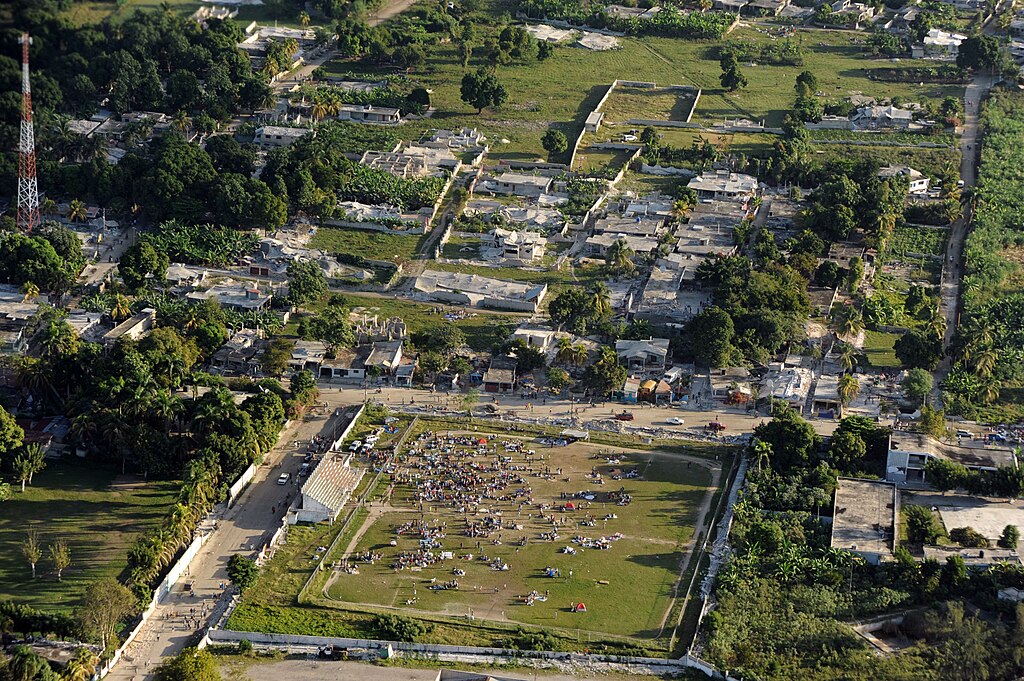
English: CLEARWATER, Fla. – A Coast Guard C-130 Hercules fixed-wing aircraft crew from Air Station Clearwater, conducts an overflight assessment above Port-au-Prince, Haiti, January 13, 2010. The assessment follows a 7.0 magnitude earthquake that damaged the region January 12, 2010. (Text from USCG.) However this image shows a place [1] in Léogâne.
Deutsch: CLEARWATER, Fla. – Die Besatzung einer Hercules C-130 der United States Coast Guard vom Stützpunkt Clearwater haben am 13. Januar 2010 eine Überfliegung von Port-au-Prince, Haiti zur Abschätzung der Schäden durchgeführt. Der Einschätzungsflug fand nach einem Erdbeben der Stärke 7.0 statt, dass die Region am 12. Januar 2010 schädigte. (Freie Übersetzung des englischen Bildkommentars der USCG.) Das Bild hier zeigt jedoch einen ehemaliges Sportfeld und Gebäudeschäden in Léogâne (OpenStreetMap-Link).
Suomi: Yhdysvaltain rannikkovartioston C-130 Hercules -lentokoneesta otettu ilmakuva Port-au-Princesta, Haitista, 12. tammikuuta 2010 sattuneen maanjäristyksen jälkeen. |
|||
| Dato | ||||
| Fonto |
|
|||
| Aŭtoro | U.S. Coast Guard photo by Petty Officer 2nd Class Sondra-Kay Kneen |

| Pozicio de la objekto | | Tiu cxi bildo kaj pliaj sur OpenStreetMap |
|---|
Permesiloj:
This image or file is a work of a United States Coast Guard service personnel or employee, taken or made as part of that person's official duties. As a work of the U.S. federal government, the image or file is in the public domain (17 U.S.C. § 101 and § 105, USCG main privacy policy and specific privacy policy for its imagery server).
|
 |
Dosierhistorio
Alklaku iun daton kaj horon por vidi kiel la dosiero tiam aspektis.
| Dato/Horo | Bildeto | Grandecoj | Uzanto | Komento | |
|---|---|---|---|---|---|
| nun | 07:26, 14 jan. 2010 | | 4 256 × 2 832 (2,14 MB) | Botev | full resolution |
| 02:47, 14 jan. 2010 |  | 500 × 333 (345 KB) | PAVA11 | {{Information |Description={{en|1=CLEARWATER, Fla. - A Coast Guard C-130 Hercules fixed-wing aircraft crew from Air Station Clearwater, conducts an overflight assessment above Port-au-Prince, Haiti, January 13, 2009. The assessment follows a 7.0 magnitude |
Dosiera uzado
La jena paĝo ligas al ĉi tiu dosiero:
Suma uzado de la dosiero
La jenaj aliaj vikioj utiligas ĉi tiun dosieron:
- Uzado en az.wikipedia.org
- Uzado en cs.wikipedia.org
- Uzado en de.wikipedia.org
- Uzado en el.wikipedia.org
- Uzado en en.wikipedia.org
- Uzado en en.wikinews.org
- Uzado en et.wikipedia.org
- Uzado en fr.wikipedia.org
- Uzado en hr.wikipedia.org
- Uzado en ht.wikipedia.org
- Uzado en hu.wikipedia.org
- Uzado en id.wikipedia.org
- Uzado en ja.wikipedia.org
- Uzado en ki.wikipedia.org
- Uzado en mk.wikipedia.org
- Uzado en no.wikipedia.org
- Uzado en nv.wikipedia.org
- Uzado en pl.wikinews.org
- Uzado en pt.wikipedia.org
- Uzado en ro.wikipedia.org
- Uzado en ro.wikinews.org
- Uzado en ru.wikipedia.org
- Uzado en ru.wikinews.org
- Uzado en sh.wikipedia.org
- Uzado en sq.wikipedia.org
- Uzado en ta.wikipedia.org
- Uzado en ta.wikinews.org
- Uzado en tr.wikipedia.org
- Uzado en tr.wikinews.org
- Uzado en uk.wikipedia.org
- Uzado en www.wikidata.org