
Dosiero:RIBay.JPG
Grandeco de ĉi antaŭvido: 405 × 600 rastrumeroj. Aliaj distingivoj: 162 × 240 rastrumeroj | 324 × 480 rastrumeroj | 691 × 1 023 rastrumeroj.
Bildo en pli alta difino ((691 × 1 023 rastrumeroj, grandeco de dosiero: 425 KB, MIME-tipo: image/jpeg))
| Jen dosiero de la Wikimedia-Komunejo. La priskribo en ties priskriba paĝo estas montrata suben.
|
Resumo
| Priskribo |
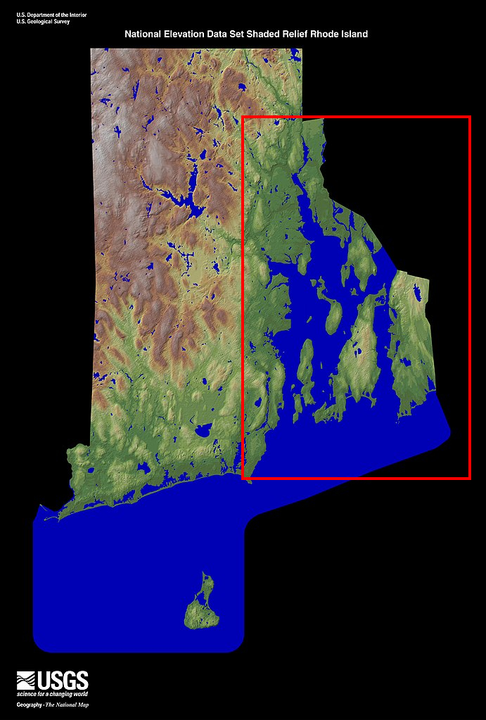
English: Shaded relief map of the state of en:Rhode Island with en:Narragansett Bay in red.. From the United States Geological Survey (USGS) |
| Fonto | http://edc.usgs.gov/imagegallery/collection.php?col=States+-+NED+Shaded+Relief Edited from en:Image:Rhode Island - NED500.jpg |
| Aŭtoro |
Permesiloj:
This image is in the public domain in the United States because it only contains materials that originally came from the United States Geological Survey, an agency of the United States Department of the Interior. For more information, see the official USGS copyright policy.
|
Originala alŝutada protokolo
The original description page was here. All following user names refer to en.wikipedia.
- 2007-12-19 16:10 Loodog 337×500×8 (33046 bytes) Shaded relief map of the state of [[Rhode Island]] with [[Narragansett Bay]] in red.. From the United States Geological Survey (USGS) Source: http://edc.usgs.gov/imagegallery/collection.php?col=States+-+NED+Shaded+Relief Edited from [[Image
Dosierhistorio
Alklaku iun daton kaj horon por vidi kiel la dosiero tiam aspektis.
| Dato/Horo | Bildeto | Grandecoj | Uzanto | Komento | |
|---|---|---|---|---|---|
| nun | 03:49, 13 jan. 2022 | | 691 × 1 023 (425 KB) | Usename9886 | Higher resolution version |
| 21:47, 12 mar. 2008 |  | 337 × 500 (32 KB) | File Upload Bot (Magnus Manske) | {{BotMoveToCommons|en.wikipedia}} {{Information |Description={{en|Shaded relief map of the state of en:Rhode Island with en:Narragansett Bay in red.. From the United States Geological Survey (USGS) Source: http://edc.usgs.gov/imagegallery/colle |
Dosiera uzado
La jena paĝo ligas al ĉi tiu dosiero:
Suma uzado de la dosiero
La jenaj aliaj vikioj utiligas ĉi tiun dosieron:
- Uzado en de.wikipedia.org
- Uzado en en.wikipedia.org
- Uzado en es.wikipedia.org
- Uzado en fr.wikipedia.org
- Uzado en id.wikipedia.org
- Uzado en it.wikipedia.org
- Uzado en nl.wikipedia.org
- Uzado en pl.wikipedia.org
- Uzado en pt.wikipedia.org
- Uzado en ru.wikipedia.org
- Uzado en th.wikipedia.org
- Uzado en tr.wikipedia.org
- Uzado en uk.wikipedia.org
- Uzado en vi.wikipedia.org
- Uzado en zh.wikipedia.org