
Dosiero:ShepherdByzempire1265.jpg
Bildo en pli alta difino ((1 144 × 900 rastrumeroj, grandeco de dosiero: 281 KB, MIME-tipo: image/jpeg))
| Jen dosiero de la Wikimedia-Komunejo. La priskribo en ties priskriba paĝo estas montrata suben.
|
Resumo
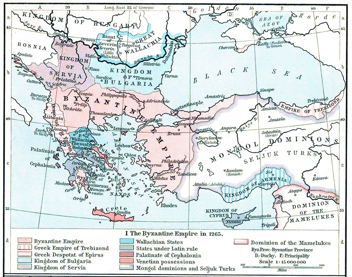
| Priskribo | Map, The Byzantine Empire, 1265. | ||||||||||||||||||||||
| Dato | |||||||||||||||||||||||
| Fonto | The Historical Atlas, William R. Shepherd, 1911. | ||||||||||||||||||||||
| Aŭtoro |
|
||||||||||||||||||||||
| Ceteraj versioj |
Derivaĵoj de ĉi tiu dosiero: |
||||||||||||||||||||||

|
Tiu ĉi bildo old map respektive ĉiuj bildoj en tiu ĉi artikolo aŭ kategorio prefere estu rekreata(j) kiel vektora grafikaĵo en la formato SVG. Vektoraj formatoj por grafikaĵoj havas multajn avantaĝojn, detaloj troveblas anglalingve en la komuneja artikolo Commons:Media for cleanup. Se vi havas aŭ kreas SVG-version de tiu ĉi bildo, bonvolu alŝuti ĝin al la vikipedia komunejo. Post tiu ago, ĉi tiu ŝablono en la bildpaĝo estas anstataŭigenda per la ŝablono {{vector version available|nova dosiera nomo.svg}}.
|


Permesiloj:
|
Tiu ĉi verko estas publika havaĵo en tiuj landoj, kies kopirajtado validas por longo de vivo plus 70 jaroj aŭ malpli.
| |
| Estis konkludite ke uzon de ĉi tiu dosiero limigas neniu konata aŭtorrajta leĝo, kio inkluzivas ĉiujn rilatajn kaj apudajn rajtojn. | |
This media file is in the public domain in the United States. This applies to U.S. works where the copyright has expired, often because its first publication occurred prior to January 1, 1929, and if not then due to lack of notice or renewal. See this page for further explanation.
|
 | |
 |
This image might not be in the public domain outside of the United States; this especially applies in the countries and areas that do not apply the rule of the shorter term for US works, such as Canada, Mainland China (not Hong Kong or Macao), Germany, Mexico, and Switzerland. The creator and year of publication are essential information and must be provided. See Wikipedia:Public domain and Wikipedia:Copyrights for more details.
|
Dosierhistorio
Alklaku iun daton kaj horon por vidi kiel la dosiero tiam aspektis.
| Dato/Horo | Bildeto | Grandecoj | Uzanto | Komento | |
|---|---|---|---|---|---|
| nun | 15:28, 16 nov. 2022 | | 1 144 × 900 (281 KB) | Gyalu22 | Reverted to version as of 16:26, 12 July 2009 (UTC) |
| 14:49, 20 maj. 2016 |  | 1 144 × 900 (858 KB) | Julieta39 | Cosmetic (see discussion file) | |
| 16:26, 12 jul. 2009 |  | 1 144 × 900 (281 KB) | Alex:D | whitened | |
| 16:17, 12 jul. 2009 |  | 1 144 × 900 (281 KB) | Alex:D | whitened | |
| 16:12, 12 jul. 2009 |  | 1 144 × 900 (281 KB) | Alex:D | whitened | |
| 13:40, 21 dec. 2004 |  | 1 144 × 900 (272 KB) | Mschlindwein | Map, The Byzantine Empire, 1265. The Historical Atlas, William R. Shepherd, 1911. |
Dosiera uzado
La jenaj paĝoj ligas al ĉi tiu dosiero:
Suma uzado de la dosiero
La jenaj aliaj vikioj utiligas ĉi tiun dosieron:
- Uzado en an.wikipedia.org
- Uzado en ar.wikipedia.org
- Uzado en azb.wikipedia.org
- Uzado en az.wikipedia.org
- Uzado en be-tarask.wikipedia.org
- Uzado en be.wikipedia.org
- Uzado en bg.wikipedia.org
- Uzado en ca.wikipedia.org
- Uzado en cs.wikipedia.org
- Uzado en de.wikipedia.org
- Uzado en el.wikipedia.org
- Uzado en en.wikipedia.org
Vidi plian ĝeneralan uzadon de ĉi tiu dosiero.