
Dosiero:Tavush.svg

Grando de tiu PNG antaŭprezento de tiu SVGa dosiero: 587 × 599 rastrumeroj. Aliaj distingivoj: 235 × 240 rastrumeroj | 470 × 480 rastrumeroj | 752 × 768 rastrumeroj | 1 003 × 1 024 rastrumeroj | 2 006 × 2 048 rastrumeroj | 725 × 740 rastrumeroj.
Bildo en pli alta difino (SVG-dosiero, 725 × 740 rastrumeroj, grandeco de dosiero: 72 KB)
| Jen dosiero de la Wikimedia-Komunejo. La priskribo en ties priskriba paĝo estas montrata suben.
|
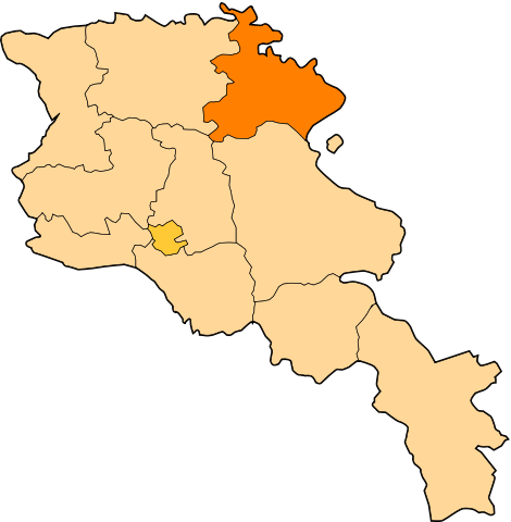
| Priskribo | Image shows the eleven administrative subdivisions of Armenia: # Aragatsotn (Արագածոտնի) # Ararat (Արարատի) # Armavir (Արմավիրի) # Gegharkunik (Գեղարքունիքի) # Kotayk (Կոտայքի) # Lori (Լոռու) # Shirak (Շիրակի) # Syunik (Սյունիքի) # Tavush (Տավուշի) # Vayots Dzor (Վայոց Ձորի) # Yerevan (Երևան) - special administrative status Derived from a multiple of public sources and created using Inkscape. == |
| Dato | (UTC) |
| Fonto | |
| Aŭtoro |
|
| Ĉi tio estas modifita bildo, kio signifas, ke ĝi ekestis per cifereca aliigo de la origina versio. Modifoj: Creation d'une autre map. La originaĵo videblas ĉi tie: Armenia map numbered.svg. La modifojn faris Varmin.
|
Ĉi tiu dosiero estas disponebla laŭ la permesilo Krea Komunaĵo Atribuite-Samkondiĉe 3.0 Neadaptita.
- Vi rajtas:
- kunhavigi – kopii, distribui kaj publikigi la verkon
- aliigi – modifi, adapti, kompletigi, transformi, uzi la tutan verkon aŭ ties partojn, memstare aŭ en aliaj verkoj
- La verko rajtas esti kunhavigata nur:
- atribuite – Vi devas atribui aŭtorecon, liveri ligilon al la permesilo kaj marki ĉu ŝanĝoj estis faritaj. Faru tion en aprobinda maniero, tamen ne sugestante, ke permesinto aprobas vin aŭ vian uzon.
- samkondiĉe – Se vi rekombinas la verkon, transformas ĝin aŭ kreas devenaĵon bazitan sur ĝi, vi rajtas distribui la rezultan verkon nur laŭ la sama aŭ kongrua permesilo kompare kun ĉi tiu.
Originala alŝutada protokolo
This image is a derivative work of the following images:
- File:Armenia_map_numbered.svg licensed with Cc-by-sa-3.0-migrated, GFDL
- 2010-09-26T17:27:10Z 6AND5 725x740 (82221 Bytes) Reverted to version as of 17:31, 25 November 2006 (((Exclaves deleted according to official map at http://www.gov.am/en/regions/)))
- 2006-11-25T19:37:43Z Bastique 725x740 (87638 Bytes) Cleanup
- 2006-11-25T19:26:57Z Bastique 725x740 (86083 Bytes) Enclaves
- 2006-11-25T17:31:38Z Bastique 725x740 (82221 Bytes) Fixed canvas size
- 2006-11-25T17:27:59Z Bastique 744x1052 (79767 Bytes) Image shows the subdivisions of Armenia. Derived from a multiple of public sources and created using Inkscape. == Licensing == {{GFDL}} Image shows the eleven administrative subdivisions of Armenia: #[[Aragatsotn]] (Ար�
Uploaded with derivativeFX
Dosierhistorio
Alklaku iun daton kaj horon por vidi kiel la dosiero tiam aspektis.
| Dato/Horo | Bildeto | Grandecoj | Uzanto | Komento | |
|---|---|---|---|---|---|
| nun | 12:24, 30 dec. 2010 | | 725 × 740 (72 KB) | Varmin | {{Information |Description=Image shows the eleven administrative subdivisions of Armenia: # Aragatsotn (Արագածոտնի) # Ararat (Արարատի) # Armavir (Արմավիրի) # Gegharkunik (Գեղ |
Dosiera uzado
Neniu paĝo ligas al ĉi tiu dosiero.
Suma uzado de la dosiero
La jenaj aliaj vikioj utiligas ĉi tiun dosieron:
- Uzado en ar.wikipedia.org
- Uzado en be.wikipedia.org
- Uzado en bg.wikipedia.org
- Uzado en ceb.wikipedia.org
- Uzado en ce.wikipedia.org
Vidi plian ĝeneralan uzadon de ĉi tiu dosiero.