
Dosiero:Tonlesap.jpg
Grandeco de ĉi antaŭvido: 597 × 599 rastrumeroj. Aliaj distingivoj: 239 × 240 rastrumeroj | 478 × 480 rastrumeroj | 765 × 768 rastrumeroj | 1 020 × 1 024 rastrumeroj | 2 039 × 2 048 rastrumeroj | 4 079 × 4 096 rastrumeroj.
Bildo en pli alta difino ((4 079 × 4 096 rastrumeroj, grandeco de dosiero: 17,17 MB, MIME-tipo: image/jpeg))
| Jen dosiero de la Wikimedia-Komunejo. La priskribo en ties priskriba paĝo estas montrata suben.
|
| Priskribo |
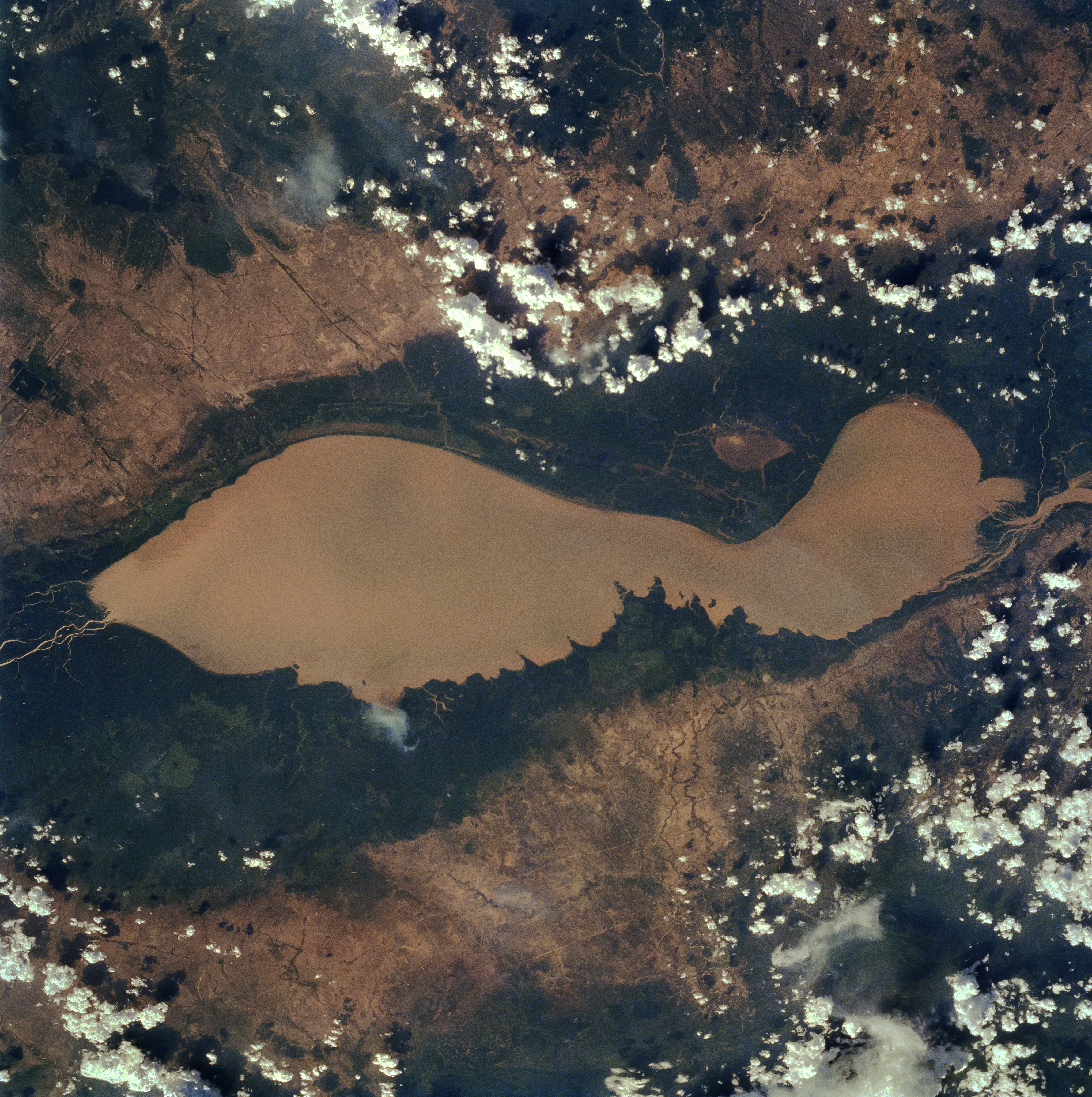
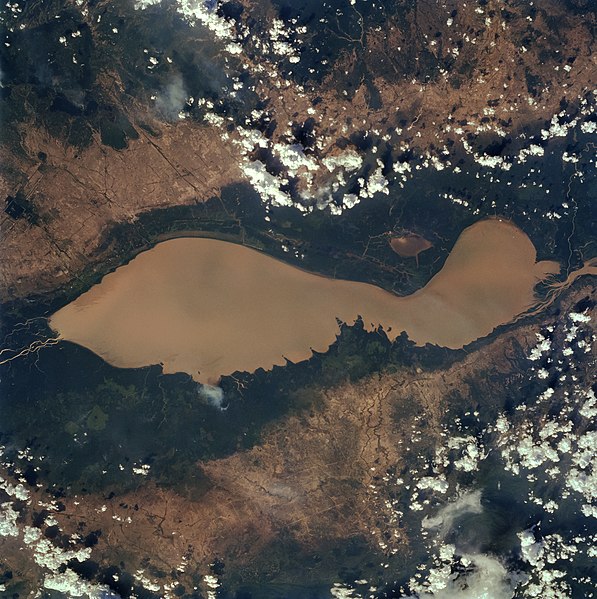
English: The Tonle Sap (also know as the Great Lake) occupies a depression in the Cambodian Plain and is a shallow silt-laden lake. It is the largest lake in Southeast Asia and is fed by many streams. The Tonle Sap is drained by the Tonle Sab River (upper center), which flows south-southeast to the Mekong River (not visible on the image). The river connecting the Tonle Sap with the Mekong creates a unique phenomenon not known in any other part of the world: reversing its direction of flow twice a year. For most of the time, the Tonle Sab River flows from the lake to the Mekong River near the capital city of Phnom Penh. However, during the Southeast Asian monsoon season from June to November, when the Mekong drains large areas of Southeast Asia, the Tonle Sab flows from the Mekong back into the Tonle Sap. During the monsoon season, the Tonle Sap increases from 1000 sq. miles (2600 sq. km) to near 4020 sq. miles (10400 sq. km) raising the lake level 30 feet (9 meters), causing enormous floods in the region surrounding the lake. |
| Dato | |
| Fonto |
Earth from Space - Image Information Gateway to Astronaut Photography of Earth |
| Aŭtoro | NASA/Johnson Space Center |
| Permeso (Reuzo de la dosiero) |
PD-USGov-NASA |
This image or video was catalogued by one of the centers of the United States National Aeronautics and Space Administration (NASA) under Photo ID: STS059-84-80. This tag does not indicate the copyright status of the attached work. A normal copyright tag is still required. See Commons:Licensing. Other languages:
|
| La ĉi-supra dosiero estas publika havaĵo, ĉar ĝi apartenas al NASA. La kopirajta regularo de NASA asertas, ke "ĉiuj dokumentoj de NASA estas publika havaĵo, se ne estas donata kontraŭa deklaro". | ||
 |
Atentu:
|
Dosierhistorio
Alklaku iun daton kaj horon por vidi kiel la dosiero tiam aspektis.
| Dato/Horo | Bildeto | Grandecoj | Uzanto | Komento | |
|---|---|---|---|---|---|
| nun | 10:40, 4 apr. 2022 | | 4 079 × 4 096 (17,17 MB) | Tiouraren | larger version |
| 06:48, 15 jul. 2015 |  | 902 × 695 (293 KB) | Wikirictor | i re-sized it, enhanced its quality and rotated it in order to have north on top. | |
| 05:04, 18 jun. 2006 |  | 637 × 640 (53 KB) | Georgio~commonswiki | {{Information |Description=Earth Sciences and Image Analysis, NASA-Johnson Space Center. 16 Apr. 2004. "Earth from Space - Image Information." |Source=http://earth.jsc.nasa.gov/sseop/efs/photoinfo.pl?PHOTO=STS059-84-80 |Date=16 Apr. 2004. |Author=NASA |Pe |
Dosiera uzado
La jena paĝo ligas al ĉi tiu dosiero:
Suma uzado de la dosiero
La jenaj aliaj vikioj utiligas ĉi tiun dosieron:
- Uzado en af.wikipedia.org
- Uzado en ar.wikipedia.org
- Uzado en az.wikipedia.org
- Uzado en bg.wikipedia.org
- Uzado en ca.wikipedia.org
- Uzado en ceb.wikipedia.org
- Uzado en cv.wikipedia.org
- Uzado en cy.wikipedia.org
- Uzado en en.wikipedia.org
- Uzado en en.wikivoyage.org
- Uzado en es.wikipedia.org
- Uzado en eu.wikipedia.org
- Uzado en he.wikivoyage.org
- Uzado en id.wikipedia.org
- Uzado en it.wikipedia.org
- Uzado en it.wikivoyage.org
- Uzado en ja.wikipedia.org
- Uzado en ka.wikipedia.org
- Uzado en ko.wikipedia.org
- Uzado en ms.wikipedia.org
- Uzado en my.wikipedia.org
- Uzado en no.wikipedia.org
- Uzado en pl.wikipedia.org
- Uzado en ru.wikipedia.org
- Uzado en sh.wikipedia.org
- Uzado en sv.wikipedia.org
- Uzado en te.wikipedia.org
- Uzado en th.wikipedia.org
- Uzado en tl.wikipedia.org
- Uzado en uk.wikipedia.org
- Uzado en ur.wikipedia.org
- Uzado en vi.wikipedia.org
- Uzado en war.wikipedia.org
- Uzado en www.wikidata.org
- Uzado en zh-yue.wikipedia.org
- Uzado en zh.wikipedia.org