
Dosiero:Wallace03.jpg
Bildo en pli alta difino ((1 800 × 990 rastrumeroj, grandeco de dosiero: 2,27 MB, MIME-tipo: image/jpeg))
| Jen dosiero de la Wikimedia-Komunejo. La priskribo en ties priskriba paĝo estas montrata suben.
|
Resumo
| Priskribo |
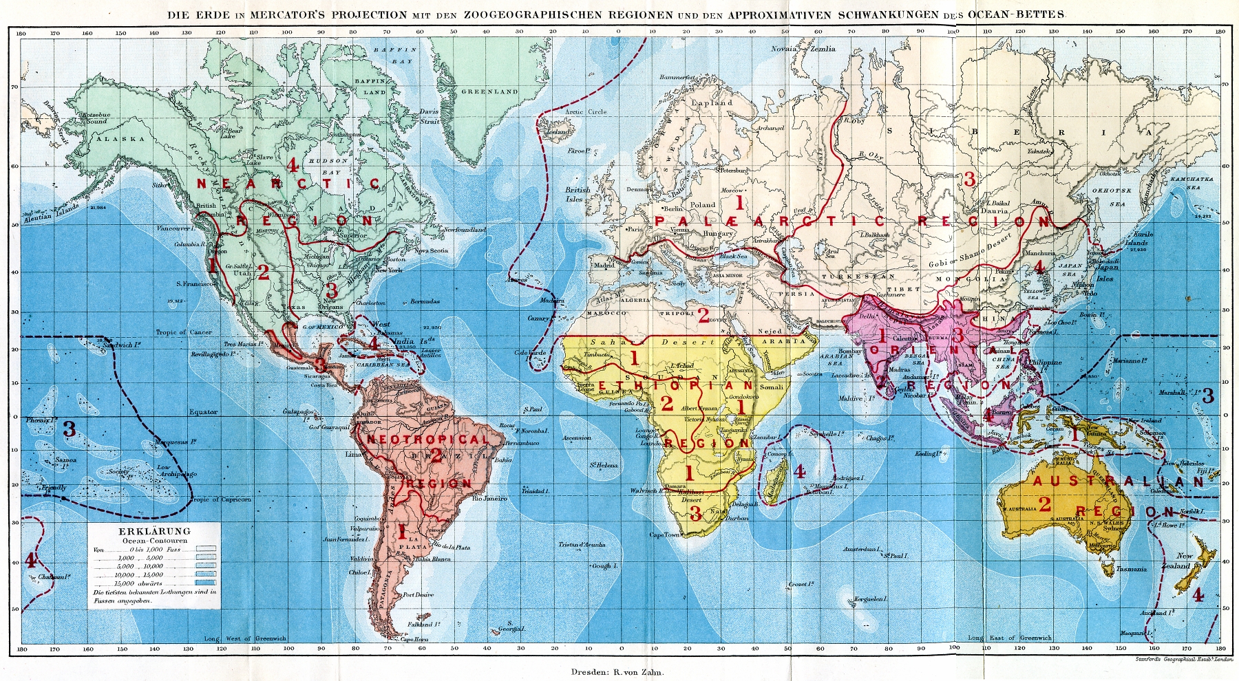
Deutsch: Weltkarte mit den Zoogeographischen Regionen
English: World map showing the zoogeographical regions
Español: Mapa del mundo que muestra las regiones zoogeográficas
|
||||
| Dato | |||||
| Fonto |
Deutsch: Die geographische Verbreitung der Thiere; nebst einer Studie über die Verwandtschaften der lebenden und ausgestobenen Faunen in ihrer Beziehung zu den früheren Veränderungen der Erdoberfläche. Autorisirte deutsche Ausgabe von A. B. Meyer (Originaltitel: The geographical distribution of animals; with a study of the relations of living and extinct faunas as elucidating the past changes of the Earth's surface). Verlag R. von Zahn, Dresden.
English: Die geographische Verbreitung der Thiere; nebst einer Studie über die Verwandtschaften der lebenden und ausgestobenen Faunen in ihrer Beziehung zu den früheren Veränderungen der Erdoberfläche. Authorized German edition by A.B. Meyer (original title: The geographical distribution of animals; with a study of the relations of living and extinct faunas as elucidating the past changes of the Earth's surface). Verlag R. von Zahn, Dresden.
Español: Die geographische Verbreitung der Thiere ... [La distribución geográfica de los animales ...] Autorizada edición alemana, ed. por A.B. Meyer (título original completo: The geographical distribution of animals; with a study of the relations of living and extinct faunas as elucidating the past changes of the Earth's surface). Verlag R. von Zahn, Dresden. |
||||
| Aŭtoro | Alfred Russel Wallace | ||||
| Permeso (Reuzo de la dosiero) |
|
||||
| Ceteraj versioj |
|
||||

Permesiloj:
|
Tiu ĉi verko estas publika havaĵo en tiuj landoj, kies kopirajtado validas por longo de vivo plus 70 jaroj aŭ malpli.
| |
| Estis konkludite ke uzon de ĉi tiu dosiero limigas neniu konata aŭtorrajta leĝo, kio inkluzivas ĉiujn rilatajn kaj apudajn rajtojn. | |
Dosierhistorio
Alklaku iun daton kaj horon por vidi kiel la dosiero tiam aspektis.
| Dato/Horo | Bildeto | Grandecoj | Uzanto | Komento | |
|---|---|---|---|---|---|
| nun | 19:22, 5 mar. 2007 | | 1 800 × 990 (2,27 MB) | Dysmachus | {{Information| |Description= {{de|Weltkarte mit den Zoogeographischen Regionen}} {{en|World map showing the zoogeographical regions}} |Source=Wallace, A.R. (1876): ''Die geographische Verbreitung der Thiere''. - Deutsche Ausgabe von A.B. Meyer; Dresden: |
Dosiera uzado
La jena paĝo ligas al ĉi tiu dosiero:
Suma uzado de la dosiero
La jenaj aliaj vikioj utiligas ĉi tiun dosieron:
- Uzado en af.wikipedia.org
- Uzado en ar.wikipedia.org
- Uzado en ast.wikipedia.org
- Uzado en azb.wikipedia.org
- Uzado en az.wikipedia.org
- Uzado en be-tarask.wikipedia.org
- Uzado en be.wikipedia.org
- Uzado en bg.wikipedia.org
- Uzado en bn.wikipedia.org
- Uzado en bs.wikipedia.org
- Uzado en ca.wikipedia.org
- Uzado en ce.wikipedia.org
- Uzado en ckb.wikipedia.org
- Uzado en cs.wikipedia.org
- Uzado en de.wikipedia.org
- Uzado en en.wikipedia.org
- Uzado en es.wikipedia.org
- Uzado en fi.wikipedia.org
- Uzado en fr.wikipedia.org
- Uzado en gl.wikipedia.org
- Uzado en hr.wikipedia.org
- Uzado en hu.wikipedia.org
- Uzado en hy.wikipedia.org
- Uzado en id.wikipedia.org
Vidi plian ĝeneralan uzadon de ĉi tiu dosiero.