
Dosiero:Yellowstone Lake from space.jpg
Bildo en pli alta difino ((3 032 × 2 008 rastrumeroj, grandeco de dosiero: 3,08 MB, MIME-tipo: image/jpeg))
| Jen dosiero de la Wikimedia-Komunejo. La priskribo en ties priskriba paĝo estas montrata suben.
|
Resumo
| Priskribo |
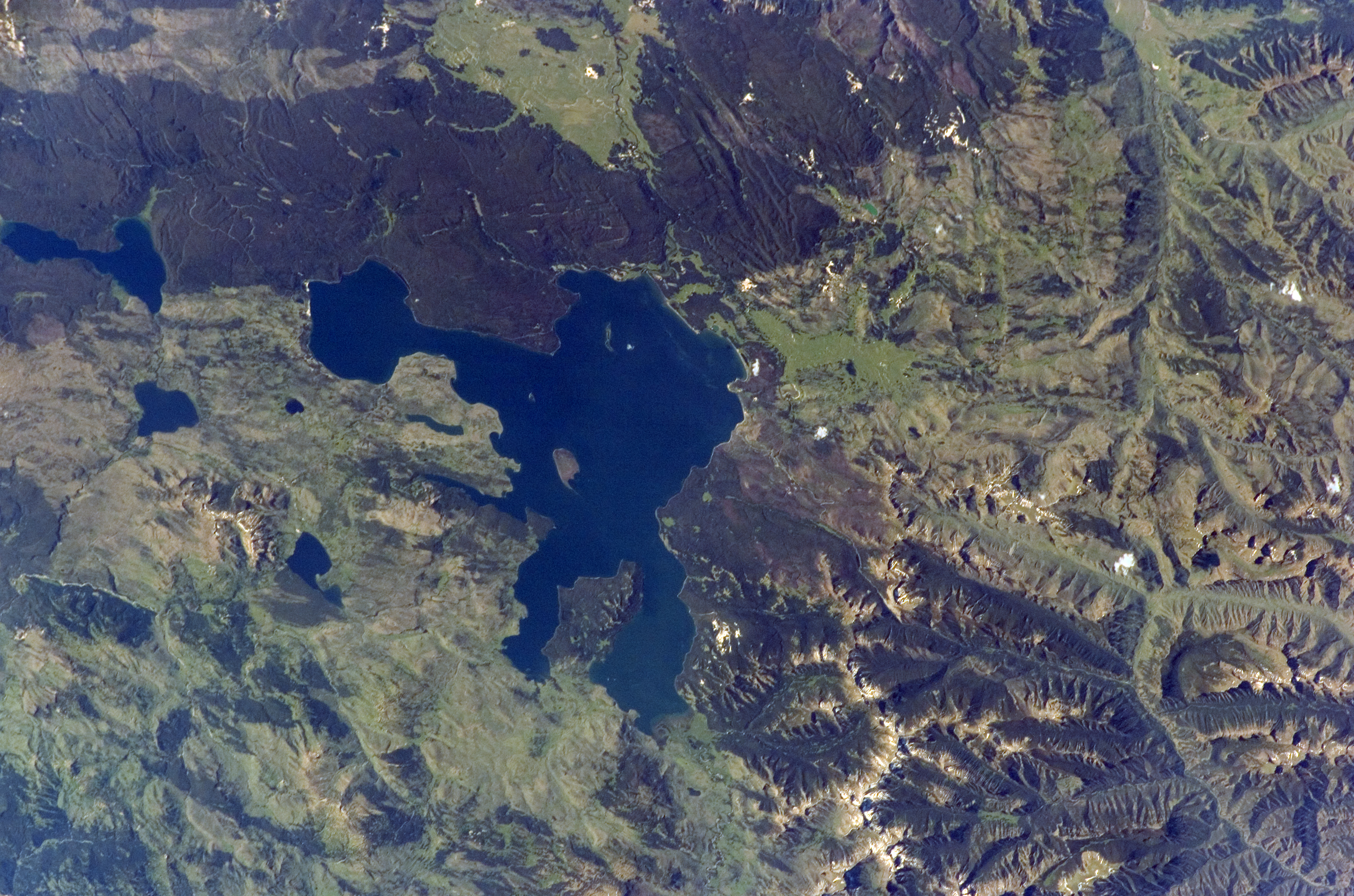
English: Huge volcanic eruptions that occurred over the past 2 million years formed Yellowstone National Park’s striking landscape. Two eruptions from 1.2 million and 600,000 years ago ejected more than 1,000 cubic kilometers (240 cubic miles) of material each, making them among the largest volcanic eruptions known in the Earth’s geologic record. At the same time, the emptying of the magma chambers beneath Yellowstone created large surface depressions called calderas. The youngest caldera measures nearly 80 kilometers (50 miles) long by 50 kilometers (31 miles) wide. Thought by most geologists to be the current location of a “hot spot” of upwelling, hot material from Earth’s mantle, the continuing activity of the region is demonstrated by its geysers, hot springs, and boiling mud pots.
This astronaut photograph is centered on Yellowstone Lake, a popular camping and fishing location within the National Park. The lake basin includes part of the youngest caldera and has an area of 352 square kilometers (136 square miles). Due to the rise and fall of resurgent domes (the locations of volcanic vents) located nearby, the lake basin is now tilted southwards, causing beaches to grow along the northern shore and flooding to occur in the southern arms of the lake. The West Thumb of Yellowstone Lake was formed by an eruption that occurred approximately 150,000 years ago. The resulting relatively small caldera was subsequently filled with water and joined with the larger lake to the east. Numerous geothermal features such as geysers and hot springs are located in the West Thumb area— this is thought to be due to a relatively shallow, local magma source. A more recent change to Yellowstone’s geography is the area covered by large fire scars— cleared areas burned during the vast 1988 forest fires. The scars are still highly visible 17 years later because the light-colored cleared regions contrast with the surrounding forest. Astronaut photograph ISS011-E-10575 was acquired July 15, 2005 with a Kodak 760C digital camera with an 180 mm lens, and is provided by the ISS Crew Earth Observations experiment and the Image Science & Analysis Group, Johnson Space Center. The International Space Station Program supports the laboratory to help astronauts take pictures of Earth that will be of the greatest value to scientists and the public, and to make those images freely available on the Internet. Additional images taken by astronauts and cosmonauts can be viewed at the NASA/JSC Gateway to Astronaut Photography of Earth. |
| Dato | Fotita je la 15-a de julio 2005, 23:13 |
| Fonto | https://eol.jsc.nasa.gov/SearchPhotos/photo.pl?mission=ISS011&roll=E&frame=10575 |
| Aŭtoro | NASA Johnson Space Center - Earth Sciences and Image Analysis (NASA-JSC-ES&IA) |
This image or video was catalogued by Johnson Space Center of the United States National Aeronautics and Space Administration (NASA) under Photo ID: ISS011-E-10575. This tag does not indicate the copyright status of the attached work. A normal copyright tag is still required. See Commons:Licensing. Other languages:
|
Permesiloj:
This file is in the public domain in the United States because it was created by the Image Science & Analysis Laboratory, of the NASA Johnson Space Center. NASA copyright policy states that "NASA material is not protected by copyright unless noted". (NASA media use guidelines or Conditions of Use of Astronaut Photographs).
Photo source: ISS011-E-10575.
|
Dosierhistorio
Alklaku iun daton kaj horon por vidi kiel la dosiero tiam aspektis.
| Dato/Horo | Bildeto | Grandecoj | Uzanto | Komento | |
|---|---|---|---|---|---|
| nun | 12:44, 6 apr. 2017 | | 3 032 × 2 008 (3,08 MB) | Ras67 | new rendered in native resolution and high quality from NASA's raw image data |
| 21:37, 5 sep. 2005 |  | 1 000 × 662 (521 KB) | Tom | {{PD-USGov-NASA}} http://eobglossary.gsfc.nasa.gov/Newsroom/NewImages/Images/ISS011-E-10575_lrg.jpg Huge volcanic eruptions that occurred over the past 2 million years formed Yellowstone National Park’s striking landscape. Two eruptions from 1.2 milli |
Dosiera uzado
La jena paĝo ligas al ĉi tiu dosiero:
Suma uzado de la dosiero
La jenaj aliaj vikioj utiligas ĉi tiun dosieron:
- Uzado en ca.wikipedia.org
- Uzado en en.wikipedia.org
- Uzado en en.wikinews.org
- Uzado en hy.wikipedia.org
- Uzado en ru.wikipedia.org