
Dosiero:Countries adopting Metric System 2006.png
Grandeco de ĉi antaŭvido: 800 × 382 rastrumeroj. Aliaj distingivoj: 320 × 153 rastrumeroj | 640 × 306 rastrumeroj | 1 243 × 594 rastrumeroj.
Bildo en pli alta difino ((1 243 × 594 rastrumeroj, grandeco de dosiero: 172 KB, MIME-tipo: image/png))
| Jen dosiero de la Wikimedia-Komunejo. La priskribo en ties priskriba paĝo estas montrata suben.
|

|
File:Countries adopting Metric System 2006.svg estas vektora versio de ĉi tiu bildo. Ĝi estu uzata anstataŭ ĉi tiu rastruma bildo, se ĝi ne estas malpli bonkvalita.
File:Countries adopting Metric System 2006.png → File:Countries adopting Metric System 2006.svg
Pliajn informojn vidu ĉe Help:SVG. |
 |
| Priskribo |
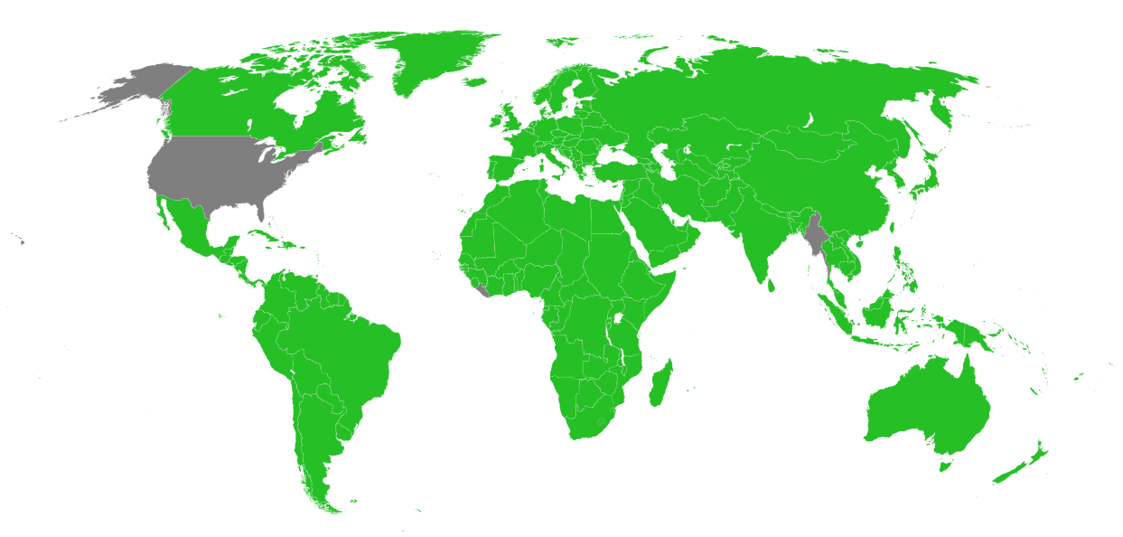
English: A map of the countries having officially adopted the Metric System, according to the US CIA World Factbook, 2006. |
| Dato | (UTC) |
| Fonto | |
| Aŭtoro |
|
Mi, la posedanto de la aŭtorrajto por ĉi tiu verko, ĉi-maniere publikigas tiun laŭ la jena permesilo:
| Mi, la posedanto de la aŭtorrajto por ĉi tiu verko, liberigas ĝin tutmonde kiel publikan havaĵon. En iuj landoj tio povas esti laŭleĝe neebla; en tiu okazo: Mi rajtigas ĉiun ajn uzi ĉi tiun verkon por ajna celo, sen iuj ajn kondiĉoj, krom se tiuj kondiĉoj estas postulataj per leĝo. |
Originala alŝutada protokolo
This image is a derivative work of the following images:
- Image:BlankMap-World6.svg licensed with PD-self
- 2008-03-29T00:30:24Z Canuckguy 940x477 (1605206 Bytes) fixed error found: Sao Tome (code "st") was messing with the coast tag ("coast" ends in "st") on some maps. Changed "land", "coast", "circle" and "sub" tags to "landxx", "coastxx", "circlexx" and "subxx" to prevent further
- 2008-02-28T03:55:15Z Canuckguy 940x477 (1604123 Bytes) re-added missing Honduras
- 2008-02-27T21:20:02Z Canuckguy 940x477 (1602296 Bytes) make borders touch, add circles for French DOMs and Chinese SARs, undo rounding of numbers, delete some extraneous nodes.
- 2008-02-02T18:38:58Z AzaToth 940x477 (881503 Bytes) rounding the values to near whole numbers. I don't think the decimals will do any visible difference at all.
- 2007-12-14T02:57:29Z Lokal Profil 940x477 (1616830 Bytes) a class fix to France. Moved the france group further down to not cover andorra circle etc. Got rid of som translate tags by recalculating the paths.
- 2007-12-09T20:27:34Z Canuckguy 940x477 (1616719 Bytes) thinner line for borders
- 2007-12-09T03:58:49Z Canuckguy 940x477 (1616984 Bytes) changes to France (see description and discussion pages), added a class for islands without an international border that makes the coastline thinner
- 2007-11-08T22:20:44Z Ketiltrout 940x477 (1614834 Bytes) Move Disko Island and the Bahamas back to their rightful places
- 2007-10-06T20:29:38Z Canuckguy 940x477 (1614582 Bytes) removed unneeded classes
- 2007-09-25T02:52:30Z Canuckguy 940x477 (1631712 Bytes) Moved css classes around and added a few additional instructions in the css for colouring the map. Fixed a few errors that were reverted.
- 2007-09-17T22:06:35Z Lokal Profil 940x477 (1632888 Bytes) aq_land (and arctic) to aq, removed two formating cludges which didn't make any visual difference, Replaced swaziland by formating cludge around swaziland and renamed, removed duplicat "ki" entry (probably left by me last tim
- 2007-09-13T18:52:32Z Lokal Profil 940x477 (1635420 Bytes) Basically same edits as Canuckguy but in a text editor so as to eliminate Inksacape junk code and preserve the style structure. Also made sure all circles are above the surrounding countries.
- 2007-09-10T05:54:39Z Canuckguy 940x477 (1915635 Bytes) Simplified circles - now in same layer as countries (making the whole file one layer), simplified a few other things as detailed on the changes in the descrption on the talk page.
- 2007-09-09T03:03:49Z Lokal Profil 940x477 (1632593 Bytes) Added ISO-id to Mongolia, Bhutan and Andorra circle, Corrected id of Malawi, made "Swaziland border path" transparent so that colour of underlying path becomes visible. Also removed Inkscape objects, cleaned out a lot of blan
- 2007-08-29T21:14:30Z H2g2bob 940x477 (1630393 Bytes) Remove class="..." from elements if parent has same or similar class, allowing for inheritance of style rules.
- 2007-08-25T22:15:44Z H2g2bob 940x477 (1686400 Bytes) Update to map to include styles in CSS stylesheet using <svg:style> tags. This allows changing the style of the entire map in one go. This edit was done in a text editor.
- 2007-08-22T00:27:08Z Canuckguy 940x477 (2019787 Bytes) fixed a few problems with previous version (restored small countries circles, fixed problem with Germany and Serbia)
- 2007-07-08T21:00:39Z Andrew pmk 940x477 (2021488 Bytes) Remove lots of small islands which are not visible or barely visible at normal zoom levels; clean up borders so that boundaries are included in the main country groups, rather than being separate objects; make background all
- 2007-07-04T00:04:59Z AzaToth 940x477 (2265956 Bytes) Minor optimizations using perl SVG::Parser and SVG modules (reparsing the tree)
- 2007-01-09T03:38:38Z Roke 940x477 (2370958 Bytes) Reverted to earlier revision
- 2007-01-09T03:37:25Z Roke 940x477 (2549763 Bytes) hidden layers: separate non-sovereign & sovereign circles, text
- 2006-12-29T04:02:15Z Canuckguy 940x477 (2370958 Bytes)
- 2006-12-10T10:34:46Z Brianski 940x477 (2209317 Bytes) re-optimized with optisvg.pl
- 2006-11-26T06:54:55Z Canuckguy 940x477 (2370957 Bytes) deleted Aksai Chin, awarded territory to China (nation of control, as India is pictured as the nation of control over Arunchal Pradesh). Revised from previous version by me, so may need optimizing by Brianski's tool again (s
- 2006-11-23T11:27:06Z Brianski 940x477 (2273821 Bytes) optimized using Brian Szymanski's optisvg.pl
- 2006-11-21T23:09:04Z Canuckguy 940x477 (2440482 Bytes) a few more minor tweaks
- 2006-11-12T04:13:48Z Hexagon1 940x477 (2365940 Bytes) Canuckguy's fixed some errors
- 2006-11-12T02:02:50Z Hexagon1 940x765 (2318315 Bytes) Detailed SVG map with grouping enabled to connect all non-contiguous parts of a country's territory for easy colouring.
Uploaded with derivativeFX
Dosierhistorio
Alklaku iun daton kaj horon por vidi kiel la dosiero tiam aspektis.
| Dato/Horo | Bildeto | Grandecoj | Uzanto | Komento | |
|---|---|---|---|---|---|
| nun | 09:56, 23 okt. 2008 | | 1 243 × 594 (172 KB) | Mkoistinen | {{Information |Description=A map of the countries having officially adopted the Metric System, according to the US CIA World Factbook, 2006. |Source=*Image:BlankMap-World6.svg |Date=2008-10-23 09:54 (UTC) |Author=*derivative work: ~~~ *[[:Image:Blan |
Dosiera uzado
Neniu paĝo ligas al ĉi tiu dosiero.