
Dosiero:Greece in 1210.svg

Grando de tiu PNG antaŭprezento de tiu SVGa dosiero: 800 × 456 rastrumeroj. Aliaj distingivoj: 320 × 182 rastrumeroj | 640 × 365 rastrumeroj | 1 024 × 584 rastrumeroj | 1 280 × 730 rastrumeroj | 2 560 × 1 460 rastrumeroj | 3 508 × 2 000 rastrumeroj.
Bildo en pli alta difino (SVG-dosiero, 3 508 × 2 000 rastrumeroj, grandeco de dosiero: 1,12 MB)
| Jen dosiero de la Wikimedia-Komunejo. La priskribo en ties priskriba paĝo estas montrata suben.
|
Resumo
| Priskribo |
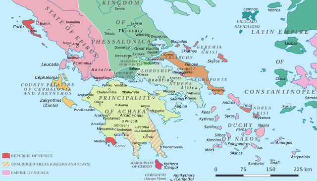
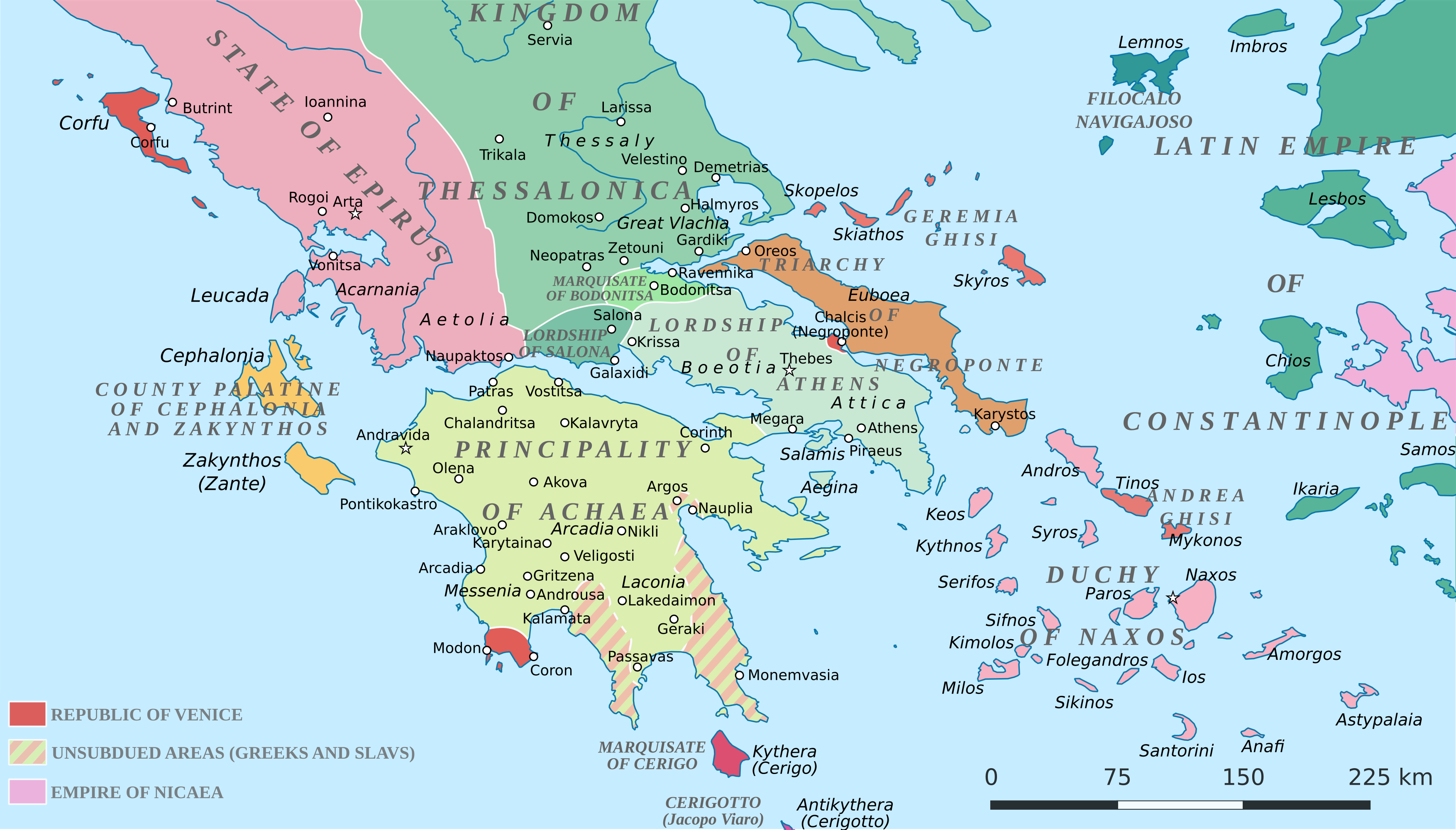
English: Political map of southern Greece in c. 1210, after the establishment of the Crusader states following the Fourth Crusade. |
| Dato | |
| Fonto |
SVG base from File:Greece in 1210V1.svg; based on the original political map by William Miller (1908), with changes and corrections to account for newer scholarship:
|
| Aŭtoro | Cplakidas |
| Ceteraj versioj |
|


Permesiloj:
Mi, la posedanto de la aŭtorrajto por ĉi tiu verko, ĉi-maniere publikigas tiun laŭ la jena permesilo:
Ĉi tiu dosiero disponeblas laŭ la permesilo Krea Komunaĵo Atribuite-Samkondiĉe 4.0 Tutmonda.
- Vi rajtas:
- kunhavigi – kopii, distribui kaj publikigi la verkon
- aliigi – modifi, adapti, kompletigi, transformi, uzi la tutan verkon aŭ ties partojn, memstare aŭ en aliaj verkoj
- La verko rajtas esti kunhavigata nur:
- atribuite – Vi devas atribui aŭtorecon, liveri ligilon al la permesilo kaj marki ĉu ŝanĝoj estis faritaj. Faru tion en aprobinda maniero, tamen ne sugestante, ke permesinto aprobas vin aŭ vian uzon.
- samkondiĉe – Se vi rekombinas la verkon, transformas ĝin aŭ kreas devenaĵon bazitan sur ĝi, vi rajtas distribui la rezultan verkon nur laŭ la sama aŭ kongrua permesilo kompare kun ĉi tiu.
Dosierhistorio
Alklaku iun daton kaj horon por vidi kiel la dosiero tiam aspektis.
| Dato/Horo | Bildeto | Grandecoj | Uzanto | Komento | |
|---|---|---|---|---|---|
| nun | 19:59, 23 jun. 2017 | | 3 508 × 2 000 (1,12 MB) | Cplakidas | fixed three names to paths |
| 12:08, 11 apr. 2017 |  | 3 508 × 2 000 (1,1 MB) | Cplakidas | colour changes | |
| 11:48, 11 apr. 2017 |  | 3 508 × 2 000 (1,11 MB) | Cplakidas | tweak around Coron | |
| 10:39, 11 feb. 2017 |  | 3 508 × 2 000 (1,11 MB) | Cplakidas | tweaks in Negroponte, unsubdued areas | |
| 17:57, 8 feb. 2017 |  | 3 508 × 2 000 (1,11 MB) | Cplakidas | tweaking the Morea | |
| 13:40, 8 feb. 2017 |  | 3 508 × 2 000 (1,11 MB) | Cplakidas | slight tweaks | |
| 13:14, 8 feb. 2017 |  | 3 508 × 2 000 (1,11 MB) | Cplakidas | User created page with UploadWizard |
Dosiera uzado
La jena paĝo ligas al ĉi tiu dosiero:
Suma uzado de la dosiero
La jenaj aliaj vikioj utiligas ĉi tiun dosieron:
- Uzado en ar.wikipedia.org
- Uzado en az.wikipedia.org
- Uzado en bg.wikipedia.org
- Uzado en ca.wikipedia.org
- Uzado en da.wikipedia.org
- Uzado en de.wikipedia.org
- Uzado en el.wikipedia.org
- Uzado en en.wikipedia.org
- Uzado en eu.wikipedia.org
- Uzado en fa.wikipedia.org
- Uzado en fr.wikipedia.org
- Uzado en gl.wikipedia.org
- Uzado en hr.wikipedia.org
- Uzado en id.wikipedia.org
- Uzado en it.wikipedia.org
- Uzado en ja.wikipedia.org
- Uzado en ko.wikipedia.org
- Uzado en ro.wikipedia.org
- Uzado en ru.wikipedia.org
- Uzado en sk.wikipedia.org
- Uzado en sr.wikipedia.org
Vidi plian ĝeneralan uzadon de ĉi tiu dosiero.