
Dosiero:Irene Aug 24 2011 1810Z.jpg

Bildo en pli alta difino ((6 400 × 8 200 rastrumeroj, grandeco de dosiero: 25,48 MB, MIME-tipo: image/jpeg))
| Jen dosiero de la Wikimedia-Komunejo. La priskribo en ties priskriba paĝo estas montrata suben.
|
| Atentu | La originala dosiero havas multe da bilderoj, kaj lanĉi ĝin plen-distingive povus kaŭzi mis-ŝargon aŭ frostigon de retumilo. Tiujn problemojn oni povas eviti per uzado de ZoomViewer. |
|---|
Resumo
| Priskribo |
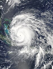
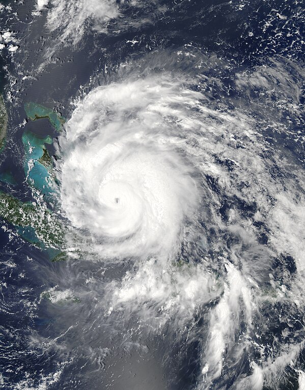
English: Hurricane Irene strengthened on its path toward the continental United States in late August 2011. Residents of the U.S. East Coast braced for the first hurricane to seriously threaten the country in three years, Voice of America reported.
The Moderate Resolution Imaging Spectroradiometer (MODIS) on NASA’s Aqua satellite captured this natural-color image at 2:15 p.m. local time (18:15 UTC) on August 24. Storm clouds hide the Turks and Caicos Islands, and extend westward over The Bahamas. Clouds also linger over the Dominican Republic and Haiti. At 2:00 p.m. Eastern Daylight Time on August 24, about the time MODIS took this picture, the U.S. National Hurricane Center (NHC) reported that Irene was a Category 3 hurricane with maximum sustained winds of 120 miles (195 kilometers) per hour. By 5:00 a.m. EDT on August 25, the NHC reported, Irene’s winds had weakened slightly, to 115 miles (185 kilometers) per hour. The storm remained a powerful Category 3 hurricane. A hurricane warning was in effect for the southeastern, central, and northwestern Bahamas. A hurricane watch was in effect for Surf City, North Carolina, northward to the Virginia border. A tropical storm watch was in effect for Edisto Beach, South Carolina, north to Surf City. As of 5:00 a.m. EDT on August 25, Irene was moving toward the northwest at about 12 miles (19 kilometers) per hour. The storm was expected to turn toward the north-northwest the same day, then toward the north early the following day. The NHC five-day storm track showed Irene moving northward along the U.S. East Coast. As U.S. residents braced for Irene’s arrival, residents of Caribbean Islands cleaned up from the destructive storm. The Christian Science Monitor reported that flooding and mudslides had forced the Dominican Republic to evacuate nearly 38,000 people, and a U.S.-based analysis firm estimated potential damage in the Caribbean at up to $3.1 billion. |
| Dato | |
| Fonto | http://earthobservatory.nasa.gov/NaturalHazards/view.php?id=51867 |
| Aŭtoro | NASA image courtesy Jeff Schmaltz, MODIS Rapid Response, NASA Goddard Space Flight Center. Caption by Michon Scott. |
Permesiloj:
| La ĉi-supra dosiero estas publika havaĵo, ĉar ĝi apartenas al NASA. La kopirajta regularo de NASA asertas, ke "ĉiuj dokumentoj de NASA estas publika havaĵo, se ne estas donata kontraŭa deklaro". | ||
 |
Atentu:
|
Dosierhistorio
Alklaku iun daton kaj horon por vidi kiel la dosiero tiam aspektis.
| Dato/Horo | Bildeto | Grandecoj | Uzanto | Komento | |
|---|---|---|---|---|---|
| nun | 06:49, 29 okt. 2019 | | 6 400 × 8 200 (25,48 MB) | Nino Marakot | Reverted to version as of 22:50, 29 July 2013 (UTC) - Reverting to final re-upload by Supportstorm |
| 23:26, 15 apr. 2018 |  | 8 232 × 9 737 (55,25 MB) | MarioProtIV | Reverted to version as of 02:33, 14 November 2012 (UTC) | |
| 23:07, 29 mar. 2018 |  | 1 400 × 1 700 (402 KB) | CooperScience | Centering image | |
| 22:50, 29 jul. 2013 |  | 6 400 × 8 200 (25,48 MB) | Supportstorm | Gallery version | |
| 02:33, 14 nov. 2012 |  | 8 232 × 9 737 (55,25 MB) | Supportstorm | HDF File Quality Image | |
| 21:36, 24 aŭg. 2011 |  | 6 620 × 6 620 (6,45 MB) | Supportstorm | {{Information |Description ={{en|1=Major Hurricane Irene on August 24, 2011 as a category three.}} |Source =http://lance-modis.eosdis.nasa.gov/wms/?zoom=3&lat=21.75&lon=-16.18359&layers=000B0FFFFFFT&datum1=08/24/2011 |Author =NASA, MODI |
Dosiera uzado
La jena paĝo ligas al ĉi tiu dosiero:
Suma uzado de la dosiero
La jenaj aliaj vikioj utiligas ĉi tiun dosieron:
- Uzado en ar.wikipedia.org
- Uzado en de.wikipedia.org
- Uzado en en.wikipedia.org
- Uzado en es.wikipedia.org
- Uzado en es.wikinews.org
- Uzado en eu.wikipedia.org
- Uzado en fa.wikipedia.org
- Uzado en fi.wikipedia.org
- Uzado en fr.wikipedia.org
- Uzado en hi.wikipedia.org
- Uzado en id.wikipedia.org
- Uzado en is.wikipedia.org
- Uzado en it.wikipedia.org
- Uzado en ja.wikipedia.org
- Uzado en jv.wikipedia.org
- Uzado en ko.wikipedia.org
- Uzado en ms.wikipedia.org
- Uzado en nl.wikipedia.org
- Uzado en pl.wikipedia.org
- Uzado en pt.wikipedia.org
- Uzado en ro.wikipedia.org
- Uzado en ru.wikipedia.org
- Uzado en ru.wikinews.org
- Uzado en simple.wikipedia.org
- Uzado en ta.wikipedia.org
- Uzado en th.wikipedia.org
- Uzado en uk.wikipedia.org
- Uzado en vi.wikipedia.org
- Uzado en www.wikidata.org
- Uzado en zh.wikipedia.org