
Dosiero:India Punjab locator map.svg

Bildo en pli alta difino (SVG-dosiero, 1 574 × 1 738 rastrumeroj, grandeco de dosiero: 836 KB)
| Jen dosiero de la Wikimedia-Komunejo. La priskribo en ties priskriba paĝo estas montrata suben.
|

|
This file requires updating because: Newly-created Fazilka district needs to be accommodated In doing so, you could add a timestamp to the file.
|
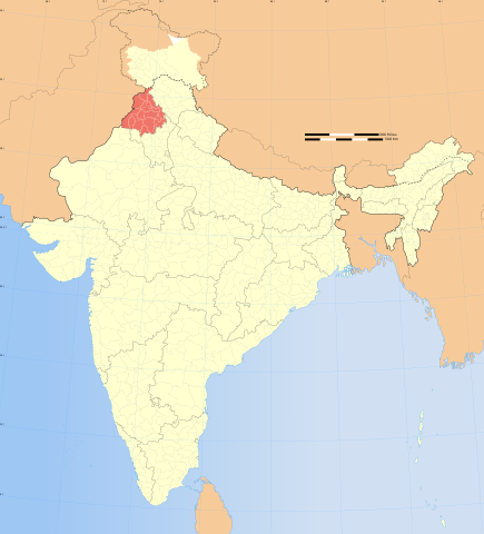
| Titolo |
Punjab locator map |
|||||||||
| Priskribo |
Locator map of the state of Kashmir, India with district boundaries. |
|||||||||
| Map legend |
 |
|||||||||
| Dato | ||||||||||
| Fonto |
Propra verko |
|||||||||
| Kreinto |
|
|||||||||
| Permeso (Reuzo de la dosiero) |
Mi, la posedanto de la aŭtorrajto por ĉi tiu verko, ĉi-maniere publikigas tiun laŭ la jena permesilo: Ĉi tiu dosiero estas disponebla laŭ la permesilo Krea Komunaĵo Atribuite-Samkondiĉe 3.0 Neadaptita.
|
|||||||||
| Geotemporal data | ||||||||||
| Montrata dato | dua duono de 20-a jarcento kaj 21-a jarcento | |||||||||
| Spatial reference system | conic | |||||||||
| Bounding box |
|
|||||||||
| Georeferencing | If inappropriate please set warp_status = skip to hide. | |||||||||
| Archival data | ||||||||||
| Notoj | Part of WikiProject India Maps | |||||||||
| Ceteraj versioj |
|
|||||||||


Notes
Depiction of India's borders
- The territorial boundaries of India are shown as per the actual ground situation in accordance with international practices followed by the United Nations ([1], [2]) and the National Geographic Society ([3], [4])
- This map is meant to be for illustrative purpose only and is not authenticated by official government sources. Please check the list of sources and references used to create the map for a measure of accuracy and verifiability.
- The usage of these maps in India, Pakistan and China are governed by different laws that restrict depictions of boundaries other than what is officially recognized by the state. Please check local laws and modify the map accordingly before use.
Explanation of disputed boundaries


- Boundary of Indian claim : The territory India claims is legally theirs, but the claim is disputed by China and Pakistan.
- Line of Control/Line of Conflict : The de facto administrative boundary recognised by the international community. This UN ceasefire line is considered as a temporary solution to an ongoing conflict since the departure of the British Raj.
Borders of disputed regions
The depicted extent of the former territory of the British Indian Empire, succeeded by Republic of India, may not be accepted by few countries as legal due to ongoing border disputes:
- The northern Himalayan region of the disputed territory Indian-administered Kashmir is claimed by India including (Pakistan-administered Kashmir) and the Chinese-occupied territory of (Ladakh plateau). Since 1972, it is divided between all three countries. See also Line of Control and Line of Actual Control.
- Siachen glacier (shown white) is an actively contested region between India and Pakistan. Since 1984, the region is under Indian control.
- The northeastern territory of Arunachal Pradesh is almost entirely claimed by China as part of its Tibetan territory.
- Minor areas of eastern Kashmir's Ladakh division, Himachal Pradesh and Uttarakhand on the Chinese frontier are claimed by China. These areas are under Indian control.
- A small area of Uttarakhand adjoining the Nepal border along the Sarda river is disputed between the two countries.
For a detailed map of all disputed regions in South Asia, see Image:India disputed areas map.svg
Internal borders
The borders of the state of Meghalaya, Assam and Arunachal Pradesh are shown as interpreted from the North-Eastern Areas (Reorganisation) Act, 1971, but has yet to be verified.
Territorial waters
The limit of the territorial waters of India extends to twelve nautical miles measured from the appropriate baseline. See this for more information.
Dosierhistorio
Alklaku iun daton kaj horon por vidi kiel la dosiero tiam aspektis.
| Dato/Horo | Bildeto | Grandecoj | Uzanto | Komento | |
|---|---|---|---|---|---|
| nun | 07:09, 29 dec. 2008 | | 1 574 × 1 738 (836 KB) | Planemad | {{Information |Description= |Source= |Date= |Author= |Permission= |other_versions= }} |
| 17:45, 6 aŭg. 2006 |  | 1 639 × 1 852 (751 KB) | Planemad | {{WikiProject_India_Maps |Title=Punjab locator map |Description=Locator map of the state of Punjab, India with district boundaries. |Source=. |Date=August 6 2006 |Author=w:user:Nichalpw:user:Planemad |Thumbdir=CHANGE }} |
Dosiera uzado
La jena paĝo ligas al ĉi tiu dosiero:
Suma uzado de la dosiero
La jenaj aliaj vikioj utiligas ĉi tiun dosieron:
- Uzado en ba.wikipedia.org
- Uzado en be.wikipedia.org
- Uzado en bg.wikipedia.org
- Uzado en bh.wikipedia.org
- Uzado en bn.wikipedia.org
- Uzado en br.wikipedia.org
- Uzado en ckb.wikipedia.org
- Uzado en da.wikipedia.org
- Uzado en dty.wikipedia.org
- Uzado en en.wikipedia.org
- Talk:Punjabi language
- Talk:Khalistan movement
- Talk:Sikhism
- Talk:Mitra
- Talk:Operation Blue Star
- Talk:Bathinda
- Talk:Amritsar
- Talk:Manmohan Singh
- Talk:Sukerchakia Misl
- Talk:Guru Ram Das
- Talk:Gatka
- Talk:Ranjit Singh
- Talk:Music of Punjab
- Talk:Malik
- Talk:Ika Omkara
- Talk:Jalandhar
- Hakim Pur, Doaba Region
- Qila Raipur
- Talk:Khaira, Ludhiana
- Talk:Damdami Taksal
- Talk:Bulleh Shah
- Rauni, Ludhiana
- Talk:Bhagat Singh
- Talk:Kirtan Sohila
- Talk:Guru Har Krishan
- Talk:Guru Tegh Bahadur
- Talk:Guru Har Rai
- Mandi Mullanpur
- Talk:Zafarnama (letter)
- Talk:Iftikhar Ali Khan Pataudi
- Talk:Jagjit Singh Aurora
- Talk:Babbar Khalsa
- Harnam Singh Wala
- Talk:Waheguru
- Sobraon
- Talk:Bajwa
- Talk:Khemkaran
- Punjab Plain
- Talk:Gurdwara
- Talk:List of Sikhs
- Talk:Inderjit Singh Bindra Stadium
Vidi plian ĝeneralan uzadon de ĉi tiu dosiero.