
Dosiero:Island of Ireland location map Louth.svg

Grando de tiu PNG antaŭprezento de tiu SVGa dosiero: 481 × 599 rastrumeroj. Aliaj distingivoj: 192 × 240 rastrumeroj | 385 × 480 rastrumeroj | 616 × 768 rastrumeroj | 822 × 1 024 rastrumeroj | 1 643 × 2 048 rastrumeroj | 1 450 × 1 807 rastrumeroj.
Bildo en pli alta difino (SVG-dosiero, 1 450 × 1 807 rastrumeroj, grandeco de dosiero: 642 KB)
| Jen dosiero de la Wikimedia-Komunejo. La priskribo en ties priskriba paĝo estas montrata suben.
|
| Priskribo |
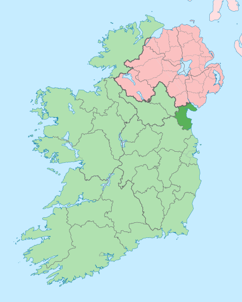
English: The island of Ireland, showing international border between Ireland and Northern Ireland, traditional provinces, traditional counties, and local authority areas in Ireland and Northern Ireland. |
| Dato | (UTC) |
| Fonto | |
| Aŭtoro |
|
| Ĉi tio estas modifita bildo, kio signifas, ke ĝi ekestis per cifereca aliigo de la origina versio. Modifoj: Coloured in regions with county of article highlighted. La originaĵo videblas ĉi tie: Island of Ireland location map.svg. La modifojn faris Mabuska.
|
Mi, la posedanto de la aŭtorrajto por ĉi tiu verko, ĉi-maniere publikigas tiun laŭ la jena permesilo:
Ĉi tiu dosiero estas disponebla laŭ la permesilo Krea Komunaĵo Atribuite-Samkondiĉe 3.0 Neadaptita.
- Vi rajtas:
- kunhavigi – kopii, distribui kaj publikigi la verkon
- aliigi – modifi, adapti, kompletigi, transformi, uzi la tutan verkon aŭ ties partojn, memstare aŭ en aliaj verkoj
- La verko rajtas esti kunhavigata nur:
- atribuite – Vi devas atribui aŭtorecon, liveri ligilon al la permesilo kaj marki ĉu ŝanĝoj estis faritaj. Faru tion en aprobinda maniero, tamen ne sugestante, ke permesinto aprobas vin aŭ vian uzon.
- samkondiĉe – Se vi rekombinas la verkon, transformas ĝin aŭ kreas devenaĵon bazitan sur ĝi, vi rajtas distribui la rezultan verkon nur laŭ la sama aŭ kongrua permesilo kompare kun ĉi tiu.
Originala alŝutada protokolo
This image is a derivative work of the following images:
- File:Island_of_Ireland_location_map.svg licensed with Cc-by-sa-3.0
- 2010-03-06T20:43:33Z Rannpháirtí anaithnid 1450x1807 (679207 Bytes) Fix incorrectly coloured isands.
- 2010-03-03T22:19:29Z Rannpháirtí anaithnid 1450x1807 (679744 Bytes) {{Information |Description={{de|Positionskarte von [[:de:Irland|Irland]]}} Quadratische Plattkarte, N-S-Streckung 170 %. Geographische Begrenzung der Karte: * N: 55.6° N * S: 51.2° N * W: 11.0° W * O: 5.0° W {{en|Location
Uploaded with derivativeFX
Dosierhistorio
Alklaku iun daton kaj horon por vidi kiel la dosiero tiam aspektis.
| Dato/Horo | Bildeto | Grandecoj | Uzanto | Komento | |
|---|---|---|---|---|---|
| nun | 09:13, 3 jul. 2020 | | 1 450 × 1 807 (642 KB) | Chipmunkdavis | Per the Local Government Reform Act 2014, joining both Tipperarys and both Waterfords (and removing Limerick City code). Colouring in islands, cleaning up and grouping code to remove stray objects and show Galway and Lough Ree. |
| 00:57, 19 jul. 2010 |  | 1 450 × 1 807 (815 KB) | Mabuska | {{Information |Description={{en|The island of Ireland, showing international border between Northern Ireland and Republic of Ireland, traditional provinces, traditional counties, and local authority areas in the Republic of Ireland and Northern Ireland.}} |
Dosiera uzado
La jena paĝo ligas al ĉi tiu dosiero:
Suma uzado de la dosiero
La jenaj aliaj vikioj utiligas ĉi tiun dosieron:
- Uzado en ar.wikipedia.org
- Uzado en ast.wikipedia.org
- Uzado en bg.wikipedia.org
- Uzado en ca.wikipedia.org
- Uzado en ceb.wikipedia.org
- Uzado en cs.wikipedia.org
- Uzado en da.wikipedia.org
- Uzado en en.wikipedia.org
- Drogheda
- County Louth
- List of Ireland-related topics
- Ardee
- Dunleer
- Greenore
- Jenkinstown, County Louth
- Carlingford, County Louth
- R178 road (Ireland)
- R176 road (Ireland)
- R175 road (Ireland)
- Omeath
- Gyles' Quay
- Blackrock, County Louth
- Collon
- Termonfeckin
- Dromiskin
- Ballymascanlan
- Tullyallen, County Louth
- Mansfieldtown
- Castlebellingham
- Louth, County Louth
- Clogherhead
- Baltray
- Cooley Peninsula
- Togher, County Louth
- Knockbridge
- Moneymore, Drogheda
- Haggardstown
- Template:Louth-geo-stub
- River Glyde
- Darver Castle
- River Fane
- Castletown River
Vidi plian ĝeneralan uzadon de ĉi tiu dosiero.