
Dosiero:LocationSouthAfrica-1990.png
Jen estas la maksimuma distingivo de la supra bildo.
LocationSouthAfrica-1990.png ((250 × 115 rastrumeroj, grandeco de dosiero: 5 KB, MIME-tipo: image/png))
| Jen dosiero de la Wikimedia-Komunejo. La priskribo en ties priskriba paĝo estas montrata suben.
|

|
File:South Africa in its region (1990).svg estas vektora versio de ĉi tiu bildo. Ĝi estu uzata anstataŭ ĉi tiu rastruma bildo, se ĝi ne estas malpli bonkvalita.
File:LocationSouthAfrica-1990.png → File:South Africa in its region (1990).svg
Pliajn informojn vidu ĉe Help:SVG. |
.svg) |
Resumo
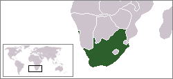
A locator map of South Africa showing en:Walvis Bay. This locator map is intended for South African articles taking place before the transfer of Walvis Bay to Namibia in 1994. The orginal map is by Vardion. Since that map is PD, this one is well.
Permesiloj:
| Ĉi tiu verko estis liberigita kiel publika havaĵo de ties aŭtoro, Hoshie. Tio aplikatas tutmonde. En iuj landoj tio povas esti laŭleĝe neebla; en tiu okazo: |
Dosierhistorio
Alklaku iun daton kaj horon por vidi kiel la dosiero tiam aspektis.
| Dato/Horo | Bildeto | Grandecoj | Uzanto | Komento | |
|---|---|---|---|---|---|
| nun | 07:26, 17 dec. 2009 | | 250 × 115 (5 KB) | Hoshie | Reverted to version as of 03:34, 16 August 2006 rv, Nambia itself wasn't a part of S. Africa |
| 18:37, 2 dec. 2008 |  | 250 × 115 (5 KB) | ChrisDHDR | South Africa included Namibia at the time | |
| 03:34, 16 aŭg. 2006 |  | 250 × 115 (5 KB) | Hoshie | == Summary == A locator map of South Africa showing en:Walvis Bay. This locator map is intended for South African articles taking place before the transfer of Walvis Bay to Nambia in 1994. The orginal map is by [[Us |
Dosiera uzado
Neniu paĝo ligas al ĉi tiu dosiero.