
Dosiero:Netherlands, Anloo, map of 1866.jpg

Bildo en pli alta difino ((1 200 × 1 070 rastrumeroj, grandeco de dosiero: 579 KB, MIME-tipo: image/jpeg))
| Jen dosiero de la Wikimedia-Komunejo. La priskribo en ties priskriba paĝo estas montrata suben.
|
Resumo
| Priskribo |
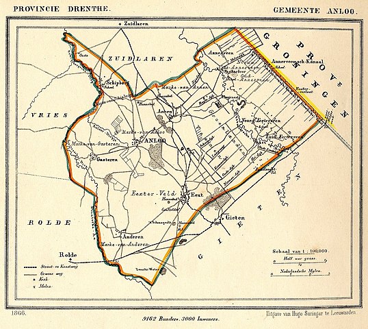
Nederlands: Kaart uit 1866 van de voormalige gemeente Anloo in de provincie Drenthe. Op 1 januari 1998 werd Anloo, samen met de (voormalige) gemeenten Rolde, Gasselte en Gieten samengevoegd tot de gemeente Aa en Hunze.
English: Map from 1866 of the former municipality of Anloo (Province of Drenthe, Netherlands). On January 1, 1998 Anloo, together with the (former) municipalities of Rolde, Gasselte and Gieten merged into the new municipality of Aa en Hunze. |
| Dato | 1866. Published around 1870 as part of a series of provincial atlases of the Netherlands. |
| Fonto | Gemeente-atlas van Nederland naar officieele bronnen bewerkt. |
| Aŭtoro | J. Kuyper |
| Permeso (Reuzo de la dosiero) |
This image is in the public domain. The author J. Kuyper died in 1908. [In the Netherlands copyright expires 70 years after the death of the author or 70 years after first publication in the case of anonymous or pseudonymous works or works published by a legal entity]. [Het auteursrecht in Nederland vervalt 70 jaar na de dood van de auteur of 70 jaar na de eerste openbaarmaking van het werk, indien het gaat om een anoniem of om een onder pseudoniem verschenen werk of werk van een rechtspersoon]. |
The church of Anloo is at:
| Pozicio de la fotilo | | Tiu cxi bildo kaj pliaj sur OpenStreetMap |
|---|
Permesiloj:
|
Tiu ĉi verko estas publika havaĵo en tiuj landoj, kies kopirajtado validas por longo de vivo plus 70 jaroj aŭ malpli.
| |
| Estis konkludite ke uzon de ĉi tiu dosiero limigas neniu konata aŭtorrajta leĝo, kio inkluzivas ĉiujn rilatajn kaj apudajn rajtojn. | |
Dosierhistorio
Alklaku iun daton kaj horon por vidi kiel la dosiero tiam aspektis.
| Dato/Horo | Bildeto | Grandecoj | Uzanto | Komento | |
|---|---|---|---|---|---|
| nun | 16:30, 5 jan. 2012 | | 1 200 × 1 070 (579 KB) | Loranchet | {{Information |Description ={{nl|1=Kaart uit 1866 van de voormalige gemeente Anloo in de provincie Drenthe. Op 1 januari 1998 werd Anloo, samen met de (voormalige) gemeenten Rolde, Gasselte en Gieten samengevoegd tot de gemeente Aa en Hunze.}} {{en|1=M |
Dosiera uzado
La jena paĝo ligas al ĉi tiu dosiero:
Suma uzado de la dosiero
La jenaj aliaj vikioj utiligas ĉi tiun dosieron:
- Uzado en fy.wikipedia.org
- Uzado en nds-nl.wikipedia.org
- Uzado en nl.wikipedia.org