Dosiero:Types of offshore oil and gas structures.jpg

Paĝenhavo ne ekzistas en aliaj lingvoj.
El Vikipedio, la libera enciklopedio

Types_of_offshore_oil_and_gas_structures.jpg((600 × 236 rastrumeroj, grandeco de dosiero: 97 KB, MIME-tipo: image/jpeg))

Jen dosiero de la Wikimedia-Komunejo. La priskribo en ties priskriba paĝo estas montrata suben.
La Komunejo estas dosieruja retejo de libere licencitaj dosieroj.

Resumo

Priskribo
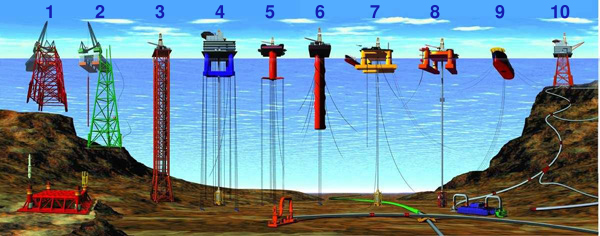
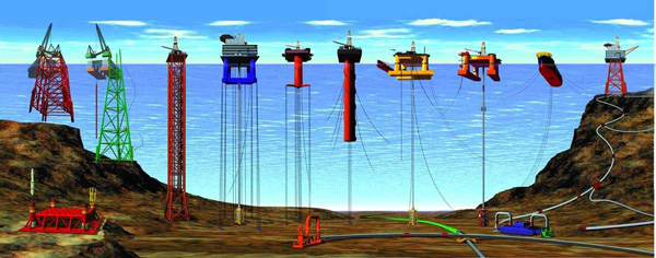
English: Types of Offshore Oil and Gas Structures
  • 1) & 2) Conventional fixed platforms (deepest: Shell’s Bullwinkle in 1991 at 412 m/1,353 ft GOM)
  • 3) Compliant tower (deepest: ChevronTexaco’s Petronius in 1998 at 534 m /1,754 ft GOM)
  • 4) & 5) Vertically moored tension leg and mini-tension leg platform (deepest: ConocoPhillips’ Magnolia in 2004 1,425 m/4,674 ft GOM)
  • 6) Spar (deepest: Dominion’s Devils Tower in 2004, 1,710 m/5,610 ft GOM)
  • 7) & 8) Semi-submersibles (deepest: Shell’s NaKika in 2003, 1920 m/6,300 ft GOM)
  • 9) Floating production, storage, and offloading facility (deepest: 2005, 1,345 m/4,429 ft Brazil)
  • 10) Sub-sea completion and tie-back to host facility (deepest: Shell’s Coulomb tie to NaKika 2004, 2,307 m/ 7,570 ft)
(Numbered from left to right; all records from 2005 data)
Deutsch: Arten von Öl- und Gasbohrinseln
  • 1) & 2) Feste Plattform (tiefste Einsatzstelle: „Bullwinkle“ (Shell) 1991 mit 412 m / 1.353 ft GOM)
  • 3) Turmplattform (tiefste Einsatzstelle: „Petronius“ (ChevronTexaco) 1998 mit 534 m / 1.754 ft GOM)
  • 4) & 5) TLP (für englisch Tension leg platform, wörtl. „Spannbein-Plattform“) (tiefste Einsatzstelle: „Magnolia“ (ConocoPhillips) 2004 mit 1.425 m / 4.674 ft GOM)
  • 6) Spierentonne (englisch Spar) (tiefste Einsatzstelle: Devils Tower (Dominion) in 2004, 1,710 m/5,610 ft GOM)
  • 7) & 8) Halbtaucherborinsel (englisch Semi-submersible rig) (tiefste Einsatzstelle: NaKika (Shell) 2003 mit 1.920 m / 6.300 ft GOM)
  • 9) Schwimmende Produktions- und Lagereinheit (englisch Floating Production Storage and Offloading Unit) (tiefste Einsatzstelle: „Brazil“ 2005 mit 1,345 m/4,429 ft)
  • 10) Completion-Plattform (tiefste Einsatzstelle: Schleppen der „Coulomb“ (Shell) nach Na Kika 2004, 2.307 m / 7.570 ft)
(von links nach rechts; alle Angaben bzgl. tiefsten Einsatzstellen Stand 2005, weitere Informationen in folgenden Artikeln:
  • Bohrinsel (Deutsch) Allgemeiner Artikel zur Bohrinsel (auch die Quelle für die meisten Übersetzungen oben, s. dafür Abschnitt „Bauarten“)
  • Hubinsel (Deutsch) Artikel zu Hubinseln, diese werden auch für Bohrplattformen eingesetzt (s. Abschnitt „Verwendung/Bohrplattformen“) und gehört zu den festen Plattformen.
Was mit dem Ausdruck ‚GOM‘ gemeint war, konnte während der Übersetzung nicht zweifelsfrei angenommen werden. Es wird angenommen, dass er für ‚Gulf of Mexico (deutsch ‚‘) steht. Sofern die Bedeutung geklärt werden konnte, bitte diesen Hinweis entfernen )
Dato Revised at la 15-a de decembro 2008
Fonto
Aŭtoro
  • Office of Ocean Exploration and Research
National Oceanic and Atmospheric Administration (NOAA), US Department of Commerce
  • Graphic originally developed and provided to NOAA by Oil States Industries, Inc., supplier of many of the technologies and connecting systems for these offshore platforms
Ceteraj versioj

Permesiloj:

Public domain
This image is in the public domain because it contains materials that originally came from the U.S. National Oceanic and Atmospheric Administration, taken or made as part of an employee's official duties.

العربية  čeština  Deutsch  Zazaki  English  español  eesti  suomi  français  hrvatski  magyar  italiano  日本語  한국어  македонски  മലയാളം  Plattdüütsch  Nederlands  polski  português  română  русский  sicilianu  slovenščina  Türkçe  Tiếng Việt  简体中文  繁體中文  +/−

Titoloj

Donu unulinian priskribon de la enhavo de ĉi tiu dosiero

Eroj prezentitaj en ĉi tiu dosiero

montras

image/jpeg

Dosierhistorio

Alklaku iun daton kaj horon por vidi kiel la dosiero tiam aspektis.

Dato/HoroBildetoGrandecojUzantoKomento
nun19:44, 25 okt. 2013Bildeto por versio ekde 19:44, 25 okt. 2013600 × 236 (97 KB)JaybearNumbers added;
17:56, 23 maj. 2010Bildeto por versio ekde 17:56, 23 maj. 2010600 × 236 (72 KB)Emerson7{{Information |Description = Types of offshore oil and gas structures incude: 1, 2) conventional fixed platforms (deepest: Shell’s Bullwinkle in 1991 at 412 m/1,353 ft GOM); 3) compliant tower (deepest: ChevronTexaco’s Petronius in 1998 at 534 m /

La jena paĝo ligas al ĉi tiu dosiero:

Suma uzado de la dosiero

La jenaj aliaj vikioj utiligas ĉi tiun dosieron: