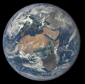
Dosiero:Africa and Europe from a Million Miles Away.png

Grandeco de ĉi antaŭvido: 604 × 600 rastrumeroj. Aliaj distingivoj: 242 × 240 rastrumeroj | 483 × 480 rastrumeroj | 773 × 768 rastrumeroj | 1 031 × 1 024 rastrumeroj | 1 780 × 1 768 rastrumeroj.
Bildo en pli alta difino ((1 780 × 1 768 rastrumeroj, grandeco de dosiero: 3,68 MB, MIME-tipo: image/png))
Dosierhistorio
Alklaku iun daton kaj horon por vidi kiel la dosiero tiam aspektis.
| Dato/Horo | Bildeto | Grandecoj | Uzanto | Komento | |
|---|---|---|---|---|---|
| nun | 13:09, 9 aŭg. 2015 |  | 1 780 × 1 768 (3,68 MB) | JorisvS | crop; there was too much black |
| 11:44, 8 aŭg. 2015 |  | 2 048 × 2 048 (2,98 MB) | ArionStar | Tight crop | |
| 02:56, 31 jul. 2015 |  | 1 700 × 1 700 (3,67 MB) | PhilipTerryGraham | Crop | |
| 17:30, 29 jul. 2015 |  | 2 048 × 2 048 (2,98 MB) | Originalwana | {{Information |Description ={{en|1=Africa is front and center in this image of Earth taken by a NASA camera on the Deep Space Climate Observatory (DSCOVR) satellite. The image, taken July 6 from a vantage point one million miles from Earth, was one... |
Dosiera uzado
La jena paĝo ligas al ĉi tiu dosiero:
Suma uzado de la dosiero
La jenaj aliaj vikioj utiligas ĉi tiun dosieron:
- Uzado en af.wikipedia.org
- Uzado en ar.wikipedia.org
- كوكب
- إفريقيا
- ويكيبيديا:صور مختارة/الفضاء والكون/نظرة إلى الخلف
- بوابة:علم الفلك/صورة مختارة
- ويكيبيديا:ترشيحات الصور المختارة/إفريقيا وأوروبا
- ويكيبيديا:صورة اليوم المختارة/سبتمبر 2018
- قالب:صورة اليوم المختارة/2018-09-07
- بوابة:علم الفلك/صورة مختارة/64
- جغرافيا إفريقيا
- ويكيبيديا:صورة اليوم المختارة/فبراير 2020
- قالب:صورة اليوم المختارة/2020-02-29
- ويكيبيديا:صورة اليوم المختارة/ديسمبر 2022
- قالب:صورة اليوم المختارة/2022-12-31
- Uzado en as.wikipedia.org
- Uzado en bcl.wikipedia.org
- Uzado en be-tarask.wikipedia.org
- Uzado en blk.wikipedia.org
- Uzado en ckb.wikipedia.org
- Uzado en crh.wikipedia.org
- Uzado en cv.wikipedia.org
- Uzado en de.wiktionary.org
- Uzado en el.wikipedia.org
- Uzado en el.wiktionary.org
- Uzado en en.wikipedia.org
- List of Solar System objects by size
- Wikipedia:Userboxes/Seasonal
- User:Kwamikagami/sandbox
- Talk:Earth/Archive 14
- User:Kazkaskazkasako/Books/Physical sciences
- User:Rfassbind/sandbox/Leadimage compilations
- Talk:Earth/Archive 15
- User:VGrigas (WMF)/Quality Media
- User:Jmaxx37
- Wikipedia:Wikipedia Signpost/2018-10-28/Gallery
- Wikipedia:Wikipedia Signpost/Single/2018-10-28
- User:Applekle/sandbox
- User:Double sharp/Largest Solar System objects
- User:Maria DDias/TWA/Earth/2
- User:Jmaxx37/Userboxes
- User:Jmaxx37/Userboxes/Fav-holiday Earth Day
- Wikipedia talk:WikiProject Userboxes/New Userboxes/Archive 38
- User:Roger Capybara6
- User:KeroseneLover100/sandbox/sandbox
- Uzado en en.wikiversity.org
- Uzado en es.wikipedia.org
- Uzado en eu.wikipedia.org
Vidi plian ĝeneralan uzadon de ĉi tiu dosiero.


