
Dosiero:Earthquake wave paths.svg

Bildo en pli alta difino (SVG-dosiero, 300 × 250 rastrumeroj, grandeco de dosiero: 24 KB)
| Jen dosiero de la Wikimedia-Komunejo. La priskribo en ties priskriba paĝo estas montrata suben.
|
| Ĉi tio estas modifita bildo, kio signifas, ke ĝi ekestis per cifereca aliigo de la origina versio. Modifoj: Vectorized. La originaĵo videblas ĉi tie: Earthquake wave paths.gif. La modifojn faris Hardwigg.
|
| Priskribo |
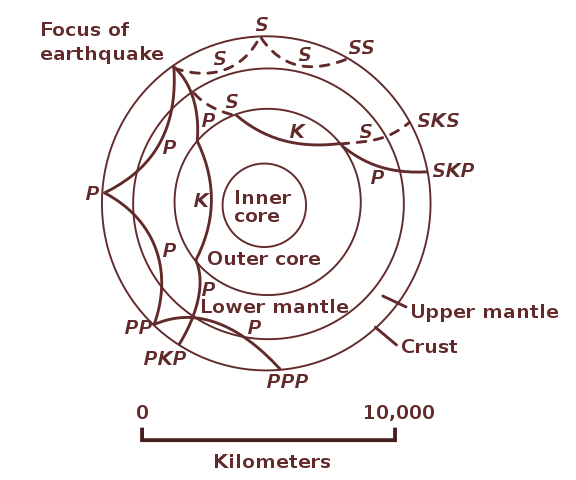
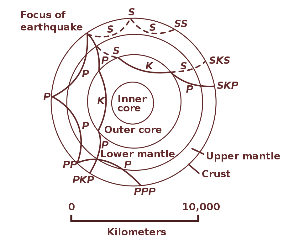
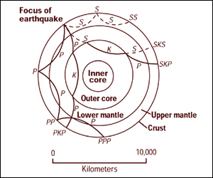
Cross section of the whole Earth, showing the complexity of paths of earthquake waves. The paths curve because the different rock types found at different depths change the speed at which the waves travel. Solid lines marked P are compressional waves; dashed lines marked S are shear waves. S waves do not travel through the core but may be converted to compressional waves (marked K) on entering the core (PKP, SKS). Waves may be reflected at the surface (PP, PPP, SS). Seismographs detect the various types of waves. Analysis of such records reveals structures within the Earth. |
|||
| Fonto | http://pubs.usgs.gov/gip/interior/fig2.gif ; original upload in english wikipedia, 15 April 2005 by SEWilco | |||
| Aŭtoro | SEWilco | |||
| Permeso (Reuzo de la dosiero) |
|
|||
| Ceteraj versioj |
Derivaĵoj de ĉi tiu dosiero: |
Dosierhistorio
Alklaku iun daton kaj horon por vidi kiel la dosiero tiam aspektis.
| Dato/Horo | Bildeto | Grandecoj | Uzanto | Komento | |
|---|---|---|---|---|---|
| nun | 02:21, 31 okt. 2010 | | 300 × 250 (24 KB) | Hardwigg | {{Information |Description=Cross section of the whole Earth, showing the complexity of paths of earthquake waves. The paths curve because the different rock types found at different depths change the speed at w |
Dosiera uzado
La jena paĝo ligas al ĉi tiu dosiero:
Suma uzado de la dosiero
La jenaj aliaj vikioj utiligas ĉi tiun dosieron:
- Uzado en ast.wikipedia.org
- Uzado en beta.wikiversity.org
- Uzado en bg.wikipedia.org
- Uzado en bh.wikipedia.org
- Uzado en bn.wikipedia.org
- Uzado en ca.wikipedia.org
- Uzado en da.wikipedia.org
- Uzado en el.wikipedia.org
- Uzado en en.wikipedia.org
- Uzado en en.wikibooks.org
- Uzado en en.wikiquote.org
- Uzado en en.wikiversity.org
- Uzado en es.wikipedia.org
- Uzado en fr.wikipedia.org
- Uzado en gl.wikipedia.org
- Uzado en hu.wikipedia.org
- Uzado en it.wikipedia.org
- Uzado en ja.wikipedia.org
- Uzado en ko.wikipedia.org
- Uzado en mk.wikipedia.org
- Uzado en ml.wikipedia.org
- Uzado en ms.wikipedia.org
- Uzado en nl.wikipedia.org
- Uzado en pl.wikipedia.org
- Uzado en pt.wikipedia.org
- Uzado en sl.wikipedia.org
- Uzado en sr.wikipedia.org
- Uzado en sv.wikipedia.org
- Uzado en th.wikipedia.org
Vidi plian ĝeneralan uzadon de ĉi tiu dosiero.