
Dosiero:Fonseca gulf.jpg

Grandeco de ĉi antaŭvido: 615 × 600 rastrumeroj. Aliaj distingivoj: 246 × 240 rastrumeroj | 492 × 480 rastrumeroj | 640 × 624 rastrumeroj.
Bildo en pli alta difino ((640 × 624 rastrumeroj, grandeco de dosiero: 109 KB, MIME-tipo: image/jpeg))
| Jen dosiero de la Wikimedia-Komunejo. La priskribo en ties priskriba paĝo estas montrata suben.
|
Resumo
| Priskribo |
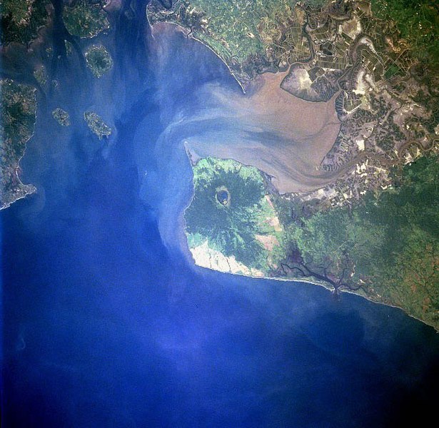
Gulf of Fonseca, El Salvador, Honduras, Nicaragua |
| Dato | |
| Fonto | eol.jsc.nasa.gov |
| Aŭtoro | NASA |
| Ceteraj versioj |
.jpg)
Permesiloj:
| La ĉi-supra dosiero estas publika havaĵo, ĉar ĝi apartenas al NASA. La kopirajta regularo de NASA asertas, ke "ĉiuj dokumentoj de NASA estas publika havaĵo, se ne estas donata kontraŭa deklaro". | ||
 |
Atentu:
|
Dosierhistorio
Alklaku iun daton kaj horon por vidi kiel la dosiero tiam aspektis.
| Dato/Horo | Bildeto | Grandecoj | Uzanto | Komento | |
|---|---|---|---|---|---|
| nun | 09:40, 22 nov. 2022 | | 640 × 624 (109 KB) | SteinsplitterBot | Bot: Image rotated by 270° |
| 04:10, 10 dec. 2005 |  | 631 × 640 (110 KB) | Thuresson | Gulf of Fonseca, El Salvador, Honduras, Nicaragua - July 1997 *Image courtesy of the Image Science & Analysis Laboratory, NASA Johnson Space Center. *Source: [http://eol.jsc.nasa.gov/sseop/EFS/photoinfo.pl?PHOTO=STS094-723-83 eol.jsc.nasa.gov] *Photo #: |
Dosiera uzado
La jena paĝo ligas al ĉi tiu dosiero:
Suma uzado de la dosiero
La jenaj aliaj vikioj utiligas ĉi tiun dosieron:
- Uzado en de.wikipedia.org
- Uzado en el.wikipedia.org
- Uzado en en.wikipedia.org
- Uzado en es.wikipedia.org
- Uzado en fr.wikipedia.org
- Uzado en gl.wikipedia.org
- Uzado en it.wikipedia.org
- Uzado en ja.wikipedia.org
- Uzado en lt.wikipedia.org
- Uzado en nl.wikipedia.org
- Uzado en pl.wikipedia.org
- Uzado en pt.wikipedia.org
- Uzado en ru.wikipedia.org
- Uzado en sk.wikipedia.org
- Uzado en uk.wikipedia.org
- Uzado en www.wikidata.org