
Dosiero:Kenmare Stone Circle - geograph.org.uk - 1444795.jpg
Jen estas la maksimuma distingivo de la supra bildo.
Kenmare_Stone_Circle_-_geograph.org.uk_-_1444795.jpg ((640 × 419 rastrumeroj, grandeco de dosiero: 93 KB, MIME-tipo: image/jpeg))
| Jen dosiero de la Wikimedia-Komunejo. La priskribo en ties priskriba paĝo estas montrata suben.
|
Resumo
| Priskribo |
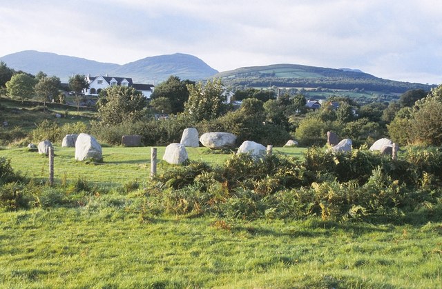
English: Kenmare Stone Circle This stone circle is about 300 metres west of the town centre of Kenmare in an area known as The Shrubberies. It comprises a ring of 15 free-standing stones, 13 upright and 2 prostrate, with a diameter of about 16 metres. These circles are thought to form part of the funerary or ritual tradition of the Bronze Age, dating from between about 2400 BC and 500 BC. |
| Dato | |
| Fonto | From geograph.org.uk |
| Aŭtoro | Nigel Cox |
| Atribuite (required by the license) | Nigel Cox / Kenmare Stone Circle / |
| Pozicio de la fotilo | | Tiu cxi bildo kaj pliaj sur OpenStreetMap |
|---|
_heading:315.00&language=eo)
| Pozicio de la objekto | | Tiu cxi bildo kaj pliaj sur OpenStreetMap |
|---|
_heading:315.00&language=eo)
Permesiloj:

|
This image was taken from the Geograph project collection. See this photograph's page on the Geograph website for the photographer's contact details. The copyright on this image is owned by Nigel Cox and is licensed for reuse under the Creative Commons Attribution-ShareAlike 2.0 license.
|
Ĉi tiu dosiero estas disponebla laŭ la permesilo Krea Komunaĵo Atribuite-Samkondiĉe 2.0 Ĝenerala.
Atribuite: Nigel Cox
- Vi rajtas:
- kunhavigi – kopii, distribui kaj publikigi la verkon
- aliigi – modifi, adapti, kompletigi, transformi, uzi la tutan verkon aŭ ties partojn, memstare aŭ en aliaj verkoj
- La verko rajtas esti kunhavigata nur:
- atribuite – Vi devas atribui aŭtorecon, liveri ligilon al la permesilo kaj marki ĉu ŝanĝoj estis faritaj. Faru tion en aprobinda maniero, tamen ne sugestante, ke permesinto aprobas vin aŭ vian uzon.
- samkondiĉe – Se vi rekombinas la verkon, transformas ĝin aŭ kreas devenaĵon bazitan sur ĝi, vi rajtas distribui la rezultan verkon nur laŭ la sama aŭ kongrua permesilo kompare kun ĉi tiu.
Dosierhistorio
Alklaku iun daton kaj horon por vidi kiel la dosiero tiam aspektis.
| Dato/Horo | Bildeto | Grandecoj | Uzanto | Komento | |
|---|---|---|---|---|---|
| nun | 02:18, 2 mar. 2011 | | 640 × 419 (93 KB) | GeographBot | == {{int:filedesc}} == {{Information |description={{en|1=Kenmare Stone Circle This stone circle is about 300 metres west of the town centre of Kenmare in an area known as The Shrubberies. It comprises a ring of 15 free-standing stones, 13 upright and 2 pr |
Dosiera uzado
La jenaj paĝoj ligas al ĉi tiu dosiero:
Suma uzado de la dosiero
La jenaj aliaj vikioj utiligas ĉi tiun dosieron:
- Uzado en ca.wikipedia.org
- Uzado en de.wikipedia.org
- Uzado en de.wikivoyage.org
- Uzado en en.wikipedia.org
- Uzado en www.wikidata.org