
Dosiero:Map of USA TX.svg

Grando de tiu PNG antaŭprezento de tiu SVGa dosiero: 286 × 186 rastrumeroj. Aliaj distingivoj: 320 × 208 rastrumeroj | 640 × 416 rastrumeroj | 1 024 × 666 rastrumeroj | 1 280 × 832 rastrumeroj | 2 560 × 1 665 rastrumeroj.
Bildo en pli alta difino (SVG-dosiero, 286 × 186 rastrumeroj, grandeco de dosiero: 167 KB)
| Jen dosiero de la Wikimedia-Komunejo. La priskribo en ties priskriba paĝo estas montrata suben.
|
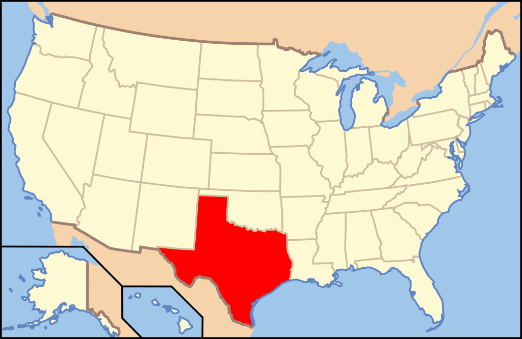
Clickable version
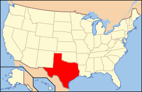
| Priskribo | Map of USA with Texas highlighted | ||||||||
| Dato | see file history below. | ||||||||
| Fonto | own work by uploader, based on Image:Map of USA without state names.svg | ||||||||
| Aŭtoro |
This version: uploader Base versions this one is derived from: originally created by en:User:Wapcaplet |
||||||||
| Permeso (Reuzo de la dosiero) |
Ĉi tiu dosiero estas disponebla laŭ la permesilo Krea Komunaĵo Atribuite 2.0 Ĝenerala.
|
||||||||
| Ceteraj versioj | image:Map of USA with state names.svg |

Dosierhistorio
Alklaku iun daton kaj horon por vidi kiel la dosiero tiam aspektis.
| Dato/Horo | Bildeto | Grandecoj | Uzanto | Komento | |
|---|---|---|---|---|---|
| nun | 10:36, 9 jun. 2006 | | 286 × 186 (167 KB) | Huebi~commonswiki | {{Information| |Description=Map of USA with Texas highlighted |other_versions=image:Map of USA with state names.svg }} Category:Maps of the United States Category:Maps of Texas Category:SVG maps {{GFDL-en}}{{cc-by-2.0}}{{cc-by-sa-1.0}}{ |
Dosiera uzado
Pli ol 100 paĝoj ligas al tiu ĉi dosiero. La jena listo montras unuajn 100 paĝon kun nur tiu ĉi dosiero. La plena listo estas atingebla.
- Kantono Anderson (Teksaso)
- Kantono Andrews (Teksaso)
- Kantono Angelina (Teksaso)
- Kantono Archer (Teksaso)
- Kantono Armstrong (Teksaso)
- Kantono Atascosa (Teksaso)
- Kantono Austin (Teksaso)
- Kantono Bailey (Teksaso)
- Kantono Bandera (Teksaso)
- Kantono Bastrop
- Kantono Baylor (Teksaso)
- Kantono Bee (Teksaso)
- Kantono Bell (Teksaso)
- Kantono Bexar
- Kantono Blanco (Teksaso)
- Kantono Borden (Teksaso)
- Kantono Bosque (Teksaso)
- Kantono Bowie (Teksaso)
- Kantono Brazoria (Teksaso)
- Kantono Brazos (Teksaso)
- Kantono Brewster (Teksaso)
- Kantono Briscoe (Teksaso)
- Kantono Brooks (Teksaso)
- Kantono Brown (Teksaso)
- Kantono Burleson (Teksaso)
- Kantono Burnet (Teksaso)
- Kantono Caldwell (Teksaso)
- Kantono Calhoun (Teksaso)
- Kantono Callahan (Teksaso)
- Kantono Cameron (Teksaso)
- Kantono Camp (Teksaso)
- Kantono Carson (Teksaso)
- Kantono Cass (Teksaso)
- Kantono Castro (Teksaso)
- Kantono Chambers (Teksaso)
- Kantono Cherokee (Teksaso)
- Kantono Childress (Teksaso)
- Kantono Clay (Teksaso)
- Kantono Cochran (Teksaso)
- Kantono Coke (Teksaso)
- Kantono Coleman (Teksaso)
- Kantono Collin (Teksaso)
- Kantono Collingsworth (Teksaso)
- Kantono Colorado (Teksaso)
- Kantono Comal (Teksaso)
- Kantono Comanche (Teksaso)
- Kantono Concho (Teksaso)
- Kantono Cooke (Teksaso)
- Kantono Coryell (Teksaso)
- Kantono Cottle (Teksaso)
- Kantono Crane (Teksaso)
- Kantono Crockett (Teksaso)
- Kantono Crosby (Teksaso)
- Kantono Culberson (Teksaso)
- Kantono Dallam (Teksaso)
- Kantono Dallas (Teksaso)
- Kantono Dawson (Teksaso)
- Kantono DeWitt (Teksaso)
- Kantono Deaf Smith (Teksaso)
- Kantono Delta (Teksaso)
- Kantono Denton (Teksaso)
- Kantono Dickens (Teksaso)
- Kantono Dimmit (Teksaso)
- Kantono Donley (Teksaso)
- Kantono Duval (Teksaso)
- Kantono Eastland (Teksaso)
- Kantono Ector (Teksaso)
- Kantono Edwards (Teksaso)
- Kantono El Paso (Teksaso)
- Kantono Ellis (Teksaso)
- Kantono Erath (Teksaso)
- Kantono Falls (Teksaso)
- Kantono Fannin (Teksaso)
- Kantono Fayette (Teksaso)
- Kantono Fisher (Teksaso)
- Kantono Floyd (Teksaso)
- Kantono Foard (Teksaso)
- Kantono Fort Bend (Teksaso)
- Kantono Franklin (Teksaso)
- Kantono Freestone (Teksaso)
- Kantono Frio (Teksaso)
- Kantono Gaines (Teksaso)
- Kantono Galveston (Teksaso)
- Kantono Garza (Teksaso)
- Kantono Gillespie (Teksaso)
- Kantono Glasscock (Teksaso)
- Kantono Goliad (Teksaso)
- Kantono Gonzales (Teksaso)
- Kantono Hall (Teksaso)
- Kantono Hansford (Teksaso)
- Kantono Hardeman (Teksaso)
- Kantono Henderson (Teksaso)
- Kantono Hidalgo (Teksaso)
- Kantono Houston (Teksaso)
- Kantono Hudspeth (Teksaso)
- Kantono Jeff Davis (Teksaso)
- Kantono Leon (Teksaso)
- Kantono Parker (Teksaso)
- Kantono Reeves (Teksaso)
- Kantono Rusk (Teksaso)
Vidi pliajn ligilojn al ĉi tiu dosiero.
Suma uzado de la dosiero
La jenaj aliaj vikioj utiligas ĉi tiun dosieron:
- Uzado en af.wikipedia.org
- Uzado en als.wikipedia.org
- Uzado en ang.wikipedia.org
- Uzado en an.wikipedia.org
- Uzado en ay.wikipedia.org
- Uzado en azb.wikipedia.org
- Uzado en az.wikipedia.org
- Uzado en az.wiktionary.org
- Uzado en bat-smg.wikipedia.org
- Uzado en ba.wikipedia.org
- Uzado en be-tarask.wikipedia.org
- Uzado en bg.wikipedia.org
- Анджелина (окръг, Тексас)
- Арансас (окръг, Тексас)
- Остин (окръг, Тексас)
- Бий (окръг, Тексас)
- Беър (окръг, Тексас)
- Бланко (окръг, Тексас)
- Бордън (окръг, Тексас)
- Боски (окръг, Тексас)
- Боуи (окръг, Тексас)
- Бразория
- Брискоу (окръг, Тексас)
- Бразос (окръг, Тексас)
- Брукс (окръг, Тексас)
- Браун (окръг, Тексас)
- Бърлсън (окръг, Тексас)
- Бърнит (окръг, Тексас)
- Колдуел (окръг, Тексас)
- Калхун (окръг, Тексас)
- Калахан (окръг, Тексас)
- Камерън (окръг, Тексас)
- Кемп (окръг, Тексас)
- Карсън (окръг, Тексас)
- Кас (окръг, Тексас)
- Кастро (окръг, Тексас)
- Чеймбърс (окръг, Тексас)
- Чероки (окръг, Тексас)
- Клей (окръг, Тексас)
- Кокран (окръг, Тексас)
- Коук (окръг)
- Колман (окръг, Тексас)
- Колин (окръг, Тексас)
- Колингсуърт (окръг, Тексас)
- Колорадо (окръг, Тексас)
- Комал (окръг, Тексас)
- Команчи (окръг, Тексас)
- Кончо (окръг, Тексас)
Vidi plian ĝeneralan uzadon de ĉi tiu dosiero.