
Dosiero:New England (1).jpg

Grandeco de ĉi antaŭvido: 691 × 599 rastrumeroj. Aliaj distingivoj: 277 × 240 rastrumeroj | 553 × 480 rastrumeroj | 885 × 768 rastrumeroj | 1 180 × 1 024 rastrumeroj | 2 000 × 1 735 rastrumeroj.
Bildo en pli alta difino ((2 000 × 1 735 rastrumeroj, grandeco de dosiero: 3,5 MB, MIME-tipo: image/jpeg))
| Jen dosiero de la Wikimedia-Komunejo. La priskribo en ties priskriba paĝo estas montrata suben.
|
.jpg)
Resumo
| Priskribo |
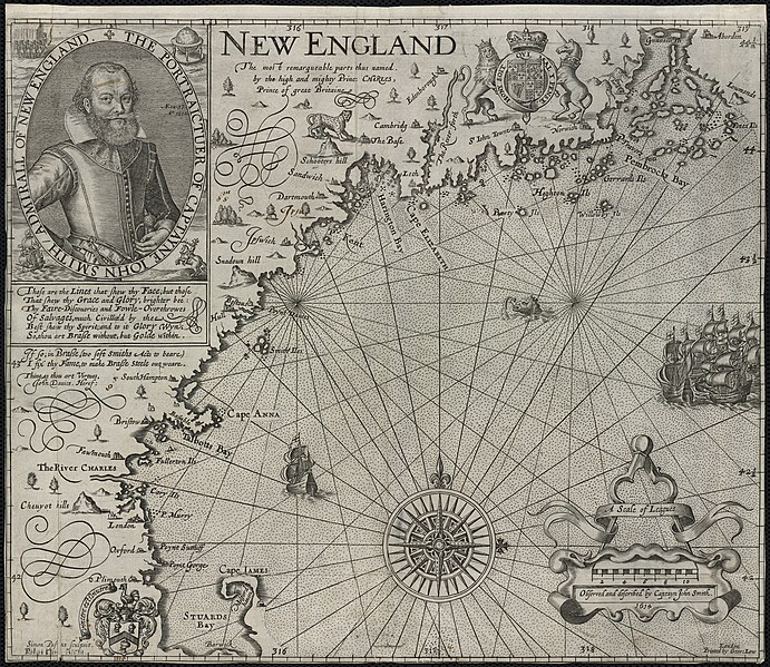
Zoom into this map at maps.bpl.org. Author: Smith, John Publisher: Printed by Geor. Low Date: [1624] Location: New England Scale: Scale [ca. 1:1,120,000] Call Number: G3720 1624.S6 Based on John Smiths 1614 voyage along the New England coast, this is the first printed map devoted specifically to this region. It is also the first to use the name “New England”for an area that had up until this time been called “North Virginia.”Smith, who is more commonly associated with the founding of Virginia, was commissioned to survey the coastline north of New York in preparation for the settlement of another English colony. This map was used to guide the Pilgrims to Plymouth and also led John Winthrop to the Charles River in 1629. |
| Dato | |
| Fonto |
|
| Aŭtoro | http://maps.bpl.org |
Permesiloj:
Ĉi tiu dosiero estas disponebla laŭ la permesilo Krea Komunaĵo Atribuite 2.0 Ĝenerala.
- Vi rajtas:
- kunhavigi – kopii, distribui kaj publikigi la verkon
- aliigi – modifi, adapti, kompletigi, transformi, uzi la tutan verkon aŭ ties partojn, memstare aŭ en aliaj verkoj
- La verko rajtas esti kunhavigata nur:
- atribuite – Vi devas atribui aŭtorecon, liveri ligilon al la permesilo kaj marki ĉu ŝanĝoj estis faritaj. Faru tion en aprobinda maniero, tamen ne sugestante, ke permesinto aprobas vin aŭ vian uzon.
| This image, originally posted to Flickr, was reviewed on December 30, 2011 by the administrator or reviewer File Upload Bot (Magnus Manske), who confirmed that it was available on Flickr under the stated license on that date. |
Dosierhistorio
Alklaku iun daton kaj horon por vidi kiel la dosiero tiam aspektis.
| Dato/Horo | Bildeto | Grandecoj | Uzanto | Komento | |
|---|---|---|---|---|---|
| nun | 20:10, 30 dec. 2011 | | 2 000 × 1 735 (3,5 MB) | File Upload Bot (Magnus Manske) | {{Information |Description=Zoom into [http://maps.bpl.org/id/10050 this map] at [http://maps.bpl.org maps.bpl.org]. '''Author:''' Smith, John '''Publisher:''' Printed by Geor. Low '''Date:''' [1624] '''Location:''' New England '''Scale:''' Scale [ca. 1:1 |
Dosiera uzado
La jena paĝo ligas al ĉi tiu dosiero:
Suma uzado de la dosiero
La jenaj aliaj vikioj utiligas ĉi tiun dosieron:
- Uzado en en.wikipedia.org
.jpg)