
Dosiero:ORD airport map.PNG

Grandeco de ĉi antaŭvido: 391 × 600 rastrumeroj. Aliaj distingivoj: 156 × 240 rastrumeroj | 313 × 480 rastrumeroj | 807 × 1 238 rastrumeroj.
Bildo en pli alta difino ((807 × 1 238 rastrumeroj, grandeco de dosiero: 247 KB, MIME-tipo: image/png))
| Jen dosiero de la Wikimedia-Komunejo. La priskribo en ties priskriba paĝo estas montrata suben.
|

|
File:ORD Airport Diagram.svg estas vektora versio de ĉi tiu bildo. Ĝi estu uzata anstataŭ ĉi tiu rastruma bildo, se ĝi ne estas malpli bonkvalita.
File:ORD airport map.PNG → File:ORD Airport Diagram.svg
Pliajn informojn vidu ĉe Help:SVG. |
 |

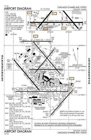
Airport diagram of O'Hare International Airport
This image or file is a work of a Federal Aviation Administration employee, taken or made as part of that person's official duties. As a work of the U.S. federal government, the image is in the public domain in the United States.
|
 |
Dosierhistorio
Alklaku iun daton kaj horon por vidi kiel la dosiero tiam aspektis.
| Dato/Horo | Bildeto | Grandecoj | Uzanto | Komento | |
|---|---|---|---|---|---|
| nun | 22:50, 12 jul. 2012 | | 807 × 1 238 (247 KB) | Phongn | Update to 28 Jun 2012 version. |
| 01:59, 24 okt. 2010 |  | 807 × 1 238 (306 KB) | Mareklug | Reverted to version as of 01:52, 24 October 2010 | |
| 01:58, 24 okt. 2010 |  | 807 × 1 238 (306 KB) | Mareklug | newer, 2nd attempt. | |
| 01:52, 24 okt. 2010 |  | 807 × 1 238 (306 KB) | Mareklug | newer, larger version (Oct 21, 2010) | |
| 16:40, 7 maj. 2010 |  | 387 × 594 (98 KB) | Spartan S58 | Showing the shortening of 32L'14R, and changed taxi from P to U. | |
| 23:59, 18 feb. 2009 |  | 774 × 1 188 (129 KB) | Mahahahaneapneap | Compressed | |
| 03:54, 11 dec. 2008 |  | 774 × 1 188 (257 KB) | Jalentz | Updated to include opening of runway 9L/27R November 2008 | |
| 19:33, 22 jul. 2007 |  | 1 570 × 2 285 (305 KB) | Mareklug | Updated (version from 5 July 2007 showing redesignated runway 10/28 which used to be 9R/27L) airport diagram of O'Hare International Airport {{PD-USGov-FAA}} | |
| 21:15, 6 jan. 2006 |  | 733 × 1 133 (134 KB) | Cmprince | Aiport diagram of O'Hare International Airport {{PD-USGov-FAA}} |
Dosiera uzado
Neniu paĝo ligas al ĉi tiu dosiero.