
Dosiero:Population density of Ireland map2002.svg

Grando de tiu PNG antaŭprezento de tiu SVGa dosiero: 480 × 600 rastrumeroj. Aliaj distingivoj: 192 × 240 rastrumeroj | 384 × 480 rastrumeroj | 614 × 768 rastrumeroj | 819 × 1 024 rastrumeroj | 1 638 × 2 048 rastrumeroj.
Bildo en pli alta difino (SVG-dosiero, 800 × 1 000 rastrumeroj, grandeco de dosiero: 621 KB)
| Jen dosiero de la Wikimedia-Komunejo. La priskribo en ties priskriba paĝo estas montrata suben.
|
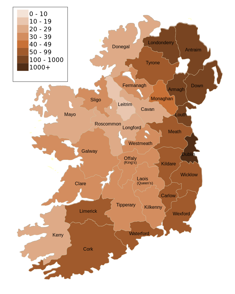
| Priskribo | Map of Ireland's population density (people per km2). Based upon Republic of Ireland - 2002 Census results. |
| Dato | (UTC) |
| Fonto | |
| Aŭtoro |
|
| Ceteraj versioj | Derivaĵoj de ĉi tiu dosiero: Population density of Ireland map2002 RU.svg |
| Ĉi tio estas modifita bildo, kio signifas, ke ĝi ekestis per cifereca aliigo de la origina versio. Modifoj: Map of Ireland's population density (people per km2). Based upon Republic of Ireland - 2002 Census results.. La originaĵo videblas ĉi tie: Ireland complete.svg. La modifojn faris The Illusional Ministry.
|
Mi, la posedanto de la aŭtorrajto por ĉi tiu verko, ĉi-maniere publikigas tiun laŭ la jena permesilo:
| Mi, la posedanto de la aŭtorrajto por ĉi tiu verko, liberigas ĝin tutmonde kiel publikan havaĵon. En iuj landoj tio povas esti laŭleĝe neebla; en tiu okazo: Mi rajtigas ĉiun ajn uzi ĉi tiun verkon por ajna celo, sen iuj ajn kondiĉoj, krom se tiuj kondiĉoj estas postulataj per leĝo. |
Originala alŝutada protokolo
This image is a derivative work of the following images:
- File:Ireland_complete.svg licensed with PD-self
- 2007-06-23T17:06:44Z Future Perfect at Sunrise 800x1000 (594536 Bytes) {{Information |Description= |Source=self-made |Date= |Author= [[User:Future Perfect at Sunrise|Future Perfect at Sunrise]] }}
- 2007-06-23T16:45:52Z Future Perfect at Sunrise 800x1000 (590003 Bytes) {{Information |Description= |Source=self-made |Date= |Author= [[User:Future Perfect at Sunrise|Future Perfect at Sunrise]] }}
- 2007-06-23T16:35:48Z Future Perfect at Sunrise 2000x2500 (606764 Bytes) {{Information |Description=SVG map of Ireland. |Source=self-made |Date=23 June 2007 |Author= [[User:Future Perfect at Sunrise|Future Perfect at Sunrise]] }} Note: the SVG code contains separate levels showing boundaries and
Uploaded with derivativeFX
Dosierhistorio
Alklaku iun daton kaj horon por vidi kiel la dosiero tiam aspektis.
| Dato/Horo | Bildeto | Grandecoj | Uzanto | Komento | |
|---|---|---|---|---|---|
| nun | 14:30, 17 okt. 2009 | | 800 × 1 000 (621 KB) | The Illusional Ministry | Dublin now in black text |
| 14:27, 17 okt. 2009 |  | 800 × 1 000 (621 KB) | The Illusional Ministry | {{Information |Description=Map of Ireland's population density (people per km2). Based upon Republic of Ireland - 2002 Census results. |Source=*File:Ireland_complete.svg |Date=2009-10-17 14:25 (UTC) |Author=*File:Ireland_complete.svg: '''Futur |
Dosiera uzado
Neniu paĝo ligas al ĉi tiu dosiero.
Suma uzado de la dosiero
La jenaj aliaj vikioj utiligas ĉi tiun dosieron:
- Uzado en de.wikipedia.org
- Uzado en gv.wikipedia.org
- Uzado en he.wikipedia.org
- Uzado en hu.wikipedia.org
- Uzado en kn.wikipedia.org
- Uzado en sd.wikipedia.org
- Uzado en te.wikipedia.org