
Dosiero:Dalsfjorden Rivedal.jpg

Bildo en pli alta difino ((2 394 × 1 107 rastrumeroj, grandeco de dosiero: 1,47 MB, MIME-tipo: image/jpeg))
| Jen dosiero de la Wikimedia-Komunejo. La priskribo en ties priskriba paĝo estas montrata suben.
|
Resumo
| Priskribo |
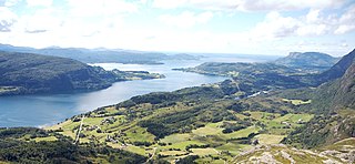
Norsk nynorsk: The image is cropped by me, User:Jorunn Neset ca. midt i biletet, på andre sida av fjorden, er Straumsnes. Innom Straumsnes heiter fjorden Dalsfjorden, utom heiter han Vilnesfjorden. Landet på andre sidan av fjorden er i Fjaler kommune, medan det på den sida der fotografen er er Askvoll. Gardane nedom fjellet/åsen fotografen er på er i Rivedal. Vegen ein ser gå ned mot fjorden til venstre i biletet er Riksveg 609. Vegen ein kan sjå konturane av på andre sida av fjorden er Fylkesveg 394 i Sogn og Fjordane. Vatnet til høgre i biletet er Bakkevatnet. In English (Translation by MyLegAlta) : The point near the centre of the picture, on the other side of the fjord, is Straumsnes. Beyond Straumsnes, the fjord is called Vilnesfjorden, and inland from that point, it is named Dalsfjord. The municipality of Fjaler is on the other side of the fjord, while the photo was taken from the municipality of Askvoll.The farms seen blow the mountain form the which the photo was taken are located in Rivedal. The road on the left side of the picture going down towards the fjord is Riksveg 609. The contour of Fylkesveg 394 can be seen on the other side of the fjord. The body of water on the right of the picture is called Bakkevatnet. |
| Dato | |
| Fonto | Flickr.com |
| Aŭtoro | Jarkko Laine |
Permesiloj:
- Vi rajtas:
- kunhavigi – kopii, distribui kaj publikigi la verkon
- aliigi – modifi, adapti, kompletigi, transformi, uzi la tutan verkon aŭ ties partojn, memstare aŭ en aliaj verkoj
- La verko rajtas esti kunhavigata nur:
- atribuite – Vi devas atribui aŭtorecon, liveri ligilon al la permesilo kaj marki ĉu ŝanĝoj estis faritaj. Faru tion en aprobinda maniero, tamen ne sugestante, ke permesinto aprobas vin aŭ vian uzon.
| This image, originally posted to Flickr, was reviewed on 1 December 2008 by the administrator or reviewer Mitchazenia, who confirmed that it was available on Flickr under the stated license on that date. |
Dosierhistorio
Alklaku iun daton kaj horon por vidi kiel la dosiero tiam aspektis.
| Dato/Horo | Bildeto | Grandecoj | Uzanto | Komento | |
|---|---|---|---|---|---|
| nun | 20:33, 1 dec. 2008 | | 2 394 × 1 107 (1,47 MB) | Jorunn | {{Information |Description={{nn|1=The image is cropped by me, User:Jorunn Neset ca. midt i biletet, på andre sida av fjorden, er Straumsnes. Innom Straumsnes heiter fjorden Dalsfjorden, utom heiter han Vilnesfjorden. Landet på andre sidan av fjorde |
Dosiera uzado
La jena paĝo ligas al ĉi tiu dosiero:
Suma uzado de la dosiero
La jenaj aliaj vikioj utiligas ĉi tiun dosieron:
- Uzado en ca.wikipedia.org
- Uzado en ceb.wikipedia.org
- Uzado en da.wikipedia.org
- Uzado en en.wikipedia.org
- Uzado en es.wikipedia.org
- Uzado en eu.wikipedia.org
- Uzado en fi.wikipedia.org
- Uzado en fr.wikipedia.org
- Uzado en it.wikipedia.org
- Uzado en nn.wikipedia.org
- Uzado en no.wikipedia.org
- Uzado en pl.wikipedia.org
- Uzado en ro.wikipedia.org
- Uzado en ru.wikipedia.org
- Uzado en sl.wikipedia.org
- Uzado en sv.wikipedia.org
- Uzado en www.wikidata.org
- Uzado en zh.wikipedia.org