
Dosiero:Ethnic map of 11th century.jpg
Grandeco de ĉi antaŭvido: 800 × 522 rastrumeroj. Aliaj distingivoj: 320 × 209 rastrumeroj | 640 × 418 rastrumeroj | 806 × 526 rastrumeroj.
Bildo en pli alta difino ((806 × 526 rastrumeroj, grandeco de dosiero: 236 KB, MIME-tipo: image/jpeg))
| Jen dosiero de la Wikimedia-Komunejo. La priskribo en ties priskriba paĝo estas montrata suben.
|
Resumo
| Priskribo |
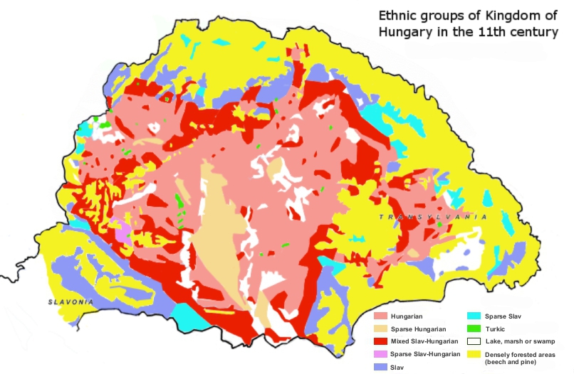
English: Ethnic map of Kingdom of Hungary in the 11th century based on place-names. ..."Although the historical study of place-names is not practised to the same extent in all countries, it is a recognized branch of historiography. It encompasses the etymology of geographical names as well as cultural and chronological variations in the naming of places. To facilitate their study of Hungarian place-names, István Kniezsa and Géza Bárczi developed an analytical framework that blends etymology, typology, and chronology. The validity of this triple approach has been amply demonstrated, thanks not only to the expertise of the two scholars but also to the peculiarity of Hungarian toponymy, which is readily distinguishable from that of any other culture. Most of the early Hungarian toponyms are derived from the names of people, clans, and ethnic groups, or from occupations, and used in the nominative case singular (e.g. Árpád, Megyer, Cseh [Czech], Ács [carpenter]). This type of toponymy appears in the earliest documents, dating from around 1000 AD. The pattern holds well into the 13th century — until the 1220s in western Hungary, and the 1270s in the eastern parts, including Transylvania..."(László Makkai, TRANSYLVANIA IN THE MEDIEVAL HUNGARIAN KINGDOM (896–1526), IN: Köpeczi Béla (General Editor), HISTORY OF TRANSYLVANIA Volume I. From the Beginnings to 1606, Distributed by Columbia University Press, New York, 2001, ISBN 0-88033-479-7)
Magyar: MAGYARORSZÁG NÉPEI A XI. SZÁZADBA http://mek.oszk.hu/09100/09175/html/4.html
A magyar törzsek a X.század végén érkeztek a politikailag akkor még alig szervezett, többnyire gyér, szláv-avar népesség lakta, új hazájába. Honfoglaló őseink a XI.század során akkori félnomád életmódjuknak leginkább megfelelő, korábbi hazájuk természeti környezetére emlékeztető erdős-(főként tölgyes) sztyeppen, stratégiai fekvésű folyóvölgyekben és alacsony dombvidéki területeken települtek le. Az általában a legeltetésre alkalmatlan, gyér aljnövényzetű bükkösök határáig terjedő, korai magyar településterületet többnyire az évi 600 mm-nél kevesebb csapadék és a lösz nagyobb mennyiségű előfordulása jellemezte (Kniezsa I. 1938, Mendöl T. 1947). A X. században a magyarok legnagyobb sűrűségben -- a hadászatilag fontos gyepűkapukon kívül -- a 900 nyarán elfoglalt Dunántúlt, azon belül is az Óbuda-Csepel-Fehérvár-Pécs közötti fejedelmi szállásterület övezetét lakták. Ez főként -- a stratégiai szempontok mellett -- a honfoglalók félnomád életmódjának leginkább megfelelő változatos és eléggé tagolt domborzatnak volt köszönhető (vö. Mendöl T. 1947). Ugyanakkor a honfoglalók etnikai területe az alföldi árterekre, homokvidékekre és a hegy-, dombvidéki zártabb erdőségekre többnyire nem terjedt ki. A nyugati magyar kalandozó csapatok augsburgi vereségét (955), a gyepűvédelmi rendszer megerősítését követően a XI. század végére a magyar etnikai terület kiterjedése a következő volt: északon a Pozsony - Galgóc - Garamszentbenedek - Ipoly-medence - a gömöri Pelsőc - a sáros megyei Eperjes-Sóvár - Tőketerebes - Ungvár - Beregszász vonal; keleten az Erdélyi-medencét (főként a Mezőséget, a Küküllők vidékét és a Maros középső szakaszának környékét) és a Nagy Alföldet kitöltve a hegyvidék lába; délen hozzávetőleg a Mura - Dráva - Duna vonala annyi eltéréssel, hogy a Szerémség északi fele és a Vuka vidéke magyar többségűnek számított; nyugaton Fertő - Sopron - Kőszeg - Pinkamellék vonala (Kniezsa I. 1938, 1939) http://mnynk.unideb.hu/publikaciok/hi_tv_szazadok.pdf |
| Dato | |
| Fonto |
Propra verko Sources:
|
| Aŭtoro | Fakirbakir |
Permesiloj:
Mi, la posedanto de la aŭtorrajto por ĉi tiu verko, ĉi-maniere publikigas tiun laŭ la jena permesilo:
Ĉi tiu dosiero estas disponebla laŭ la permesilo Krea Komunaĵo Atribuite-Samkondiĉe 3.0 Neadaptita.
- Vi rajtas:
- kunhavigi – kopii, distribui kaj publikigi la verkon
- aliigi – modifi, adapti, kompletigi, transformi, uzi la tutan verkon aŭ ties partojn, memstare aŭ en aliaj verkoj
- La verko rajtas esti kunhavigata nur:
- atribuite – Vi devas atribui aŭtorecon, liveri ligilon al la permesilo kaj marki ĉu ŝanĝoj estis faritaj. Faru tion en aprobinda maniero, tamen ne sugestante, ke permesinto aprobas vin aŭ vian uzon.
- samkondiĉe – Se vi rekombinas la verkon, transformas ĝin aŭ kreas devenaĵon bazitan sur ĝi, vi rajtas distribui la rezultan verkon nur laŭ la sama aŭ kongrua permesilo kompare kun ĉi tiu.
Dosierhistorio
Alklaku iun daton kaj horon por vidi kiel la dosiero tiam aspektis.
| Dato/Horo | Bildeto | Grandecoj | Uzanto | Komento | |
|---|---|---|---|---|---|
| nun | 22:22, 22 jan. 2013 | | 806 × 526 (236 KB) | Fakirbakir | minor changes (according to Kniezsa's map) |
| 17:15, 21 jan. 2013 |  | 806 × 526 (235 KB) | Fakirbakir | More understandable, repair, + I remove "Hungarian perspective" because other editors convinced me, science is universal, a scientific statement should not depend on the nationality of the scholar. | |
| 10:35, 21 jan. 2013 |  | 806 × 526 (232 KB) | Fakirbakir | More neutral / "Hungarian perspective" | |
| 22:08, 19 jan. 2013 |  | 806 × 526 (226 KB) | Fakirbakir | User created page with UploadWizard |
Dosiera uzado
La jena paĝo ligas al ĉi tiu dosiero:
Suma uzado de la dosiero
La jenaj aliaj vikioj utiligas ĉi tiun dosieron:
- Uzado en en.wikipedia.org
- Uzado en hu.wikipedia.org
- Uzado en it.wikipedia.org
- Uzado en uk.wikipedia.org