
Dosiero:Great Bitter Lake, Egypt.jpg

Grandeco de ĉi antaŭvido: 800 × 533 rastrumeroj. Aliaj distingivoj: 320 × 213 rastrumeroj | 640 × 427 rastrumeroj | 1 024 × 683 rastrumeroj | 1 440 × 960 rastrumeroj.
Bildo en pli alta difino ((1 440 × 960 rastrumeroj, grandeco de dosiero: 323 KB, MIME-tipo: image/jpeg))
| Jen dosiero de la Wikimedia-Komunejo. La priskribo en ties priskriba paĝo estas montrata suben.
|
Resumo
| Priskribo |
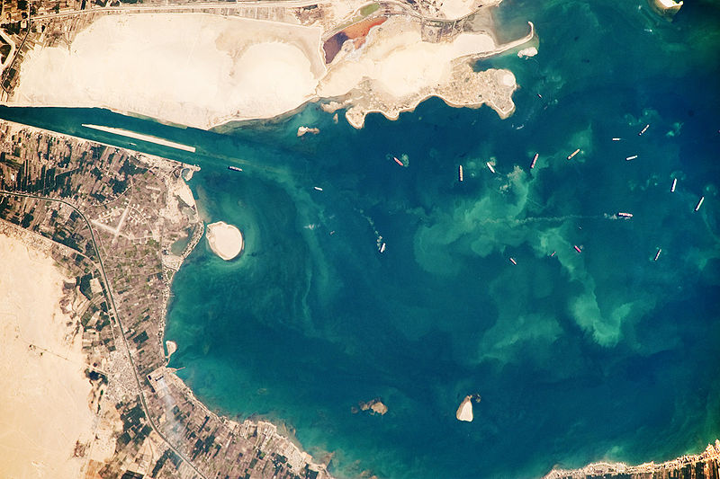
English: Several ships, some under power and some anchored, are visible at image right. Large expanses of white and tan sandy sediments at image left and top attest to the desert conditions surrounding the lake. Located at the approximate midpoint of the Suez Canal, Great Bitter Lake is now filled with water derived from both the Red and Mediterranean Seas, and this steady influx of water balances the water lost to evaporation. The town of Fayid (also spelled as Fayed), visible along the western shore of the lake (bottom) is a tourist destination for residents of Cairo, particularly in the summer months.
|
||||||||||||||||||||||||||||||||||||||||||||||||||
| Dato | |||||||||||||||||||||||||||||||||||||||||||||||||||
| Fonto | NASA Earth Observatory | ||||||||||||||||||||||||||||||||||||||||||||||||||
| Aŭtoro | This image was taken by the NASA Expedition 20 crew. | ||||||||||||||||||||||||||||||||||||||||||||||||||
This photograph was acquired with a Nikon D3 digital camera fitted with an 800 mm lens, and is provided by the ISS Crew Earth Observations experiment and Image Science & Analysis Laboratory, Johnson Space Centre.
Permesiloj:
| La ĉi-supra dosiero estas publika havaĵo, ĉar ĝi apartenas al NASA. La kopirajta regularo de NASA asertas, ke "ĉiuj dokumentoj de NASA estas publika havaĵo, se ne estas donata kontraŭa deklaro". | ||
 |
Atentu:
|
Dosierhistorio
Alklaku iun daton kaj horon por vidi kiel la dosiero tiam aspektis.
| Dato/Horo | Bildeto | Grandecoj | Uzanto | Komento | |
|---|---|---|---|---|---|
| nun | 15:23, 26 okt. 2009 | | 1 440 × 960 (323 KB) | Originalwana | {{Information |Description={{en|1=Several ships, some under power and some anchored, are visible at image right. Large expanses of white and tan sandy sediments at image left and top attest to the desert cond |
Dosiera uzado
La jenaj paĝoj ligas al ĉi tiu dosiero:
Suma uzado de la dosiero
La jenaj aliaj vikioj utiligas ĉi tiun dosieron:
- Uzado en af.wikipedia.org
- Uzado en ar.wikipedia.org
- Uzado en arz.wikipedia.org
- Uzado en ca.wikipedia.org
- Uzado en en.wikipedia.org
- Uzado en es.wikipedia.org
- Uzado en eu.wikipedia.org
- Uzado en fi.wikipedia.org
- Uzado en he.wikipedia.org
- Uzado en id.wikipedia.org
- Uzado en kk.wikipedia.org
- Uzado en la.wikipedia.org
- Uzado en mt.wikipedia.org
- Uzado en my.wikipedia.org
- Uzado en pl.wikipedia.org
- Uzado en pt.wikipedia.org
- Uzado en simple.wikipedia.org
- Uzado en tr.wikipedia.org
- Uzado en zh.wikipedia.org