
Dosiero:Isle of Man map-en.svg

Grando de tiu PNG antaŭprezento de tiu SVGa dosiero: 654 × 600 rastrumeroj. Aliaj distingivoj: 262 × 240 rastrumeroj | 524 × 480 rastrumeroj | 838 × 768 rastrumeroj | 1 117 × 1 024 rastrumeroj | 2 234 × 2 048 rastrumeroj | 1 200 × 1 100 rastrumeroj.
Bildo en pli alta difino (SVG-dosiero, 1 200 × 1 100 rastrumeroj, grandeco de dosiero: 686 KB)
| Jen dosiero de la Wikimedia-Komunejo. La priskribo en ties priskriba paĝo estas montrata suben.
|

Resumo
| Priskribo |
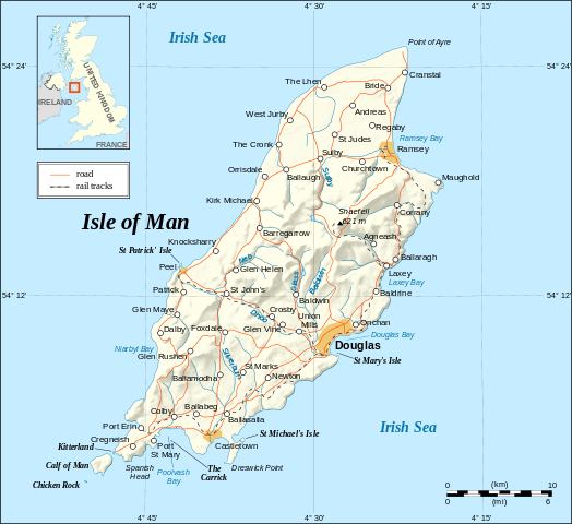
English: Map in English of the Isle of Man.
Note : The shaded relief is a raster image embedded in the SVG. Français : Carte en anglais de l'Île de Man. Note : Le relief ombré est une image bitmap incrustée dans le fichier SVG. UTM projection; WGS84 datum; shaded relief (composite image of N-W, W and N lightning positions); |
||
| Dato | |||
| Fonto |
Own work ;
|
||
| Aŭtoro | Eric Gaba (Sting - fr:Sting) | ||
| Permeso (Reuzo de la dosiero) |
|
||
| Ceteraj versioj |
[]
|


|
Ĉi tiu SVG-dosiero enhavas enkonstruitan tekston, kiu estas tradukebla en vian lingvon uzante ilon por traduki SVG-dosierojn aŭ ajnan kapablan SVG-redaktilon. Por pliaj informoj vidu: Pri tradukado de SVG-dosieroj. |
Permesiloj:
Mi, la posedanto de la aŭtorrajto por ĉi tiu verko, ĉi-maniere publikigas ĝin laŭ la jenaj permesiloj:

|
Estas permesite kopii, disdoni kaj/aŭ redakti ĉi tiun dokumenton, sen senŝanĝaj sekcioj, sen antaŭkovrilaj kaj sen dorskovrilaj tekstoj, laŭ la kondiĉoj de la Permesilo GNU por Liberaj Dokumentoj, Versio 1.2 aŭ ajna pli nova versio eldonita de la Free Software Foundation; sen Senŝanĝaj Sekcioj, Antaŭovrilaj Tekstoj aŭ Malantaŭkovrilaj Tekstoj. Kopio de la permesilo estas inkluzivita en la sekcio titolita GNU Free Documentation License. |
| Ĉi tiu dosiero estas disponebla laŭ la permesilo Krea Komunaĵo Atribuite-Samkondiĉe 3.0 Neadaptita. | ||
| ||
| Ĉi tiu permesila etikedo estis aldonita al la dosiero kiel parto de la permesila aktualigo por GFDL. |
Ĉi tiu dosiero estas disponebla laŭ la permesiloj Krea Komunaĵo Atribuite-Samkondiĉe 2.5 Ĝenerala, 2.0 Ĝenerala kaj 1.0 Ĝenerala.
- Vi rajtas:
- kunhavigi – kopii, distribui kaj publikigi la verkon
- aliigi – modifi, adapti, kompletigi, transformi, uzi la tutan verkon aŭ ties partojn, memstare aŭ en aliaj verkoj
- La verko rajtas esti kunhavigata nur:
- atribuite – Vi devas atribui aŭtorecon, liveri ligilon al la permesilo kaj marki ĉu ŝanĝoj estis faritaj. Faru tion en aprobinda maniero, tamen ne sugestante, ke permesinto aprobas vin aŭ vian uzon.
- samkondiĉe – Se vi rekombinas la verkon, transformas ĝin aŭ kreas devenaĵon bazitan sur ĝi, vi rajtas distribui la rezultan verkon nur laŭ la sama aŭ kongrua permesilo kompare kun ĉi tiu.
Vi povas elekti la permesilon preferatan.
Dosierhistorio
Alklaku iun daton kaj horon por vidi kiel la dosiero tiam aspektis.
| Dato/Horo | Bildeto | Grandecoj | Uzanto | Komento | |
|---|---|---|---|---|---|
| nun | 14:38, 4 sep. 2008 | | 1 200 × 1 100 (686 KB) | Sting | New standard colors |
| 23:03, 21 maj. 2007 |  | 1 200 × 1 100 (786 KB) | Sting | {{Information |Description=Map in English of the Isle of Man |Source=Own work ;<br/>Background map and shaded relief : [http://www2.jpl.nasa.gov/srtm NASA Shuttle Radar Topography Mission] (SRTM3 v.2) (public domain) edited with [http: |
Dosiera uzado
La jena paĝo ligas al ĉi tiu dosiero:
Suma uzado de la dosiero
La jenaj aliaj vikioj utiligas ĉi tiun dosieron:
- Uzado en ca.wikipedia.org
- Uzado en cv.wikipedia.org
- Uzado en cy.wikipedia.org
- Uzado en de.wikipedia.org
- Uzado en en.wikipedia.org
- Uzado en en.wikibooks.org
- Uzado en en.wikisource.org
- Uzado en es.wikipedia.org
- Uzado en es.wiktionary.org
- Uzado en fa.wikipedia.org
- Uzado en frr.wikipedia.org
- Uzado en gag.wikipedia.org
- Uzado en ga.wikipedia.org
- Uzado en gv.wikipedia.org
- Uzado en ha.wikipedia.org
- Uzado en hr.wikipedia.org
- Uzado en ja.wikipedia.org
- Uzado en kw.wikipedia.org
- Uzado en lt.wikipedia.org
- Uzado en mi.wikipedia.org
- Uzado en mr.wikipedia.org
- Uzado en nl.wikipedia.org
- Uzado en sk.wikipedia.org
- Uzado en sl.wikipedia.org
- Uzado en stq.wikipedia.org
- Uzado en tr.wikipedia.org
- Uzado en tr.wiktionary.org
- Uzado en vi.wikipedia.org
- Uzado en vls.wikipedia.org
- Uzado en zh.wikipedia.org