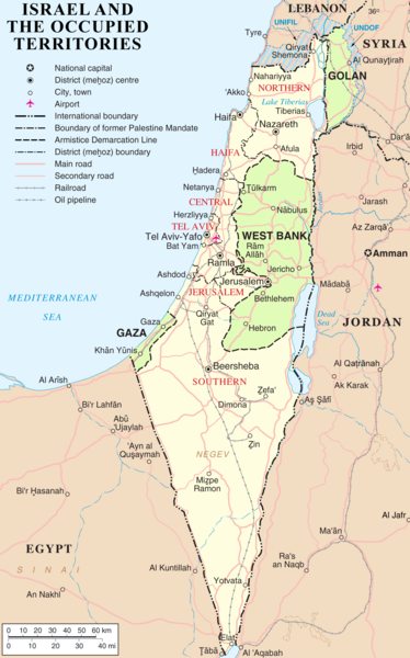
Dosiero:Israel and occupied territories map.png

Grandeco de ĉi antaŭvido: 374 × 600 rastrumeroj. Aliaj distingivoj: 150 × 240 rastrumeroj | 299 × 480 rastrumeroj | 479 × 768 rastrumeroj | 639 × 1 024 rastrumeroj | 1 428 × 2 289 rastrumeroj.
Bildo en pli alta difino ((1 428 × 2 289 rastrumeroj, grandeco de dosiero: 266 KB, MIME-tipo: image/png))
Dosierhistorio
Alklaku iun daton kaj horon por vidi kiel la dosiero tiam aspektis.
| Dato/Horo | Bildeto | Grandecoj | Uzanto | Komento | |
|---|---|---|---|---|---|
| nun | 03:50, 14 maj. 2018 |  | 1 428 × 2 289 (266 KB) | Nableezy | Reverted to version as of 23:21, 5 March 2018 (UTC) restore, your changes are incorrect, make a new title if you want |
| 18:52, 10 mar. 2018 |  | 559 × 721 (212 KB) | Eric's son | No, this one is outdated. If i make another map, ill have to go to many different langauges wikis and replace every single map. Reverted to version as of 21:53, 26 February 2018 (UTC) | |
| 23:21, 5 mar. 2018 |  | 1 428 × 2 289 (266 KB) | Nableezy | Reverted to version as of 22:49, 29 March 2007 (UTC) make a different upload, dont replace every other map with this one | |
| 21:53, 26 feb. 2018 |  | 559 × 721 (212 KB) | Eric's son | Adding relevant updates (evacuated UN zones), clear colored borders explained in legend. | |
| 22:49, 29 mar. 2007 |  | 1 428 × 2 289 (266 KB) | ChrisO | ||
| 21:06, 27 mar. 2007 |  | 1 428 × 2 289 (257 KB) | ChrisO | == Summary == Map of Israel, the [http://en.wikipedia.org/wiki/Palestinian_territories Palestinian territories] (West Bank and Gaza Strip), the Golan Heights, and neighbouring countries. Modified and adapted from http://www.un.org/Depts/Ca |
Dosiera uzado
La jena paĝo ligas al ĉi tiu dosiero:
Suma uzado de la dosiero
La jenaj aliaj vikioj utiligas ĉi tiun dosieron:
- Uzado en ar.wikipedia.org
- Uzado en arz.wikipedia.org
- Uzado en ast.wikipedia.org
- Uzado en az.wikipedia.org
- Uzado en bn.wikipedia.org
- Uzado en ca.wikipedia.org
- Irredemptisme
- Resolució 259 del Consell de Seguretat de les Nacions Unides
- Resolució 641 del Consell de Seguretat de les Nacions Unides
- Resolució 694 del Consell de Seguretat de les Nacions Unides
- Resolució 726 del Consell de Seguretat de les Nacions Unides
- Resolució 799 del Consell de Seguretat de les Nacions Unides
- Uzado en cs.wikipedia.org
- Uzado en de.wikipedia.org
- Uzado en de.wikinews.org
- Uzado en en.wikipedia.org
- Six-Day War
- Israeli-occupied territories
- List of territorial disputes
- List of irredentist claims or disputes
- Borders of Israel
- Talk:Borders of Israel
- Expansionism
- Wikipedia:Notice board for Israel-related topics/Archive2
- Wikipedia talk:WikiProject Israel/Archive 4
- Talk:List of territories governed by the United Nations
- Wikipedia:Graphics Lab/Map workshop/Archive/Feb 2014
- Boycotts of Israel
- User:Falcaorib
- Uzado en en.wikiquote.org
- Uzado en es.wikipedia.org
- Uzado en fa.wikipedia.org
- Uzado en fi.wikipedia.org
- Uzado en fr.wikipedia.org
- Uzado en he.wikipedia.org
- Uzado en hr.wikipedia.org
- Uzado en hy.wikipedia.org
- Uzado en id.wikipedia.org
- Uzado en it.wikipedia.org
- Uzado en ms.wikipedia.org
- Uzado en no.wikipedia.org
- Uzado en pl.wikipedia.org
- Uzado en pl.wikimedia.org
- Uzado en pnb.wikipedia.org
- Uzado en ru.wikipedia.org
- Uzado en sh.wikipedia.org
- Uzado en simple.wikipedia.org
Vidi plian ĝeneralan uzadon de ĉi tiu dosiero.


