
Dosiero:Lizars Mexico & Guatimala 1836 UTA (detail of Texas).jpg
Grandeco de ĉi antaŭvido: 694 × 600 rastrumeroj. Aliaj distingivoj: 278 × 240 rastrumeroj | 555 × 480 rastrumeroj | 889 × 768 rastrumeroj | 1 185 × 1 024 rastrumeroj | 1 357 × 1 173 rastrumeroj.
Bildo en pli alta difino ((1 357 × 1 173 rastrumeroj, grandeco de dosiero: 983 KB, MIME-tipo: image/jpeg))
| Jen dosiero de la Wikimedia-Komunejo. La priskribo en ties priskriba paĝo estas montrata suben.
|
Resumo
| Titolo |
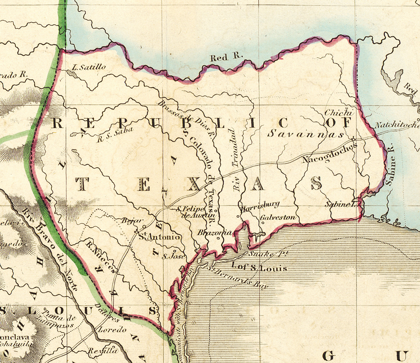
English: Mexico & Guatimala [sic] |
||||||||||||||||||||||||||
| Priskribo |
English: Shortly after Texas declared its independence from Mexico in 1836, the Edinburgh painter, engraver, printer, cartographer, lithographer, and publisher William Home Lizars (1788-1859), brother of Daniel Lizars II (1793-1875), updated the original plate for the map of Mexico & Guatemala to include the new republic. He added the towns of Galveston, Harrisburg, Brazoria, S. Felipe de Austin (although recently destroyed), Bejar, and "S. Jose" (probably intended to represent Goliad). Lizars made no further improvements to the general cartographic shape of the republic except to show the Nueces River as the southern boundary and the western boundary curving to the point where the 100th meridian strikes the Red River. The map continues to show Mexico's administrative districts as Spanish Intendencies (Intendencias) and Internal Provinces (Provincias Internas) over fifteen years since Mexico's independence. |
||||||||||||||||||||||||||
| Dato | ĉirkaŭ 1836 | ||||||||||||||||||||||||||
| Fonto | UTA Libraries Cartographic Connections: mapo / text | ||||||||||||||||||||||||||
| Kreinto |
|
||||||||||||||||||||||||||
| Akirmaniero |
English: The University of Texas at Arlington Libraries Special Collections, Gift of Lewis & Virginia Buttery |
||||||||||||||||||||||||||
| Geotemporal data | |||||||||||||||||||||||||||
| Map location | Teksaso | ||||||||||||||||||||||||||
| Georeferencing | If inappropriate please set warp_status = skip to hide. | ||||||||||||||||||||||||||
| Bibliographic data | |||||||||||||||||||||||||||
| Loko de eldonigo | Edinburgo | ||||||||||||||||||||||||||
| Eldonejo |
|
||||||||||||||||||||||||||
| Archival data | |||||||||||||||||||||||||||
| Kolekto |
|
||||||||||||||||||||||||||
| Dimensioj | alto: 42 cm; larĝo: 51,5 cm | ||||||||||||||||||||||||||
| Medio | kolorigita engraving sur papero | ||||||||||||||||||||||||||
| artwork-references |
Worms, Laurence; Ashley Baynton-Williams (2011) British Map Engravers, Londono: Rare Book Society, pp. 406–409 |
||||||||||||||||||||||||||
| Ceteraj versioj | |||||||||||||||||||||||||||

.jpg)
Permesiloj:

|
This file was provided to Wikimedia Commons by the University of Texas at Arlington Libraries as part of a cooperation project. The University of Texas at Arlington Libraries is part of the University of Texas at Arlington, a public research university located in Arlington, Texas.
|
|
Tiu ĉi verko estas publika havaĵo en tiuj landoj, kies kopirajtado validas por longo de vivo plus 100 jaroj aŭ malpli. This work is in the public domain in the United States because it was published (or registered with the U.S. Copyright Office) before January 1, 1929. | |
| Estis konkludite ke uzon de ĉi tiu dosiero limigas neniu konata aŭtorrajta leĝo, kio inkluzivas ĉiujn rilatajn kaj apudajn rajtojn. | |
Dosierhistorio
Alklaku iun daton kaj horon por vidi kiel la dosiero tiam aspektis.
| Dato/Horo | Bildeto | Grandecoj | Uzanto | Komento | |
|---|---|---|---|---|---|
| nun | 15:18, 13 jul. 2019 | | 1 357 × 1 173 (983 KB) | Michael Barera | File:Lizars Mexico & Guatimala 1836 UTA.jpg cropped 79 % horizontally, 78 % vertically using CropTool with precise mode. |
Dosiera uzado
La jena paĝo ligas al ĉi tiu dosiero:
Suma uzado de la dosiero
La jenaj aliaj vikioj utiligas ĉi tiun dosieron:
- Uzado en azb.wikipedia.org
- Uzado en ca.wikipedia.org
- Uzado en cv.wikipedia.org
- Uzado en en.wikipedia.org
- Uzado en fa.wikipedia.org
- Uzado en it.wikipedia.org
- Uzado en ja.wikipedia.org
- Uzado en ko.wikipedia.org
- Uzado en mk.wikipedia.org
- Uzado en mzn.wikipedia.org
- Uzado en pl.wikipedia.org
- Uzado en pt.wikipedia.org
- Uzado en sv.wikipedia.org
- Uzado en th.wikipedia.org
- Uzado en yi.wikipedia.org
- Uzado en zh-min-nan.wikipedia.org
.jpg)