
Dosiero:MSH82 st helens spirit lake reflection 05-19-82.jpg

Grandeco de ĉi antaŭvido: 800 × 544 rastrumeroj. Aliaj distingivoj: 320 × 218 rastrumeroj | 640 × 435 rastrumeroj | 1 024 × 697 rastrumeroj | 1 280 × 871 rastrumeroj | 2 560 × 1 742 rastrumeroj | 4 734 × 3 221 rastrumeroj.
Bildo en pli alta difino ((4 734 × 3 221 rastrumeroj, grandeco de dosiero: 1,1 MB, MIME-tipo: image/jpeg))
| Jen dosiero de la Wikimedia-Komunejo. La priskribo en ties priskriba paĝo estas montrata suben.
|
Resumo
| Priskribo |
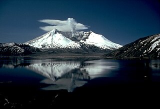
English: Mount St. Helens and the devastated area is now within the 110,000-acre Mount St. Helens National Volcanic Monument, under jurisdiction of the United States Forest Service. Visitor centers, interpretive areas, and trails are being established as thousands of tourists, students, and scientists visit the monument daily. Mount St. Helens is once again considered to be one of the most beautiful and interesting of the Cascade volcanic peaks. |
|||
| Dato | ||||
| Fonto |
CVO Photo Archives Mount St. Helens, Washington Before, During, and After May 18, 1980 |
|||
| Aŭtoro | Lyn Topinka | |||
| Permeso (Reuzo de la dosiero) |
|
Dosierhistorio
Alklaku iun daton kaj horon por vidi kiel la dosiero tiam aspektis.
| Dato/Horo | Bildeto | Grandecoj | Uzanto | Komento | |
|---|---|---|---|---|---|
| nun | 17:54, 28 nov. 2007 | | 4 734 × 3 221 (1,1 MB) | CarolSpears | |
| 06:02, 9 aŭg. 2005 |  | 2 935 × 1 996 (832 KB) | Complex01 | USGS photo of Mt. Saint Helens. '''Caption''': Mount St. Helens and the devastated area is now within the 110,000-acre Mount St. Helens National Volcanic Monument, under jurisdiction of the United States Forest Service. Visitor centers, interpretive area |
Dosiera uzado
La jena paĝo ligas al ĉi tiu dosiero:
Suma uzado de la dosiero
La jenaj aliaj vikioj utiligas ĉi tiun dosieron:
- Uzado en ca.wikipedia.org
- Uzado en cs.wikipedia.org
- Uzado en da.wikipedia.org
- Uzado en en.wikipedia.org
- Uzado en en.wikivoyage.org
- Uzado en es.wikipedia.org
- Uzado en fi.wikipedia.org
- Uzado en fr.wikipedia.org
- Uzado en fr.wikibooks.org
- Uzado en fr.wikiversity.org
- Uzado en he.wikipedia.org
- Uzado en he.wikivoyage.org
- Uzado en hr.wikipedia.org
- Uzado en hu.wikipedia.org
- Uzado en it.wikipedia.org
- Uzado en ja.wikipedia.org
- Uzado en no.wikipedia.org
- Uzado en ro.wikipedia.org
- Uzado en sh.wikipedia.org
- Uzado en sk.wikipedia.org
- Uzado en sr.wikipedia.org
- Uzado en sv.wikipedia.org
- Uzado en uk.wikipedia.org
- Uzado en www.wikidata.org
- Uzado en zh.wikipedia.org