
Dosiero:Map Kingdom of Westphalia.jpg
Jen estas la maksimuma distingivo de la supra bildo.
Map_Kingdom_of_Westphalia.jpg ((348 × 409 rastrumeroj, grandeco de dosiero: 68 KB, MIME-tipo: image/jpeg))
| Jen dosiero de la Wikimedia-Komunejo. La priskribo en ties priskriba paĝo estas montrata suben.
|
Resumo
| Priskribo |
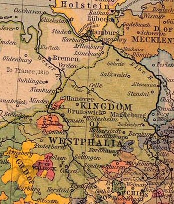
Nederlands: Koninkrijk Westfalen |
||||||||||||||||||||||
| Dato | |||||||||||||||||||||||
| Fonto | From The Historical Atlas by William R. Shepherd, 1926. | ||||||||||||||||||||||
| Aŭtoro |
|
||||||||||||||||||||||
| Permeso (Reuzo de la dosiero) |
PCL states map is PD | ||||||||||||||||||||||
Permesiloj:
Tiu ĉi verko estas publika havaĵo en tiuj landoj, kies kopirajtado validas por longo de vivo plus 80 jaroj aŭ malpli. | |
| Estis konkludite ke uzon de ĉi tiu dosiero limigas neniu konata aŭtorrajta leĝo, kio inkluzivas ĉiujn rilatajn kaj apudajn rajtojn. | |
This work is in the public domain because it was published in the United States between 1929 and 1963, and although there may or may not have been a copyright notice, the copyright was not renewed. For further explanation, see Commons:Hirtle chart and the copyright renewal logs. Note that it may still be copyrighted in jurisdictions that do not apply the rule of the shorter term for US works (depending on the date of the author's death), such as Canada (70 years p.m.a.), Mainland China (50 years p.m.a., not Hong Kong or Macao), Germany (70 years p.m.a.), Mexico (100 years p.m.a.), Switzerland (70 years p.m.a.), and other countries with individual treaties.
|
 |
Originala alŝutada protokolo
- Originally from nl.wikipedia; description page is/was here.
(All user names refer to nl.wikipedia)
- 2004-08-16 09:49 Känsterle 348×409×8 (69732 bytes) Koninkrijk Westfalen - vrij te gebruiken voor educatieve doeleinden - http://www.lib.utexas.edu/maps/historical/
Map of the principality (later free state) of Lippe 1815–1945. From German Wikipedia and according to information there "Gemeinfrei" = public domain. {{PD-user|Störfix}}
Dosierhistorio
Alklaku iun daton kaj horon por vidi kiel la dosiero tiam aspektis.
| Dato/Horo | Bildeto | Grandecoj | Uzanto | Komento | |
|---|---|---|---|---|---|
| nun | 09:38, 4 mar. 2007 | | 348 × 409 (68 KB) | SieBot | {{Information |Description=Koninkrijk Westfalen {{PD-PCL|central_europe_1812.jpg|historical/shepherd/}} |Source=Originally from [http://nl.wikipedia.org nl.wikipedia]; description page is/was [http://nl.wikipedia.org/w/index.php?title=Image%3AKWestfale |
Dosiera uzado
La jena paĝo ligas al ĉi tiu dosiero:
Suma uzado de la dosiero
La jenaj aliaj vikioj utiligas ĉi tiun dosieron:
- Uzado en ca.wikipedia.org
- Uzado en el.wikipedia.org
- Uzado en et.wikipedia.org
- Uzado en fa.wikipedia.org
- Uzado en he.wikipedia.org
- Uzado en id.wikipedia.org
- Uzado en it.wikipedia.org
- Uzado en ro.wikipedia.org
- Uzado en sr.wikipedia.org
- Uzado en zh.wikipedia.org