
Dosiero:Mount Mazama eruption timeline.PNG
Bildo en pli alta difino ((250 × 841 rastrumeroj, grandeco de dosiero: 187 KB, MIME-tipo: image/png))
| Jen dosiero de la Wikimedia-Komunejo. La priskribo en ties priskriba paĝo estas montrata suben.
|
Resumo
| Priskribo |
|
| Fonto | http://pubs.usgs.gov/fs/2002/fs092-02/ (saved as PNG) |
| Aŭtoro | U.S. GEOLOGICAL SURVEY and the NATIONAL PARK SERVICE |
| Ceteraj versioj |
    |

|
Tiu ĉi bildo geology respektive ĉiuj bildoj en tiu ĉi artikolo aŭ kategorio prefere estu rekreata(j) kiel vektora grafikaĵo en la formato SVG. Vektoraj formatoj por grafikaĵoj havas multajn avantaĝojn, detaloj troveblas anglalingve en la komuneja artikolo Commons:Media for cleanup. Se vi havas aŭ kreas SVG-version de tiu ĉi bildo, bonvolu alŝuti ĝin al la vikipedia komunejo. Post tiu ago, ĉi tiu ŝablono en la bildpaĝo estas anstataŭigenda per la ŝablono {{vector version available|nova dosiera nomo.svg}}.
|
Permesiloj:
This image is in the public domain in the United States because it only contains materials that originally came from the United States Geological Survey, an agency of the United States Department of the Interior. For more information, see the official USGS copyright policy.
|
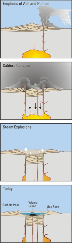
Crater Lake is an example, it is located in Oregen and was made from a valcano, making a caldera.
Dosierhistorio
Alklaku iun daton kaj horon por vidi kiel la dosiero tiam aspektis.
| Dato/Horo | Bildeto | Grandecoj | Uzanto | Komento | |
|---|---|---|---|---|---|
| nun | 05:24, 29 mar. 2006 | 250 × 841 (187 KB) | Jkelly | Source: http://pubs.usgs.gov/fs/2002/fs092-02/ (saved as PNG) Author: U.S. GEOLOGICAL SURVEY and the NATIONAL PARK SERVICE Description: <blockquote>Cataclysmic eruption to present. Eruptions of ash and pumice: The cataclysmic eruption started from a ve |
Dosiera uzado
La jena paĝo ligas al ĉi tiu dosiero:
Suma uzado de la dosiero
La jenaj aliaj vikioj utiligas ĉi tiun dosieron:
- Uzado en af.wikipedia.org
- Uzado en an.wikipedia.org
- Uzado en ar.wikipedia.org
- Uzado en ast.wikipedia.org
- Uzado en br.wikipedia.org
- Uzado en ce.wikipedia.org
- Uzado en cy.wikipedia.org
- Uzado en de.wikipedia.org
- Uzado en en.wikipedia.org
- Uzado en en.wikiversity.org
- Uzado en es.wikipedia.org
- Uzado en fa.wikipedia.org
- Uzado en fi.wikipedia.org
- Uzado en fr.wikipedia.org
- Uzado en id.wikipedia.org
- Uzado en it.wikipedia.org
- Uzado en ja.wikipedia.org
- Uzado en ko.wikipedia.org
- Uzado en lv.wikipedia.org
- Uzado en min.wikipedia.org
- Uzado en mk.wikipedia.org
- Uzado en ml.wikipedia.org
- Uzado en pt.wikipedia.org
- Uzado en ru.wikipedia.org
- Uzado en simple.wikipedia.org
- Uzado en sk.wikipedia.org
- Uzado en sr.wikipedia.org
- Uzado en su.wikipedia.org
- Uzado en vi.wikipedia.org
- Uzado en www.wikidata.org