
Dosiero:STS039-085-00E Lake Balkhash, Kazakhstan April 1991.jpg
Grandeco de ĉi antaŭvido: 751 × 600 rastrumeroj. Aliaj distingivoj: 301 × 240 rastrumeroj | 601 × 480 rastrumeroj | 962 × 768 rastrumeroj | 1 280 × 1 022 rastrumeroj | 2 560 × 2 044 rastrumeroj | 3 948 × 3 153 rastrumeroj.
Bildo en pli alta difino ((3 948 × 3 153 rastrumeroj, grandeco de dosiero: 1,76 MB, MIME-tipo: image/jpeg))
| Jen dosiero de la Wikimedia-Komunejo. La priskribo en ties priskriba paĝo estas montrata suben.
|
Resumo
| Priskribo |
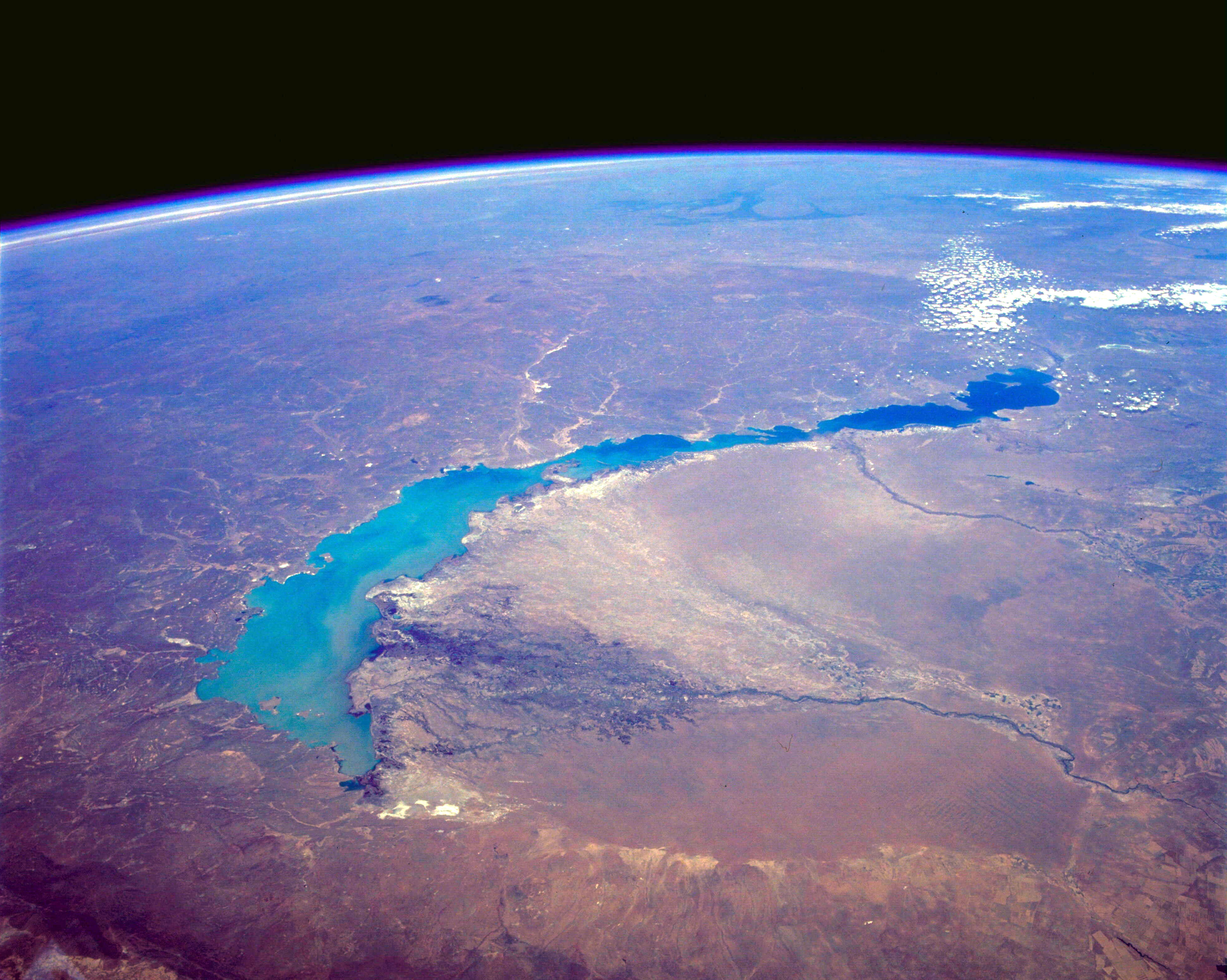
English: STS039-085-00E Lake Balkhash, Kazakhstan April 1991
The turquoise waters of Lake Balkhash can be seen in this northeast-looking, high-oblique photograph. The lake covers 6560 square miles (17 000 square kilometers), is nearly 350 miles (565 kilometers) long, but is only 45 miles (72 kilometers) at its maximum width. The average depth of Lake Balkhash is 20 feet (6 meters), but the lake reaches a maximum depth of 85 feet (26 meters) in its western half. Lake Balkhash extends from the Betpak Steppe in the west to the Kazakh Hills in the northeast. Visible in the photograph to the north of the lake is a vast undulating plain, and south-southeast of the lake are the Ili River and its delta. The Ili River separates two deserts. The larger, sandy Sary-Ishikotrau Desert lies northeast of the Ili River. A much smaller river, the Karatal, traverses this desert and empties into the eastern portion of Lake Balkhash. The Taukum Desert (brownish color) can be seen southwest of the Ili River. A large sandbar or spit (center of the photograph) separates the eastern, shallower, more saline part of Lake Balkhash from the deeper, fresher water of the western portion of the lake. The Ili River is fed by melting snow and glaciers of the Tien Shan ranges in China south of the lake (not visible in the photograph). Lake Balkhash has no river outlet and, even with the influx of fresh water from the Ili River, is shrinking because of evaporation; however, its rate of shrinkage is much less than that of the Aral Sea, which juts into Kazakhstan much farther to the west. |
| Dato | |
| Fonto | http://eol.jsc.nasa.gov/sseop/EFS/photoinfo.pl?PHOTO=STS039-85-E |
| Aŭtoro | NASA |
Permesiloj:
| La ĉi-supra dosiero estas publika havaĵo, ĉar ĝi apartenas al NASA. La kopirajta regularo de NASA asertas, ke "ĉiuj dokumentoj de NASA estas publika havaĵo, se ne estas donata kontraŭa deklaro". | ||
 |
Atentu:
|
Originala alŝutada protokolo
Transigita de en.wikipedia al Commons de C messier per CommonsHelper.
The original description page was here. All following user names refer to en.wikipedia.
- 2012-05-29 09:52 Lukemcurley 3948×3153× (1846896 bytes) Cropped some of the black space from the top of the photo to focus on the lake.
- 2012-05-29 09:39 Lukemcurley 3960×4001× (1289732 bytes) Uploading a public-domain item using [[Wikipedia:File_Upload_Wizard|File Upload Wizard]]
Dosierhistorio
Alklaku iun daton kaj horon por vidi kiel la dosiero tiam aspektis.
| Dato/Horo | Bildeto | Grandecoj | Uzanto | Komento | |
|---|---|---|---|---|---|
| nun | 03:43, 18 feb. 2014 | | 3 948 × 3 153 (1,76 MB) | OgreBot | (BOT): Reverting to most recent version before archival |
| 03:43, 18 feb. 2014 |  | 3 960 × 4 001 (1,23 MB) | OgreBot | (BOT): Uploading old version of file from en.wikipedia; originally uploaded on 2012-05-29 09:39:58 by Lukemcurley | |
| 17:12, 16 feb. 2014 |  | 3 948 × 3 153 (1,76 MB) | File Upload Bot (Magnus Manske) | Transfered from en.wikipedia by User:C messier using CommonsHelper |
Dosiera uzado
La jena paĝo ligas al ĉi tiu dosiero:
Suma uzado de la dosiero
La jenaj aliaj vikioj utiligas ĉi tiun dosieron:
- Uzado en ar.wikipedia.org
- Uzado en ast.wikipedia.org
- Uzado en bn.wikipedia.org
- Uzado en br.wikipedia.org
- Uzado en ca.wikipedia.org
- Uzado en cy.wikipedia.org
- Uzado en el.wikipedia.org
- Uzado en en.wikipedia.org
- Uzado en en.wikiquote.org
- Uzado en es.wikipedia.org
- Uzado en eu.wikipedia.org
- Uzado en fi.wikipedia.org
- Uzado en fr.wikipedia.org
- Uzado en gl.wikipedia.org
- Uzado en he.wikipedia.org
- Uzado en id.wikipedia.org
- Uzado en ja.wikipedia.org
- Uzado en kk.wikipedia.org
- Uzado en kn.wikipedia.org
- Uzado en ko.wikipedia.org
- Uzado en lfn.wikipedia.org
- Uzado en mk.wikipedia.org
- Uzado en mr.wikipedia.org
- Uzado en mt.wikipedia.org
- Uzado en nn.wikipedia.org
- Uzado en oc.wikipedia.org
- Uzado en pa.wikipedia.org
- Uzado en pnb.wikipedia.org
- Uzado en simple.wikipedia.org
- Uzado en sl.wikipedia.org
- Uzado en sv.wikipedia.org
- Uzado en sw.wikipedia.org
- Uzado en tg.wikipedia.org
- Uzado en th.wikipedia.org
- Uzado en vi.wikipedia.org
- Uzado en www.wikidata.org
- Uzado en zh-yue.wikipedia.org
- Uzado en zh.wikipedia.org