
Dosiero:Thames Tunnel-route.png

Grandeco de ĉi antaŭvido: 325 × 599 rastrumeroj. Aliaj distingivoj: 130 × 240 rastrumeroj | 260 × 480 rastrumeroj | 416 × 768 rastrumeroj | 555 × 1 024 rastrumeroj | 2 168 × 3 998 rastrumeroj.
Bildo en pli alta difino ((2 168 × 3 998 rastrumeroj, grandeco de dosiero: 7,16 MB, MIME-tipo: image/png))
| Jen dosiero de la Wikimedia-Komunejo. La priskribo en ties priskriba paĝo estas montrata suben.
|
Resumo
| Priskribo |
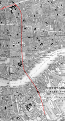
English: Map of the underground routing and approaches (highlighted in RED) to the Thames Tunnel, London UK, beginning at Whitechapel station and continuing south under Shadwell until reaching Wapping railway station, thence through the Thames Tunnel under the River Thames to Rotherhithe station and still underground passes beneath Southwark until it emerges from the ground near Deptford Road Station. |
| Dato | la 29-a de julio 2019 (alŝuta dato) |
| Fonto | La komuneja alŝutinto ricevis la dosieron de la aŭtoro aŭ de alia posedanto de aŭtoraj rajtoj per photosubmissions. |
| Aŭtoro | Route highlighting in RED by Jonathan Bluestone, derived from an Ordnance Survey map published ca. 1889 |
| Permeso (Reuzo de la dosiero) |
Permesiloj:
Derivative work:
| Ĉi tiu dosiero estas disponebla laŭ la Krea Komunaĵo CC0 1.0 Universala Publikaĵiga Dediĉo. | |
| La persono kiu asociis verkon kun ĉi tiu faro dediĉis la verkon kiel publikaĵon forlasante ĉiujn siajn rajtojn al la verko mondvaste sub aŭtorrajta leĝo inkluzivante ĉiujn rilatajn aŭ najbarajn rajtojn permesitajn de leĝo. Oni povas kopii, modifi, distribui kaj ludi la verkon, eĉ por komercaj kialoj, ĉiuj sen peto de permeso.
|
Map:
This work is an Ordnance Survey map over 50 years old, which is covered by Crown Copyright which in this case expires 50 years after publication. Ordnance Survey does however ask that they be credited and that the date of publication be given.
Any ancillary rights gained through the creation of the electronic version are granted as freely usable under any circumstances.
|
This work created by the United Kingdom Government is in the public domain.
This is because it is one of the following:
HMSO has declared that the expiry of Crown Copyrights applies worldwide (ref: HMSO Email Reply)
|
 |
Dosierhistorio
Alklaku iun daton kaj horon por vidi kiel la dosiero tiam aspektis.
| Dato/Horo | Bildeto | Grandecoj | Uzanto | Komento | |
|---|---|---|---|---|---|
| nun | 12:36, 29 jul. 2019 | | 2 168 × 3 998 (7,16 MB) | JGHowes | {{Information |Description={{en|1=Map of '''{{w|Thames Tunnel}}''', London UK. The underground portion is highlighted in <font color=red>'''''RED'''''</font color> beginning at {{w|Whitechapel station}} and continuing south under Shadwell until it reaches the Thames at {{w|Wapping railway station}}, where it goes under the Thames to {{w|Rotherhithe station}} and still underground passes beneath Southwark until it emerges from the ground close to Deptford Road Station.}} |Source={{author sourc... |
Dosiera uzado
La jena paĝo ligas al ĉi tiu dosiero:
Suma uzado de la dosiero
La jenaj aliaj vikioj utiligas ĉi tiun dosieron:
- Uzado en en.wikipedia.org
- Uzado en es.wikipedia.org
- Uzado en it.wikipedia.org