
Dosiero:Whitsunday Islands, Queensland, Australia.jpg

Grandeco de ĉi antaŭvido: 480 × 600 rastrumeroj. Aliaj distingivoj: 192 × 240 rastrumeroj | 384 × 480 rastrumeroj | 614 × 768 rastrumeroj | 819 × 1 024 rastrumeroj | 1 638 × 2 048 rastrumeroj | 4 000 × 5 000 rastrumeroj.
Bildo en pli alta difino ((4 000 × 5 000 rastrumeroj, grandeco de dosiero: 3,43 MB, MIME-tipo: image/jpeg))
| Jen dosiero de la Wikimedia-Komunejo. La priskribo en ties priskriba paĝo estas montrata suben.
|
Resumo
| Priskribo |
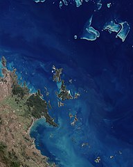
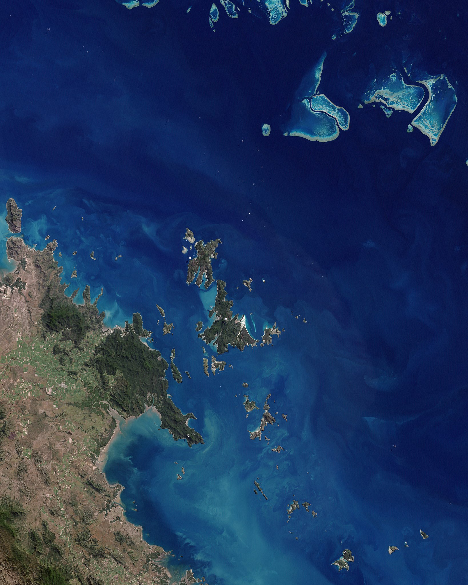
English: This scene is dominated by the largest island and namesake of the chain. Deep green forest covers most of Whitsunday Island, which is outlined by brilliant white sand beaches, the largest and most dramatic being Whitehaven Beach at the south-eastern end of the island. On Hamilton Island, the strong linear feature at the southern end shows where a jet-accessible runway was added to allow airlines from major Australian cities to fly directly to the islands. The swirls of pale blue around the islands show a mix of sandy bottom waters and shallow, fringing coral reefs. The green land in the south-western corner of the image is a small section of Conway Ranges National Park, on the shoreline of mainland Queensland.
Deutsch: Dieses photoähnliche Bild des Kerns der Whitsunday Islands wurde am 22. Mai 2003 mit dem Enhanced Thematic Mapper Plus (ETM+) des Landsat 7 erstellt. Das Bild wird von der größten Insel und Namensgeberin für die gesamte Inselgruppe dominiert. Den größtem Teil der Whitsunday Island bedecken tiefgrüne Wälder, die von brillanten weißen Sandstränden eingerahmt werden – der größte unter ihnen ist Whitehaven Beach im Südosten der Insel. |
| Dato | |
| Fonto | NASA Earth Observatory |
| Aŭtoro | Jesse Allen |
| Ceteraj versioj | File:Whitsunday Islands Landsat 7 with some captions.jpg |
Image acquired by the Enhanced Thematic Mapper Plus (ETM+) instrument on NASA’s Landsat 7 satellite. Landsat data provided by the United States Geological Survey.
Permesiloj:
| La ĉi-supra dosiero estas publika havaĵo, ĉar ĝi apartenas al NASA. La kopirajta regularo de NASA asertas, ke "ĉiuj dokumentoj de NASA estas publika havaĵo, se ne estas donata kontraŭa deklaro". | ||
 |
Atentu:
|
| Annotations | This image is annotated: View the annotations at Commons |
Dosierhistorio
Alklaku iun daton kaj horon por vidi kiel la dosiero tiam aspektis.
| Dato/Horo | Bildeto | Grandecoj | Uzanto | Komento | |
|---|---|---|---|---|---|
| nun | 12:26, 7 jan. 2010 | | 4 000 × 5 000 (3,43 MB) | Originalwana | {{Information |Description={{en|1=This scene is dominated by the largest island and namesake of the chain. Deep green forest covers most of Whitsunday Island, which is outlined by brilliant white sand beaches, the largest and most dramatic being Whitehave |
Dosiera uzado
La jena paĝo ligas al ĉi tiu dosiero:
Suma uzado de la dosiero
La jenaj aliaj vikioj utiligas ĉi tiun dosieron:
- Uzado en af.wikipedia.org
- Uzado en be.wikipedia.org
- Uzado en en.wikipedia.org
- Uzado en it.wikipedia.org
- Uzado en mr.wikipedia.org
- Uzado en nl.wikipedia.org
- Uzado en pl.wikipedia.org
- Uzado en ru.wikipedia.org
- Uzado en zh.wikipedia.org