
Dosiero:Earth-DSCOVR-20150706-IFV.jpg
Bildo en pli alta difino ((1 788 × 1 756 rastrumeroj, grandeco de dosiero: 646 KB, MIME-tipo: image/jpeg))
| Jen dosiero de la Wikimedia-Komunejo. La priskribo en ties priskriba paĝo estas montrata suben.
|
Resumo
| Priskribo |
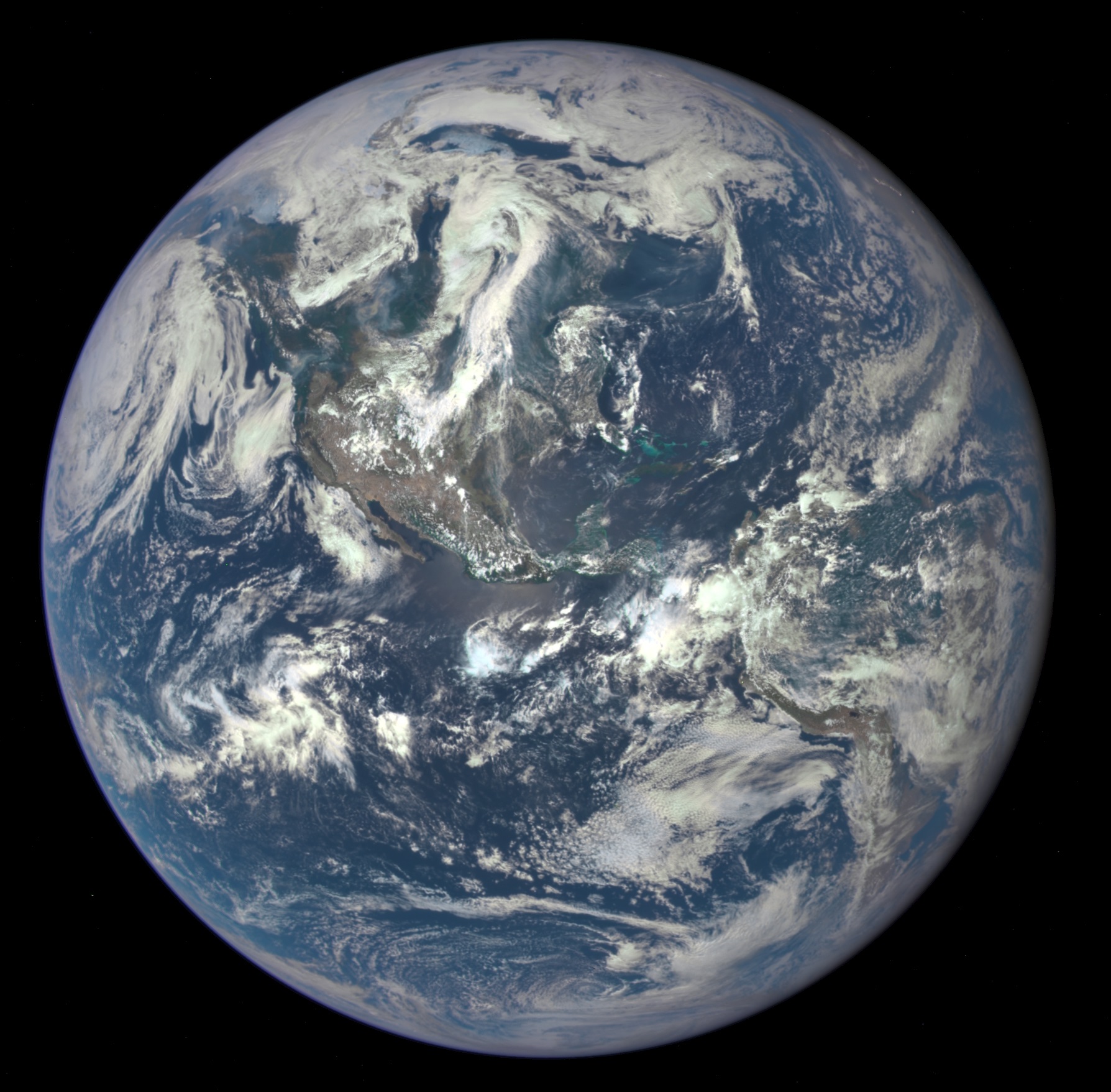
English: NASA Captures "EPIC" Earth Image
A NASA camera on the Deep Space Climate Observatory satellite has returned its first view of the entire sunlit side of Earth from nearly one million miles away. This color image of Earth was taken by NASA’s Earth Polychromatic Imaging Camera (EPIC), a four megapixel CCD camera and telescope. The image was generated by combining three separate images to create a photographic-quality image. The camera takes a series of 10 images using different narrowband filters -- from ultraviolet to near infrared -- to produce a variety of science products. The red, green and blue channel images are used in these color images. The image was taken July 6, 2015, showing North and Central America. The central turquoise areas are shallow seas around the Caribbean islands. This Earth image shows the effects of sunlight scattered by air molecules, giving the image a characteristic bluish tint. The EPIC team is working to remove this atmospheric effect from subsequent images. Once the instrument begins regular data acquisition, EPIC will provide a daily series of Earth images allowing for the first time study of daily variations over the entire globe. These images, available 12 to 36 hours after they are acquired, will be posted to a dedicated web page by September 2015. The primary objective of DSCOVR, a partnership between NASA, the National Oceanic and Atmospheric Administration (NOAA) and the U.S. Air Force, is to maintain the nation’s real-time solar wind monitoring capabilities, which are critical to the accuracy and lead time of space weather alerts and forecasts from NOAA. |
| Dato | Fotita je la 6-a de julio 2015, 19:01:11 |
| Fonto | http://www.nasa.gov/image-feature/nasa-captures-epic-earth-image (image link); see also https://epic.gsfc.nasa.gov/?date=2015-07-06 image #3. |
| Aŭtoro | NASA |
| Ceteraj versioj |
|


Permesiloj:
| La ĉi-supra dosiero estas publika havaĵo, ĉar ĝi apartenas al NASA. La kopirajta regularo de NASA asertas, ke "ĉiuj dokumentoj de NASA estas publika havaĵo, se ne estas donata kontraŭa deklaro". | ||
 |
Atentu:
|
Dosierhistorio
Alklaku iun daton kaj horon por vidi kiel la dosiero tiam aspektis.
| Dato/Horo | Bildeto | Grandecoj | Uzanto | Komento | |
|---|---|---|---|---|---|
| nun | 11:18, 21 jul. 2015 | | 1 788 × 1 756 (646 KB) | JorisvS | crop a bit |
| 16:01, 20 jul. 2015 |  | 2 048 × 2 048 (1,49 MB) | Drbogdan | User created page with UploadWizard |
Dosiera uzado
Neniu paĝo ligas al ĉi tiu dosiero.
Suma uzado de la dosiero
La jenaj aliaj vikioj utiligas ĉi tiun dosieron:
- Uzado en ca.wikipedia.org
- Uzado en en.wikipedia.org
- Uzado en en.wikiquote.org
- Uzado en en.wikiversity.org
- Uzado en es.wikipedia.org
- Uzado en fr.wikipedia.org
- Uzado en gl.wikipedia.org
- Uzado en he.wikipedia.org
- Uzado en incubator.wikimedia.org
- Uzado en it.wikipedia.org
- Uzado en ja.wikipedia.org
- Uzado en pl.wikipedia.org
- Uzado en ru.wikipedia.org
- Uzado en ru.wiktionary.org
- Uzado en tr.wikiquote.org
- Uzado en uk.wikipedia.org
- Uzado en www.wikidata.org
- Uzado en wuu.wikipedia.org