
Dosiero:Afsluitdijk Netherlands Satellite Photo by Sentinel-2 30 June 2018.jpg

Bildo en pli alta difino ((4 305 × 3 847 rastrumeroj, grandeco de dosiero: 12,89 MB, MIME-tipo: image/jpeg))
| Jen dosiero de la Wikimedia-Komunejo. La priskribo en ties priskriba paĝo estas montrata suben.
|
Resumo
| Priskribo |
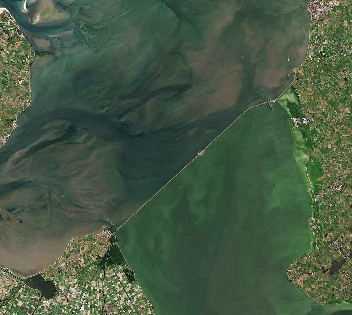
English: A satellite photo of the Afsluitdijk, The Netherlands, 30 June 2018. The Afsluitdijk changed the Zuiderzee into the IJsselmeer. To the north of the Afsluitdijk is the Wadden Sea, to the south is the IJsselmeer. Sensor: MSI on Sentinel-2A. Resolution: 10m. RGB Composites: True color, Band 4-3-2.
Nederlands: Een satellietfoto van de Afsluitdijk, Nederland, 30 juni 2018. De afsluitdijk veranderde de Zuiderzee in het IJsselmeer. Ten noorden van de Afsluitdijk is de Waddenzee, ten zuiden is het IJsselmeer. Sensor: MSI op Sentinel-2A. Resolutie: 10m. RGB-composieten: Ware Kleuren, Band 4-3-2. |
| Dato | |
| Fonto | |
| Aŭtoro | Copernicus Sentinel-2, ESA |
.jpg)
Permesiloj:
- Vi rajtas:
- kunhavigi – kopii, distribui kaj publikigi la verkon
- aliigi – modifi, adapti, kompletigi, transformi, uzi la tutan verkon aŭ ties partojn, memstare aŭ en aliaj verkoj
- La verko rajtas esti kunhavigata nur:
- atribuite – Vi devas atribui aŭtorecon, liveri ligilon al la permesilo kaj marki ĉu ŝanĝoj estis faritaj. Faru tion en aprobinda maniero, tamen ne sugestante, ke permesinto aprobas vin aŭ vian uzon.
- samkondiĉe – Se vi rekombinas la verkon, transformas ĝin aŭ kreas devenaĵon bazitan sur ĝi, vi rajtas distribui la rezultan verkon nur laŭ la sama aŭ kongrua permesilo kompare kun ĉi tiu.

|
This image contains data from a satellite in the Copernicus Programme, such as Sentinel-1, Sentinel-2 or Sentinel-3. Attribution is required when using this image.
Atribuite: Contains modified Copernicus Sentinel data 2018
The use of Copernicus Sentinel Data is regulated under EU law (Commission Delegated Regulation (EU) No 1159/2013 and Regulation (EU) No 377/2014). Relevant excerpts:
Free access shall be given to GMES dedicated data [...] made available through GMES dissemination platforms [...].
Access to GMES dedicated data [...] shall be given for the purpose of the following use in so far as it is lawful:
GMES dedicated data [...] may be used worldwide without limitations in time.
GMES dedicated data and GMES service information are provided to users without any express or implied warranty, including as regards quality and suitability for any purpose. |
Dosierhistorio
Alklaku iun daton kaj horon por vidi kiel la dosiero tiam aspektis.
| Dato/Horo | Bildeto | Grandecoj | Uzanto | Komento | |
|---|---|---|---|---|---|
| nun | 07:27, 4 jul. 2023 | | 4 305 × 3 847 (12,89 MB) | Artanisen | Uploaded a work by Copernicus Sentinel-2, ESA from Extracted from: North Holland with parts of Friesland and Flevoland by Sentinel-2 (Original 10m Res).jpg with UploadWizard |
Dosiera uzado
La jena paĝo ligas al ĉi tiu dosiero:
Suma uzado de la dosiero
La jenaj aliaj vikioj utiligas ĉi tiun dosieron:
- Uzado en af.wikipedia.org
- Uzado en arz.wikipedia.org
- Uzado en ast.wikipedia.org
- Uzado en ca.wikipedia.org
- Uzado en cs.wikipedia.org
- Uzado en de.wikipedia.org
- Uzado en en.wikipedia.org
- Uzado en es.wikipedia.org
- Uzado en fr.wikipedia.org
- Uzado en fy.wikipedia.org
- Uzado en hu.wikipedia.org
- Uzado en ja.wikipedia.org
- Uzado en ko.wikipedia.org
- Uzado en nds-nl.wikipedia.org
- Uzado en nds.wikipedia.org
- Uzado en nl.wikipedia.org
- Uzado en pl.wikipedia.org
- Uzado en pt.wikipedia.org
- Uzado en www.wikidata.org