
Dosiero:Amazon-river-NASA.jpg

Grandeco de ĉi antaŭvido: 600 × 600 rastrumeroj. Aliaj distingivoj: 240 × 240 rastrumeroj | 480 × 480 rastrumeroj | 768 × 768 rastrumeroj | 1 024 × 1 024 rastrumeroj | 2 048 × 2 048 rastrumeroj | 4 096 × 4 096 rastrumeroj.
Bildo en pli alta difino ((4 096 × 4 096 rastrumeroj, grandeco de dosiero: 2,79 MB, MIME-tipo: image/jpeg))
| Jen dosiero de la Wikimedia-Komunejo. La priskribo en ties priskriba paĝo estas montrata suben.
|
Resumo
| Priskribo |
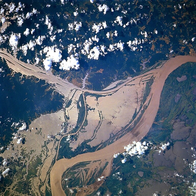
Afrikaans: STS078-751-094 Oorstroomde Amasonerivieroewers in westelike Pará-provinsie, Brasilië in Junie 1996. Die ligging is sowat halfpad tussen Manaus en die Amasonerivierdelta.
Hierdie beeld toon oorstroomde oewers van 'n klein segment van die Amasonerivier, insluitend die oerwouddorpies Oriximiná en Óbidos. Songlans op die modderige rivierwater fasiliteer die onderskeiding van land en water. Deur hierdie beeld met 'n gedetailleerde gebiedskaart te vergelyk, word dit duidelik dat die Amazonerivier sy oewers in die laagliggende dele aanliggend aan die vloedvlakte van die hoofkanaal oorstroom, en groot dele suid van die hoofkanaal staan ook onder (skoon) water. Ontbosde gebiede is binne die digbegroeide terrein aan die noordekant van die Amasonerivier waarneembaar. Die hoofkanaal van die Trombetasrivier kan suidooswaarts nagespeur word, van die linkerrand van die prent af, totdat die Trombetas tussen die oerwouddorpies Oriximiná en Óbidos met die Amasone saamvloei. English: A satellite image of a part of the Amazon River.
Esperanto: La bildo estas kopiita de wikipedia:en. La originala priskribo estas
English: Original caption: [altered to reflect rotation]
|
| Dato | |
| Fonto | http://earth.jsc.nasa.gov/sseop/EFS/photoinfo.pl?PHOTO=STS078-751-94 (file) |
| Aŭtoro | NASA |
| Pozicio de la objekto | | Tiu cxi bildo kaj pliaj sur OpenStreetMap |
|---|
This image or video was catalogued by one of the centers of the United States National Aeronautics and Space Administration (NASA) under Photo ID: STS078-751-94. This tag does not indicate the copyright status of the attached work. A normal copyright tag is still required. See Commons:Licensing. Other languages:
|
Permesiloj:
| La ĉi-supra dosiero estas publika havaĵo, ĉar ĝi apartenas al NASA. La kopirajta regularo de NASA asertas, ke "ĉiuj dokumentoj de NASA estas publika havaĵo, se ne estas donata kontraŭa deklaro". | ||
 |
Atentu:
|
Old file history
Transferred from English-Wikipedia:
| date/time | username | edit summary |
|---|---|---|
| 02:26, 6 January 2005 | en:User:Quadell | (tagged) |
| 18:08, 18 June 2004 | en:User:Sverdrup | (Image info) |
| 18:06, 18 June 2004 | en:User:Sverdrup | (A satellite image of a part of the <a href="/wiki/Amazon_River" title="Amazon River">Amazon River</a>) |
| Annotations | This image is annotated: View the annotations at Commons |
Dosierhistorio
Alklaku iun daton kaj horon por vidi kiel la dosiero tiam aspektis.
| Dato/Horo | Bildeto | Grandecoj | Uzanto | Komento | |
|---|---|---|---|---|---|
| nun | 17:13, 8 dec. 2022 | | 4 096 × 4 096 (2,79 MB) | JMK | boost saturation, add some contrast |
| 17:10, 8 dec. 2022 |  | 4 096 × 4 096 (2,69 MB) | JMK | rotate 180, north up | |
| 10:10, 10 nov. 2022 |  | 4 096 × 4 096 (15,22 MB) | Askeuhd | Higher resolution version | |
| 14:15, 10 okt. 2012 |  | 640 × 640 (418 KB) | Rotatebot | Bot: Image rotated by 180° | |
| 14:39, 29 jan. 2006 |  | 640 × 640 (377 KB) | Maksim | La bildo estas kopiita de wikipedia:en. La originala priskribo estas: A satellite image of a part of the Amazon River. {{PD-USGov-NASA}} '''Original caption:''' :''STS078-751-094 Amazon River, Western Para Province, Brazil June 1996'' :''This image s |
Dosiera uzado
La jena paĝo ligas al ĉi tiu dosiero:
Suma uzado de la dosiero
La jenaj aliaj vikioj utiligas ĉi tiun dosieron:
- Uzado en ar.wikipedia.org
- Uzado en ast.wikipedia.org
- Uzado en azb.wikipedia.org
- Uzado en ca.wikipedia.org
- Uzado en ce.wikipedia.org
- Uzado en cv.wikipedia.org
- Uzado en en.wikipedia.org
- Uzado en es.wikipedia.org
- Uzado en eu.wikipedia.org
- Uzado en fa.wikipedia.org
- Uzado en fr.wikipedia.org
- Uzado en fy.wikipedia.org
- Uzado en id.wikipedia.org
- Uzado en ilo.wikipedia.org
- Uzado en kk.wikipedia.org
- Uzado en krc.wikipedia.org
- Uzado en ml.wikipedia.org
- Uzado en mr.wikipedia.org
- Uzado en nl.wikipedia.org
- Uzado en no.wikipedia.org
- Uzado en os.wikipedia.org
- Uzado en pl.wiktionary.org
- Uzado en pt.wikipedia.org
- Uzado en rm.wikipedia.org
- Uzado en ru.wikipedia.org
- Uzado en uk.wikipedia.org
- Uzado en vec.wikipedia.org
- Uzado en vi.wikipedia.org
- Uzado en www.wikidata.org
- Uzado en zh-yue.wikipedia.org
- Uzado en zh.wikipedia.org