
Dosiero:Corinth, Greece (NASA).jpg

Bildo en pli alta difino ((2 514 × 1 686 rastrumeroj, grandeco de dosiero: 7,43 MB, MIME-tipo: image/jpeg))
| Jen dosiero de la Wikimedia-Komunejo. La priskribo en ties priskriba paĝo estas montrata suben.
|
.jpg)
Resumo
| Priskribo |
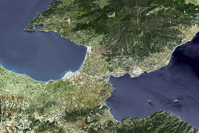
Español: Corinto y su istmo (Grecia). Foto satélite de la NASA.
English: The Isthmus of Corinth has played a very important role in the history of Greece. It is the only land bridge between the country's north (Attica) and south (Peloponnese). It is a 6 km wide tongue of land separating the Gulf of Corinth from the Saronic Sea. Populations, armies and commodities have got to move through it. In the 6th century BCE, the Greeks built the Diolkos, a 10 meter-wide stone roadway to pull ships across the Isthmus on wooden cylinders and wheeled vehicles. In 1882, a canal was started and completed 11 years later. It is 6343 meters long, 25 meters wide, and 8 meters deep.
With its 14 spectral bands from the visible to the thermal infrared wavelength region, and its high spatial resolution of 15 to 90 meters (about 50 to 300 feet), ASTER images Earth to map and monitor the changing surface of our planet. ASTER is one of five Earth-observing instruments launched December 18, 1999, on NASA's Terra satellite. The instrument was built by Japan's Ministry of Economy, Trade and Industry. A joint U.S./Japan science team is responsible for validation and calibration of the instrument and the data products. The broad spectral coverage and high spectral resolution of ASTER provides scientists in numerous disciplines with critical information for surface mapping, and monitoring of dynamic conditions and temporal change. Example applications are: monitoring glacial advances and retreats; monitoring potentially active volcanoes; identifying crop stress; determining cloud morphology and physical properties; wetlands evaluation; thermal pollution monitoring; coral reef degradation; surface temperature mapping of soils and geology; and measuring surface heat balance. The U.S. science team is located at NASA's Jet Propulsion Laboratory, Pasadena, Calif. The Terra mission is part of NASA's Science Mission Directorate.
|
| Dato | |
| Fonto | https://www.flickr.com/photos/pingnews/449549729/ (see also http://photojournal.jpl.nasa.gov/catalog/PIA01919) |
| Aŭtoro | NASA/GSFC/METI/ERSDAC/JAROS, and U.S./Japan ASTER Science Team |
| Ceteraj versioj | File:Corinth ast 2005129 lrg.jpg |
This image or video was catalogued by Johnson Space Center of the United States National Aeronautics and Space Administration (NASA) under Photo ID: PIA01919. This tag does not indicate the copyright status of the attached work. A normal copyright tag is still required. See Commons:Licensing. Other languages:
|
Permesiloj:
| La ĉi-supra dosiero estas publika havaĵo, ĉar ĝi apartenas al NASA. La kopirajta regularo de NASA asertas, ke "ĉiuj dokumentoj de NASA estas publika havaĵo, se ne estas donata kontraŭa deklaro". | ||
 |
Atentu:
|
Dosierhistorio
Alklaku iun daton kaj horon por vidi kiel la dosiero tiam aspektis.
| Dato/Horo | Bildeto | Grandecoj | Uzanto | Komento | |
|---|---|---|---|---|---|
| nun | 00:44, 12 aŭg. 2008 | | 2 514 × 1 686 (7,43 MB) | FlickreviewR | Replacing image by its original image from Flickr |
| 17:22, 10 jul. 2007 |  | 1 024 × 687 (629 KB) | Dorieo21 | {{Information |Description=Corinto y su istmo (Grecia). Foto sarélite de la NASA. |Source=http://www.flickr.com/photos/pingnews/449549729/ |Date=7 abril 2007 |Author=pingnews.com pingnews.com |Permission= |other_versions= }} |
Dosiera uzado
La jena paĝo ligas al ĉi tiu dosiero:
Suma uzado de la dosiero
La jenaj aliaj vikioj utiligas ĉi tiun dosieron:
- Uzado en arz.wikipedia.org
- Uzado en ceb.wikipedia.org
- Uzado en cs.wikipedia.org
- Uzado en es.wikipedia.org
- Uzado en fi.wikipedia.org
- Uzado en fr.wikipedia.org
- Uzado en hu.wikipedia.org
- Uzado en it.wikipedia.org
- Uzado en ja.wikipedia.org
- Uzado en ka.wikipedia.org
- Uzado en ko.wikipedia.org
- Uzado en pl.wikipedia.org
- Uzado en ro.wikipedia.org
- Uzado en ru.wikipedia.org
- Uzado en sv.wikipedia.org
- Uzado en sw.wikipedia.org
- Uzado en vls.wikipedia.org
- Uzado en www.wikidata.org
.jpg)