
Dosiero:DESERTEC-Map large.jpg

Bildo en pli alta difino ((5 776 × 4 184 rastrumeroj, grandeco de dosiero: 8,61 MB, MIME-tipo: image/jpeg))
| Jen dosiero de la Wikimedia-Komunejo. La priskribo en ties priskriba paĝo estas montrata suben.
|

|
Tiu ĉi bildo map respektive ĉiuj bildoj en tiu ĉi artikolo aŭ kategorio prefere estu rekreata(j) kiel vektora grafikaĵo en la formato SVG. Vektoraj formatoj por grafikaĵoj havas multajn avantaĝojn, detaloj troveblas anglalingve en la komuneja artikolo Commons:Media for cleanup. Se vi havas aŭ kreas SVG-version de tiu ĉi bildo, bonvolu alŝuti ĝin al la vikipedia komunejo. Post tiu ago, ĉi tiu ŝablono en la bildpaĝo estas anstataŭigenda per la ŝablono {{vector version available|nova dosiera nomo.svg}}.
|


| Priskribo |
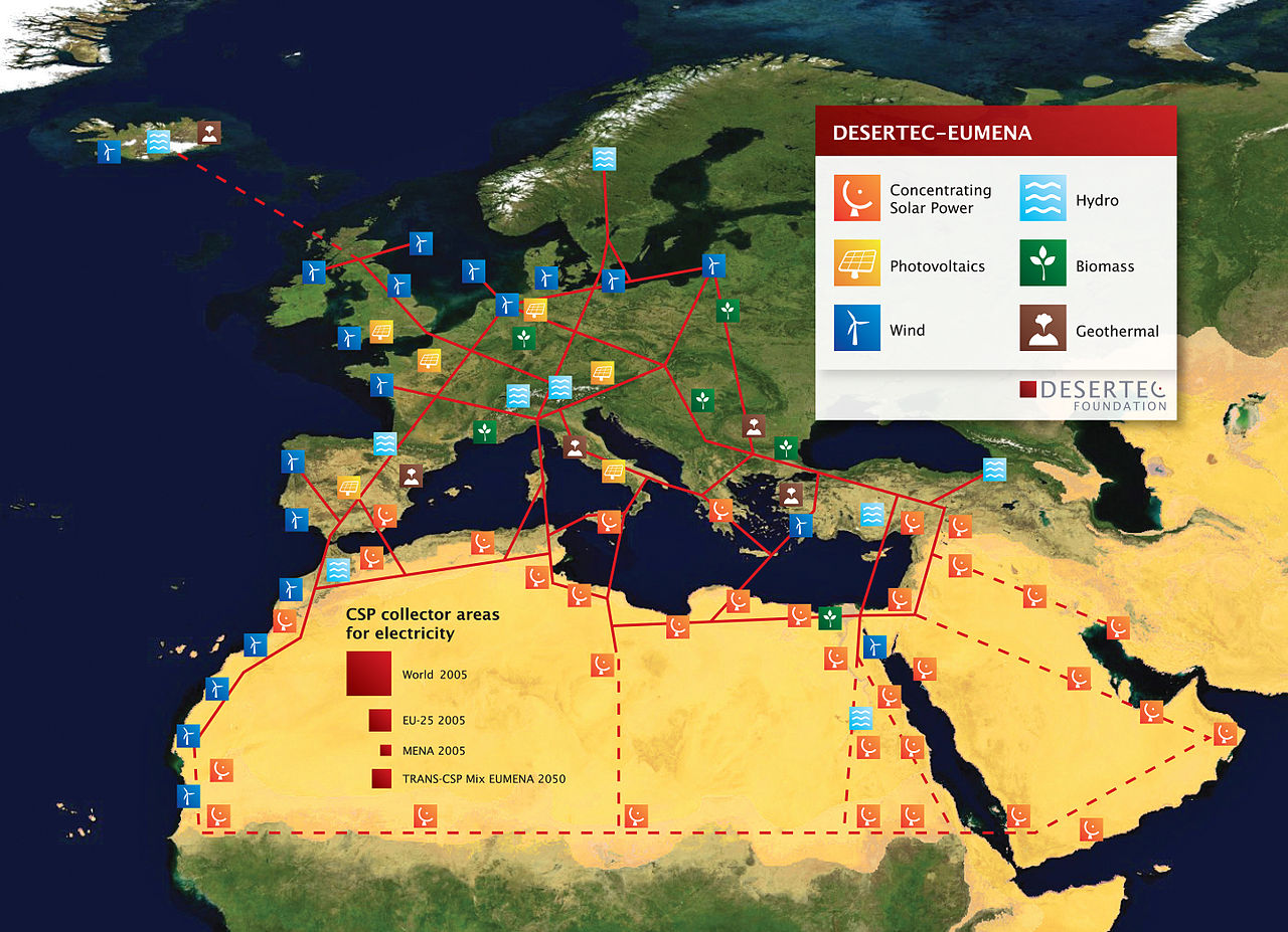
English: DESERTEC EU-MENA Map: Sketch of possible infrastructure for a sustainable supply of power to Europe, the Middle East and North Africa (EU-MENA) proposed by TREC)
For illustration: The red squares represent the total surfaces needed for solar collectors of Concentrating Solar Thermal Power (CSP) plants to provide the present electricity demands - for the world (18.000 TWh/a, 300x300 km) - for Europe (EU 3.200 TWh/a, 125x125 km) - and for Germany or MENA (Middle East and North Africa, about 600 TWh/a, 55x55 km). - The square labeled "TRANS-CSP Mix EUMENA 2050" indicates the surface needed for solar collectors to realize DESERTEC in EU-MENA (according to the TRANS-CSP scenario by DLR). This way the needs for seawater desalination and about two-thirds of the rising electricity consumption in the MENA region could be provided and about 17 percent of the European electricity consumption in 2050 (2,940 TWh/a, 120x120 km² in total). In reality numerous CSP-Plants will be spread in the deserts of EU-MENA and around the globe.
Deutsch: DESERTEC EU-MENA Karte: Skizze einer möglichen Infrastruktur für eine nachhaltige Stromversorgung in Europa, dem Nahen Osten und Nord-Afrika (EU-MENA).
Zur Veranschaulichung: Die durch die roten Quadrate markierten Flächen für Solarkollektoren würden genügen, um in solarthermischen Kraftwerken (CSP) den Strombedarf - der Welt (18.000 TWh/a, 300x300 km), - Europas (EU, 3.200 TWh/a, 125x125 km) - und von Deutschland bzw. MENA (Middle East and North Africa, ca. 600 TWh/a, 55x55 km) zu erzeugen. - Das Quadrat "TRANS-CSP Mix EUMENA 2050" zeigt die insgesamt benötigte Fläche für Solarkollektoren, um DESERTEC in EU-MENA zu realisieren (entsprechend dem TRANS-CSP Szenario des DLR). Auf diese Weise könnte genügend Energie erzeugt werden, um den Bedarf an Meerwasserentsalzung und zwei Drittel des bis 2050 stark wachsenden Strombedarfs der MENA-Region zu decken sowie etwa 17 Prozent des europäischen Strombedarfs (zusammen 2,940 TWh/a, 120x120 km). In der Realität werden viele CSP-Kraftwerke über die Wüsten der MENA-Region und der Welt verteilt sein. Die gestrichelten Linien stellen eine zweite Ausbaustufe dar. |
| Dato | |
| Fonto | http://www.desertec.org/fileadmin/downloads/press/DESERTEC-Map.zip |
| Aŭtoro | DESERTEC Foundation, www.desertec.org |
| Permeso (Reuzo de la dosiero) |
Ĉi tiu dosiero estas disponebla laŭ la permesilo Krea Komunaĵo Atribuite-Samkondiĉe 2.5 Ĝenerala.
|
| Ceteraj versioj |
|

Dosierhistorio
Alklaku iun daton kaj horon por vidi kiel la dosiero tiam aspektis.
| Dato/Horo | Bildeto | Grandecoj | Uzanto | Komento | |
|---|---|---|---|---|---|
| nun | 19:40, 7 feb. 2011 | | 5 776 × 4 184 (8,61 MB) | Benderson2~commonswiki | Udated version http://www.desertec.org/en/press/ without symols in the Western Sahara conflict region. |
| 17:39, 5 mar. 2009 |  | 5 777 × 4 185 (8,09 MB) | Chstdu | {{Information |Description={{en|1=Sketch of possible infrastructure for a sustainable supply of power to EUrope, the Middle East and North Africa (EU-MENA) (Euro-Supergrid with a EU-MENA-Connection proposed by [[w:Trans-Mediterranean_Renewable_Energy_Coop |
Dosiera uzado
La jena paĝo ligas al ĉi tiu dosiero:
Suma uzado de la dosiero
La jenaj aliaj vikioj utiligas ĉi tiun dosieron:
- Uzado en ar.wikipedia.org
- Uzado en ca.wikipedia.org
- Uzado en ckb.wikipedia.org
- Uzado en cs.wikipedia.org
- Uzado en de.wikipedia.org
- Sonnenenergie
- Europäisches Verbundsystem
- Erneuerbare Energien
- Desertec
- Energiewende
- Diskussion:Desertec/Archiv/1
- Wikipedia Diskussion:Hauptseite/Artikel des Tages/Archiv/Vorschläge/2011/1
- Wikipedia Diskussion:Hauptseite/Artikel des Tages/Archiv/Vorschläge/2012/2
- Wikipedia:Hauptseite/Archiv/10. November 2012
- Uzado en en.wikipedia.org
- Uzado en es.wikipedia.org
- Uzado en fi.wikipedia.org
- Uzado en fr.wikipedia.org
- Uzado en fr.wikiversity.org
- Uzado en hr.wikipedia.org
- Uzado en hu.wikipedia.org
- Uzado en it.wikipedia.org
- Uzado en ja.wikipedia.org
- Uzado en pt.wikipedia.org
- Uzado en ru.wikipedia.org
- Uzado en shi.wikipedia.org
- Uzado en sh.wikipedia.org
- Uzado en sv.wikipedia.org
- Uzado en uk.wikipedia.org
- Uzado en vi.wikipedia.org
- Uzado en www.wikidata.org
- Uzado en zh.wikipedia.org