
Dosiero:Metro de Paris - Plan traversee sous-fluviale ligne A Nord-Sud.jpg
Grandeco de ĉi antaŭvido: 800 × 533 rastrumeroj. Aliaj distingivoj: 320 × 213 rastrumeroj | 640 × 426 rastrumeroj | 1 024 × 682 rastrumeroj | 1 280 × 853 rastrumeroj | 2 702 × 1 800 rastrumeroj.
Bildo en pli alta difino ((2 702 × 1 800 rastrumeroj, grandeco de dosiero: 1,29 MB, MIME-tipo: image/jpeg))
| Jen dosiero de la Wikimedia-Komunejo. La priskribo en ties priskriba paĝo estas montrata suben.
|
Resumo
| Priskribo |
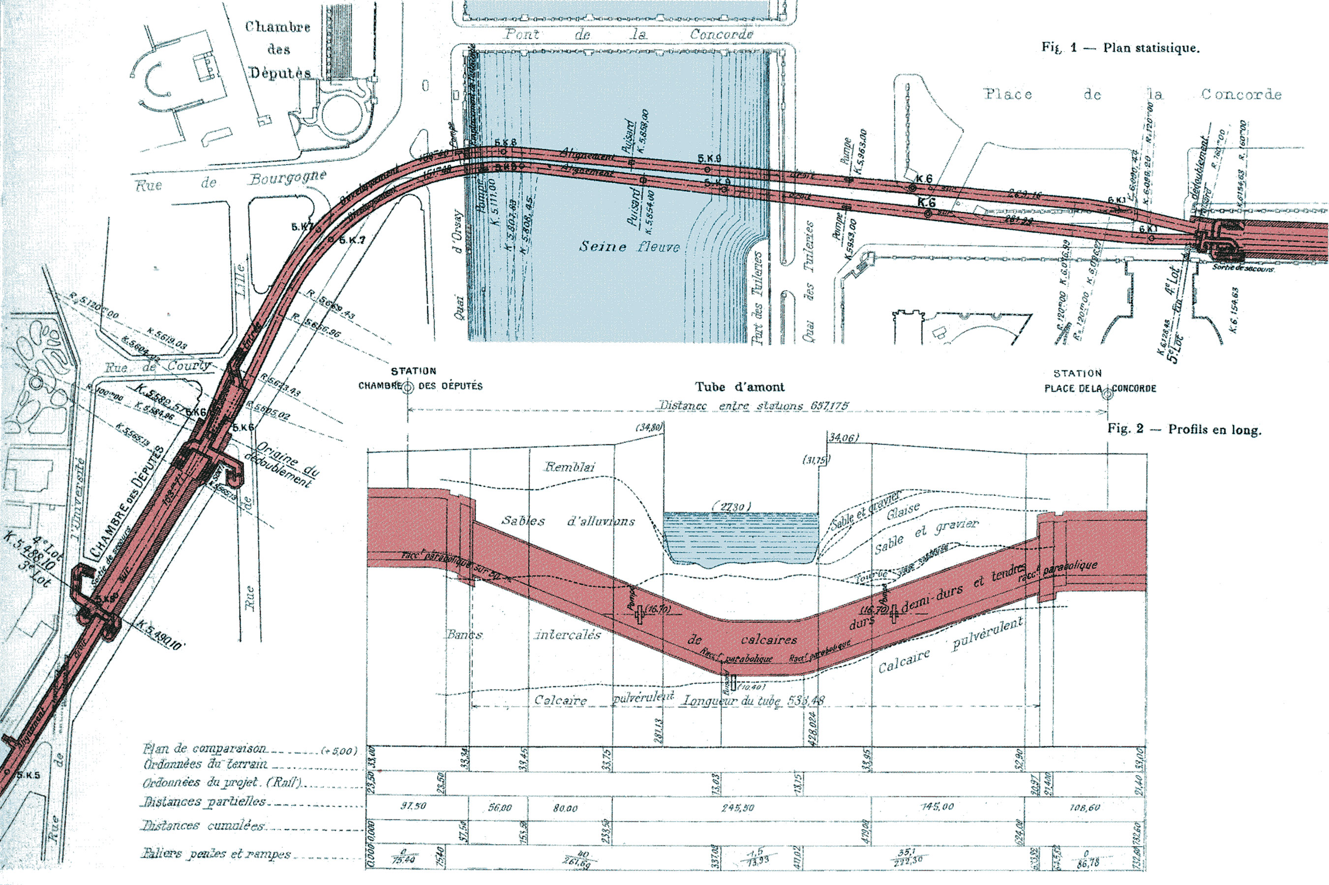
Français : Ligne A du Nord-Sud (actuelle ligne 12 du métro de Paris), France. Profil en long et en plan de la traversée sous-fluviale. |
| Dato | |
| Fonto | Double passage tubulaire sous la seine exécuté de 1906 a 1909 pour la traversée du chemin de fer Nord-Sud de Paris - Planche 1 - Annales des ponts et chaussées. 1ère partie. Mémoires et documents relatifs à l'art des constructions et au service de l'ingénieur, 1913 tome I |
| Aŭtoro | Georges Bechmann (1848-1927) |
Permesiloj:
This work is in the public domain in the United States because it was published (or registered with the U.S. Copyright Office) before January 1, 1929.
Public domain works must be out of copyright in both the United States and in the source country of the work in order to be hosted on the Commons. If the work is not a U.S. work, the file must have an additional copyright tag indicating the copyright status in the source country.
Note: This tag should not be used for sound recordings. |
This file is in the public domain because Identified as public domain on the French National Library website
|
Link to the article: [1]
Dosierhistorio
Alklaku iun daton kaj horon por vidi kiel la dosiero tiam aspektis.
| Dato/Horo | Bildeto | Grandecoj | Uzanto | Komento | |
|---|---|---|---|---|---|
| nun | 01:04, 18 okt. 2008 | | 2 702 × 1 800 (1,29 MB) | Clicsouris | == Description == {{Information |Description={{Fr|Ligne A du Nord-Sud (actuelle ligne 12 du métro de Paris), France. Profil en long et en plan de la traversée sous-fluviale.}} |Source=Scan personnel (own work) |Date=ca 1910 |Author=Inconnu (unknown) |Pe |
Dosiera uzado
La jena paĝo ligas al ĉi tiu dosiero:
Suma uzado de la dosiero
La jenaj aliaj vikioj utiligas ĉi tiun dosieron:
- Uzado en fr.wikipedia.org
- Uzado en ja.wikipedia.org
- Uzado en nl.wikipedia.org
- Uzado en pl.wikipedia.org