
Dosiero:Auckland20061016222837.jpg

Grandeco de ĉi antaŭvido: 674 × 600 rastrumeroj. Aliaj distingivoj: 270 × 240 rastrumeroj | 539 × 480 rastrumeroj | 863 × 768 rastrumeroj | 1 151 × 1 024 rastrumeroj | 2 301 × 2 048 rastrumeroj | 5 599 × 4 983 rastrumeroj.
Bildo en pli alta difino ((5 599 × 4 983 rastrumeroj, grandeco de dosiero: 10,15 MB, MIME-tipo: image/jpeg))
| Jen dosiero de la Wikimedia-Komunejo. La priskribo en ties priskriba paĝo estas montrata suben.
|
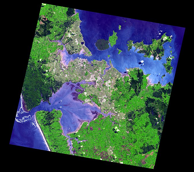
Resumo
Satellite image of Auckland, New Zealand, and the islands of the inner Hauraki Gulf.
Data Acquired: 2006-10-16
Corner points:
- Image width = 5599 height = 4983 bands = 3
Geo Projection
- Top Left -36.611691 174.364053
- Lat Increment 0.0001350000 Long Increment 0.0001689228
Full Image:-
- UL = -36.611691 174.364053 UR = -36.611691 175.309683
- LL = -37.284261 174.364053 LR = -37.284261 175.309683
Actual Image:-
- Image_UL = -36.623571 174.567099 Image_UR = -36.720366 175.267959
- Image_LL = -37.175316 174.409325 Image_LR = -37.272651 175.115253
- Image_UL_Loc = 1202 88 Image_UR_Loc = 5351 805
- Image_LL_Loc = 268 4175 Image_LR_Loc = 4447 4896
Source: http://ava.jpl.nasa.gov/public/2006/10/16/20061016222837-1200x1200.jpg[dead link], listed on this page archive copy at the Wayback Machine in the ASTER Volcano Archive.
Larger version stored in this image's history was downloaded from http://ava.jpl.nasa.gov/public/2006/10/16/20061016222837.jpg[dead link].
.jpg)
.jpg)
.jpg)
.jpg)
.jpg)
.jpg)
Permesiloj:
| La ĉi-supra dosiero estas publika havaĵo, ĉar ĝi apartenas al NASA. La kopirajta regularo de NASA asertas, ke "ĉiuj dokumentoj de NASA estas publika havaĵo, se ne estas donata kontraŭa deklaro". | ||
 |
Atentu:
|
Dosierhistorio
Alklaku iun daton kaj horon por vidi kiel la dosiero tiam aspektis.
| Dato/Horo | Bildeto | Grandecoj | Uzanto | Komento | |
|---|---|---|---|---|---|
| nun | 00:48, 24 sep. 2013 | | 5 599 × 4 983 (10,15 MB) | Avenue | Higher resolution |
| 09:25, 8 sep. 2007 |  | 1 200 × 1 068 (224 KB) | Avenue | Satellite image of Auckland, New Zealand, and the islands of the inner Hauraki Gulf. Data Acquired: 2006-10-16 Corner points: * Image width = 5599 height = 4983 bands = 3 Geo Projection * Top Left -36.611691 174.364053 * Lat Increment 0.0001350000 L | |
| 09:18, 8 sep. 2007 |  | 5 599 × 4 983 (5,44 MB) | Avenue | Satellite image of Auckland, New Zealand, and the islands of the inner Hauraki Gulf. Data Acquired: 2006-10-16 Corner points: Image width = 5599 height = 4983 bands = 3 Geo Projection Top Left -36.611691 174.364053 Lat Increment 0.0001350000 Long |
Dosiera uzado
Neniu paĝo ligas al ĉi tiu dosiero.
Suma uzado de la dosiero
La jenaj aliaj vikioj utiligas ĉi tiun dosieron:
- Uzado en gu.wikipedia.org
- Uzado en kn.wikipedia.org
- Uzado en nn.wikipedia.org