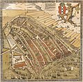
Dosiero:De Groote Kaart van Amsterdam in 1544 (The Big Map of Amsterdam in 1544) by Cornelis Anthonisz.jpg

Paĝenhavo ne ekzistas en aliaj lingvoj.
El Vikipedio, la libera enciklopedio

Bildo en pli alta difino((8 738 × 8 595 rastrumeroj, grandeco de dosiero: 20,92 MB, MIME-tipo: image/jpeg))

Jen dosiero de la Wikimedia-Komunejo. La priskribo en ties priskriba paĝo estas montrata suben.
La Komunejo estas dosieruja retejo de libere licencitaj dosieroj.

Resumo

Artisto/Kreinto
Cornelis Anthonisz.  (ĉirkaŭ 1505
date QS:P,+1505–00–00T00:00:00Z/9,P1480,Q5727902
–1553)  wikidata:Q2761474
 
Cornelis Anthonisz.
Alternativaj nomoj
Cornelis Anthoniszoon, Cornelis Anthonisz. Teunissen, Cornelis Anthonisz. Teunisz., Cornelis Anthonisz. Theunissen, Cornelis Anthonisz. Thonisz.
Priskribo nederlanda pentristo, kartografiisto, gravuristo kaj desegnisto
Dato de naskiĝo/morto ĉirkaŭ 1505
date QS:P,+1505-00-00T00:00:00Z/9,P1480,Q5727902
1553 Edit this at Wikidata
Loko de naskiĝo/morto Amsterdamo Amsterdamo
Loko de laboro
Norma datumaro
artist QS:P170,Q2761474
Titolo
Nederlands: De Groote kaart van Amsterdam in 1544 van Kornelis Antoniszoon... behoorende bij het vijfde deel der geschiedenis van Amsterdam / door J. Ter Gouw, naar het oorspronkelijke gephotographeerd...
English: The Big Map of Amsterdam in 1544 by Kornelis Antoniszoon... belonging to the fifth part of the history of Amsterdam / by J. Ter Gouw, photographed after the original...
Priskribo
Français : Sujet : Amsterdam. Couverture : Pays-Bas. Langue : néerlandais. Éditeur : T. Van Holkema (Amsterdam).
English: Subject: Amsterdam. Coverage: Netherlands. Language: Dutch. Publisher: T. Van Holkema (Amsterdam). This is the full map. Extra info: "A bird's eye view of Amsterdam looking south. This is the city before the construction of the semi-circular ring of canals. It is bordered by the IJ, the Singel in the west, and the Kloveniersburgwal/Gelderse Kade in the east. The waterway in the middle (connecting the Dam with the IJ) is known as the Damrak. Ships were unloaded on the west bank of the Damrak, indicated on the map as ‘Opt Waeter’ (on the water). Woodcut by Cornelis Anthonisz. dated 1544. This version is a reprint published around 1885."
Dato 1885 (the original version is from 1544)
Dimensioj alto: 30 cm; larĝo: 36 cm
dimensions QS:P2048,30U174728
dimensions QS:P2049,36U174728
institution QS:P195,Q193563
Surskribaĵoj

Caption :

De vermaerde koopstadt / van Amstelredam, gheconterfeyt met alle / sijn Wateren, Bruggen, Straten, kercken, kloo- / steren, Huysen, Toorens, Poorten ende Mueren, / ende omleggende situatie, gemaekt ter eeren K. M. / ende oock den Eersamen Raedt der selver Stadt, / ende alle Liefhebberen der Konste, etc. // Wtgegeven by Cornelis Anthonizoon Schil- / der, met Octroye der K. M. onsen ghenadighsten Heere van 't selfde niet te / moghen nae-drucken noch verkoopen binnen den tijdt van ses Jaren lanck / gheduerende, ende ghedateert van den Jare duysent vijf-honderd drie-en- / veertigh, op seeckere penen int selvde Octroye begrepen, op dat hem een yege- / lijck voor schade verhoede mach. // Dese afbeeldinghe vindtmen te koop in die ver- / maerde koopstadt van Amstelredam achter de Nieuwe Kerck / by den voorsz Cornelis Anthoniszoon, Schilder / inde Schrijvende handt.
Referenco
Français : Notice du catalogue : http://catalogue.bnf.fr/ark:/12148/cb40719984d
Fonto/Fotisto
Français : Bibliothèque nationale de France, département Cartes et plans, GE DD-2763
Bibliothèque nationale de France
(25/28)
English: Bibliothèque nationale de France, Maps and plans department, GE DD-2763
Permeso
(Reuzo de la dosiero)
Previous public domain rationale, no longer applicable
Public domain
This image from the Bibliothèque nationale de France (BnF) is a reproduction by scanning of a bidimensional work that is now in the public domain ({{PD-scan}}). For this reason, it is in the public domain.
This image can also be seen on Gallica: Image btv1b525134777.

العربية  Deutsch  English  español  français  galego  italiano  日本語  македонски  Nederlands  português  русский  sicilianu  slovenščina  українська  +/−

Permesiloj:

Ĉi tio estas fidela fotografia reproduktaĵo de originala dudimensia artverko. La artverko mem estas publika havaĵo pro jena kialo:
Public domain

Tiu ĉi verko estas publika havaĵo en tiuj landoj, kies kopirajtado validas por longo de vivo plus 100 jaroj aŭ malpli.


This work is in the public domain in the United States because it was published (or registered with the U.S. Copyright Office) before January 1, 1929.

La oficiala sinteno de la Vikimedia Fondaĵo estas ke "fidelaj reproduktaĵoj de dudimensiaj publikhavaĵaj artverkoj estas publika havaĵo, kaj malaj asertoj prezentas atakon al la esenco de la publikhavaĵa koncepto". Vidu detalojn ĉe Commons:When to use the PD-Art tag.
Tiu ĉi fotografia reproduktaĵo estas sekve ankaŭ konsiderata publika havaĵo. Bonvolu atenti ke, depende de lokaj leĝoj, reuzo de tiu ĉi enhavo povas esti malpermesita aŭ limigita en via jurisdikcio. Vidu Commons:Reuse of PD-Art photographs.

Titoloj

Donu unulinian priskribon de la enhavo de ĉi tiu dosiero

Eroj prezentitaj en ĉi tiu dosiero

montras

image/jpeg

Dosierhistorio

Alklaku iun daton kaj horon por vidi kiel la dosiero tiam aspektis.

Dato/HoroBildetoGrandecojUzantoKomento
nun02:46, 9 apr. 2023Bildeto por versio ekde 02:46, 9 apr. 20238 738 × 8 595 (20,92 MB)ArtanisenImproved alignment of the sections, reduced grid lines (same source)
19:34, 7 apr. 2023Bildeto por versio ekde 19:34, 7 apr. 20238 857 × 8 787 (22,31 MB)ArtanisenImproved spacing of the artwork sections (same source)
07:00, 7 apr. 2023Bildeto por versio ekde 07:00, 7 apr. 20238 955 × 8 857 (22,76 MB)ArtanisenUploaded a work by Cornelis Anthonisz. (circa 1505-1553). Auteur du texte from Bibliothèque nationale de France, département Cartes et plans, GE DD-2763 Bibliothèque nationale de France (25/28) - http://gallica.bnf.fr/ark:/12148/btv1b525134777/ with UploadWizard

La jena paĝo ligas al ĉi tiu dosiero:

Suma uzado de la dosiero

La jenaj aliaj vikioj utiligas ĉi tiun dosieron:

Vidi plian ĝeneralan uzadon de ĉi tiu dosiero.

Metadatumoj