
Dosiero:DunkerChurchAntietam1862.jpg
Grandeco de ĉi antaŭvido: 750 × 600 rastrumeroj. Aliaj distingivoj: 300 × 240 rastrumeroj | 600 × 480 rastrumeroj | 960 × 768 rastrumeroj | 1 280 × 1 024 rastrumeroj | 2 560 × 2 048 rastrumeroj | 3 000 × 2 400 rastrumeroj.
Bildo en pli alta difino ((3 000 × 2 400 rastrumeroj, grandeco de dosiero: 2,54 MB, MIME-tipo: image/jpeg))
| Jen dosiero de la Wikimedia-Komunejo. La priskribo en ties priskriba paĝo estas montrata suben.
|
Resumo
| Priskribo |
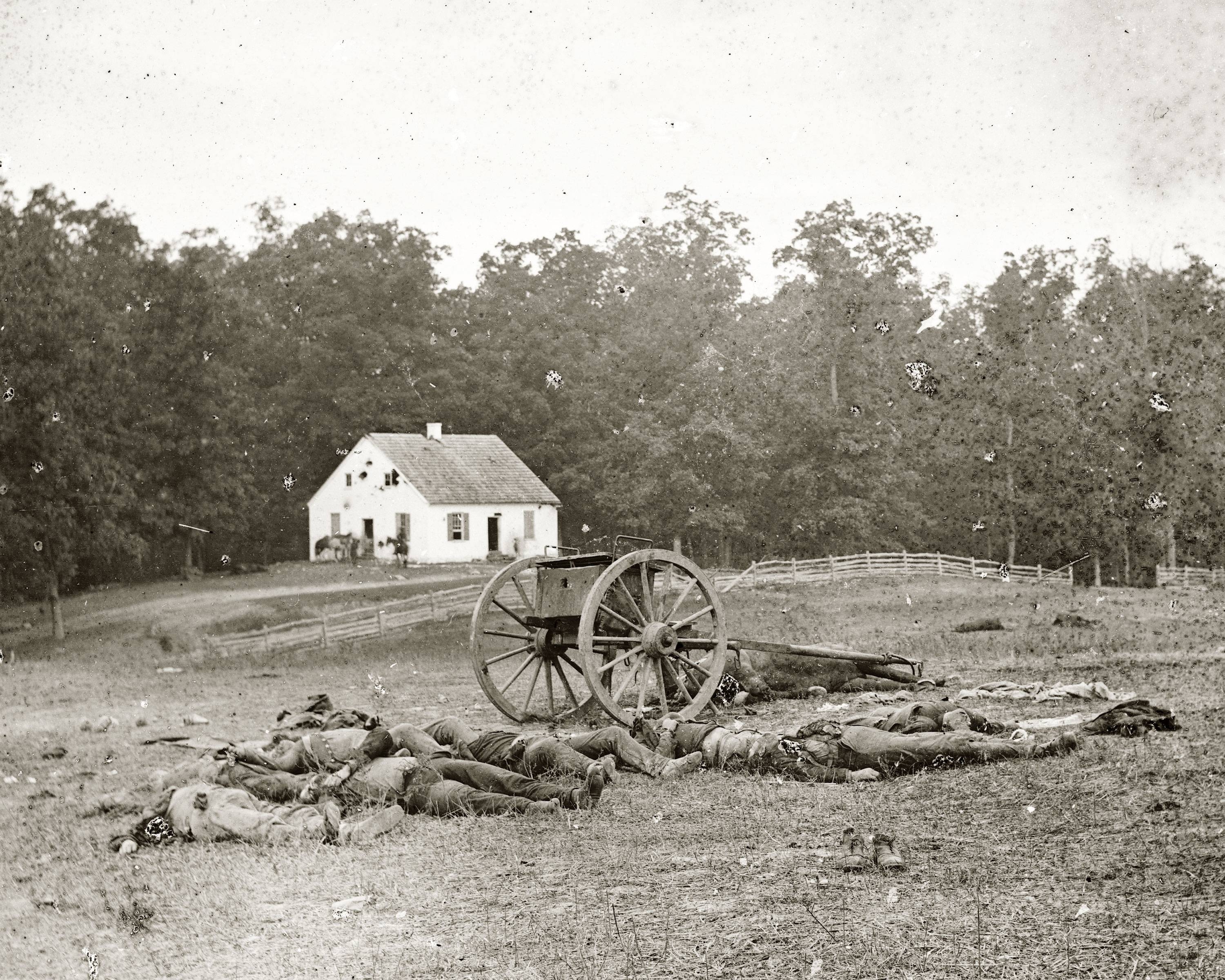
English: The Dunker Church to the north of Sharpsburg, Maryland marks where one of the bloodiest battles in American history would begin at dawn on September 17, 1862. Here, Confederate dead lay on the field. |
||||||||||||||||||||||||||
| Dato | |||||||||||||||||||||||||||
| Fonto | National Park Service (United States) | ||||||||||||||||||||||||||
| Aŭtoro |
|
||||||||||||||||||||||||||

| Pozicio de la fotilo | | Tiu cxi bildo kaj pliaj sur OpenStreetMap |
|---|
Permesiloj:
This media file is in the public domain in the United States. This applies to U.S. works where the copyright has expired, often because its first publication occurred prior to January 1, 1929, and if not then due to lack of notice or renewal. See this page for further explanation.
|
 | |
 |
This image might not be in the public domain outside of the United States; this especially applies in the countries and areas that do not apply the rule of the shorter term for US works, such as Canada, Mainland China (not Hong Kong or Macao), Germany, Mexico, and Switzerland. The creator and year of publication are essential information and must be provided. See Wikipedia:Public domain and Wikipedia:Copyrights for more details.
|
Dosierhistorio
Alklaku iun daton kaj horon por vidi kiel la dosiero tiam aspektis.
| Dato/Horo | Bildeto | Grandecoj | Uzanto | Komento | |
|---|---|---|---|---|---|
| nun | 22:45, 16 jul. 2022 | | 3 000 × 2 400 (2,54 MB) | Adam Cuerden | c:User:Rillke/bigChunkedUpload.js: |
| 20:23, 26 okt. 2017 |  | 1 174 × 752 (465 KB) | Magnolia677 | Higher resolution. | |
| 22:45, 13 maj. 2011 |  | 487 × 396 (138 KB) | Cropbot | upload cropped version, operated by User:Beao. Summary: cropped | |
| 17:23, 18 jul. 2009 |  | 500 × 408 (143 KB) | Berean Hunter | {{Information |Description={{en|1=The Dunker Church to the north of Sharpsburg, Maryland marks where one of the bloodiest battles in American history would begin at dawn on September 17, 1862. here, both Union and Confederate lay together on the field.}} |
Dosiera uzado
La jena paĝo ligas al ĉi tiu dosiero:
Suma uzado de la dosiero
La jenaj aliaj vikioj utiligas ĉi tiun dosieron:
- Uzado en azb.wikipedia.org
- Uzado en en.wikipedia.org
- Uzado en en.wikiquote.org
- Uzado en fa.wikipedia.org
- Uzado en fr.wikipedia.org
- Uzado en he.wikipedia.org
- Uzado en la.wikipedia.org
- Uzado en ms.wikipedia.org
- Uzado en nl.wikipedia.org
- Uzado en oc.wikipedia.org
- Uzado en pt.wikipedia.org
- Uzado en ro.wikipedia.org
- Uzado en zh.wikipedia.org