
Dosiero:Empire akkad.svg

Bildo en pli alta difino (SVG-dosiero, 1 475 × 1 149 rastrumeroj, grandeco de dosiero: 2,34 MB)
| Jen dosiero de la Wikimedia-Komunejo. La priskribo en ties priskriba paĝo estas montrata suben.
|
Resumo

|
Ĉi tiu SVG-dosiero enhavas enkonstruitan tekston, kiu estas tradukebla en vian lingvon uzante ilon por traduki SVG-dosierojn aŭ ajnan kapablan SVG-redaktilon. Por pliaj informoj vidu: Pri tradukado de SVG-dosieroj. |
| Priskribo |
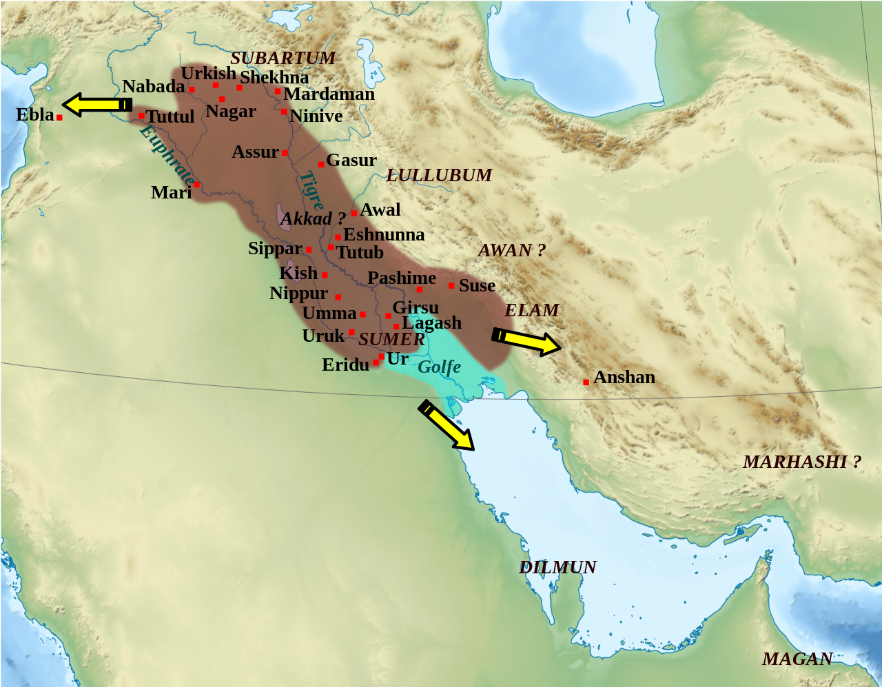
English: Mapa que mostra l'extensió aproximada de l'imperi Accadi durant el regnat de Narâm-Sîn (2254-2218 a.C. en la cronologia breu). Français : Carte de l'extension approximative de l'empire d'Akkad sous le règne de Narâm-Sîn (2254-2218 av. J.-C. selon la chronologie moyenne), et des directions des campagnes militaires extérieures. Sources : B. Lafont et M. Sauvage dans M. Sauvage (dir.), Atlas historique du Proche-Orient ancien, Paris, Les Belles Lettres, 2020, p. 70 ; P. Michalowski, « The Kingdom of Akkad in Contact with the World », dans The Oxford History of the Ancient Near East, Volume 1: From the Beginnings to Old Kingdom Egypt and the Dynasty of Akkad, New York, Oxford University Press, 2020, p. 688 fig. 10.1. |
| Dato | (UTC) |
| Fonto | |
| Aŭtoro |
|
| Ceteraj versioj |
File:Empire akkad.svg has 2 translations.
Other related versions: []
|


| Pozicio de la fotilo | | Tiu cxi bildo kaj pliaj sur OpenStreetMap |
|---|
|
|
Ĉi tiu SVG-dosiero enhavas enkonstruitan tekston, kiu estas tradukebla en vian lingvon uzante ilon por traduki SVG-dosierojn aŭ ajnan kapablan SVG-redaktilon. Por pliaj informoj vidu: Pri tradukado de SVG-dosieroj. |
This file is translated using SVG For most Wikipedia projects, you can embed the file normally (without a To translate the text into your language, you can use the SVG Translate tool. Alternatively, you can download the file to your computer, add your translations using whatever software you're familiar with, and re-upload it with the same name. You will find help in Graphics Lab if you're not sure how to do this. |
| Ĉi tio estas modifita bildo, kio signifas, ke ĝi ekestis per cifereca aliigo de la origina versio. Modifoj: Ajout des villes, du contour approximatif de l'empire.. La originaĵo videblas ĉi tie: Middle East topographic map-blank.svg. La modifojn faris Zunkir.
|
Permesiloj:
- Vi rajtas:
- kunhavigi – kopii, distribui kaj publikigi la verkon
- aliigi – modifi, adapti, kompletigi, transformi, uzi la tutan verkon aŭ ties partojn, memstare aŭ en aliaj verkoj
- La verko rajtas esti kunhavigata nur:
- atribuite – Vi devas atribui aŭtorecon, liveri ligilon al la permesilo kaj marki ĉu ŝanĝoj estis faritaj. Faru tion en aprobinda maniero, tamen ne sugestante, ke permesinto aprobas vin aŭ vian uzon.
- samkondiĉe – Se vi rekombinas la verkon, transformas ĝin aŭ kreas devenaĵon bazitan sur ĝi, vi rajtas distribui la rezultan verkon nur laŭ la sama aŭ kongrua permesilo kompare kun ĉi tiu.

|
Estas permesite kopii, disdoni kaj/aŭ redakti ĉi tiun dokumenton, sen senŝanĝaj sekcioj, sen antaŭkovrilaj kaj sen dorskovrilaj tekstoj, laŭ la kondiĉoj de la Permesilo GNU por Liberaj Dokumentoj, Versio 1.2 aŭ ajna pli nova versio eldonita de la Free Software Foundation; sen Senŝanĝaj Sekcioj, Antaŭovrilaj Tekstoj aŭ Malantaŭkovrilaj Tekstoj. Kopio de la permesilo estas inkluzivita en la sekcio titolita GNU Free Documentation License. |
Originala alŝutada protokolo
This image is a derivative work of the following images:
- File:Middle_East_topographic_map-blank.svg licensed with Cc-by-sa-3.0,2.5,2.0,1.0, GFDL
- 2010-11-03T17:52:56Z Sémhur 3097x1938 (10510751 Bytes) == {{int:filedesc}} == {{Information |Description={{Multilingual description |en= Blank physical map of the [[:en:Middle East|Middle East]] |fr= Carte physique vierge du [[:fr:Moyen-Orient|Moyen-Orient]]. }} |Source={{own}}.
Uploaded with derivativeFX
Dosierhistorio
Alklaku iun daton kaj horon por vidi kiel la dosiero tiam aspektis.
| Dato/Horo | Bildeto | Grandecoj | Uzanto | Komento | |
|---|---|---|---|---|---|
| nun | 01:21, 19 feb. 2024 | | 1 475 × 1 149 (2,34 MB) | Manlleus | File uploaded using svgtranslate tool (https://svgtranslate.toolforge.org/). Added translation for ca. |
| 14:42, 6 maj. 2023 |  | 1 475 × 1 149 (2,32 MB) | Zunkir | + Awal | |
| 17:18, 11 mar. 2023 |  | 1 475 × 1 149 (2,32 MB) | Zunkir | taille police | |
| 16:58, 11 mar. 2023 |  | 1 475 × 1 149 (2,32 MB) | Zunkir | contours, villes | |
| 11:49, 29 okt. 2011 |  | 1 475 × 1 149 (2,33 MB) | Zunkir | Police. | |
| 20:32, 28 okt. 2011 |  | 1 475 × 1 149 (2,32 MB) | Zunkir | Reverted to version as of 10:06, 7 January 2011 | |
| 20:31, 28 okt. 2011 |  | 1 475 × 1 149 (2,33 MB) | Zunkir | Police. | |
| 10:06, 7 jan. 2011 |  | 1 475 × 1 149 (2,32 MB) | Sémhur | Remove coloured boxes | |
| 22:31, 11 nov. 2010 |  | 1 475 × 1 149 (2,33 MB) | Zunkir | New new try | |
| 22:13, 11 nov. 2010 |  | 1 475 × 1 149 (2,33 MB) | Zunkir | Again ... |
Dosiera uzado
La jena paĝo ligas al ĉi tiu dosiero:
Suma uzado de la dosiero
La jenaj aliaj vikioj utiligas ĉi tiun dosieron:
- Uzado en af.wikipedia.org
- Uzado en ar.wikipedia.org
- Uzado en arz.wikipedia.org
- Uzado en ast.wikipedia.org
- Uzado en azb.wikipedia.org
- Uzado en az.wikipedia.org
- Uzado en bg.wikipedia.org
- Uzado en bn.wikipedia.org
- Uzado en br.wikipedia.org
- Uzado en bs.wikipedia.org
- Uzado en ca.wikipedia.org
- Uzado en ckb.wikipedia.org
- Uzado en cs.wikipedia.org
- Uzado en da.wikipedia.org
- Uzado en el.wikipedia.org
- Uzado en en.wikipedia.org
- Akkadian Empire
- Shar-Kali-Sharri
- Gutian rule in Mesopotamia
- Naram-Sin of Akkad
- List of conflicts in Asia
- History of Mesopotamia
- Middle Eastern empires
- Rimush
- User:RekonDog/Sandbox
- Sargon of Akkad
- User:RekonDog/sandbox
- Armi (Syria)
- Akkad (city)
- User:History of Persia/sandbox
- User:Monochrome Monitor/Under Construction
- Early Assyrian period
- King of the Universe
- King of Sumer and Akkad
- Abalgamash
- User:SomeGuyWhoRandomlyEdits/History of Sumer
Vidi plian ĝeneralan uzadon de ĉi tiu dosiero.