
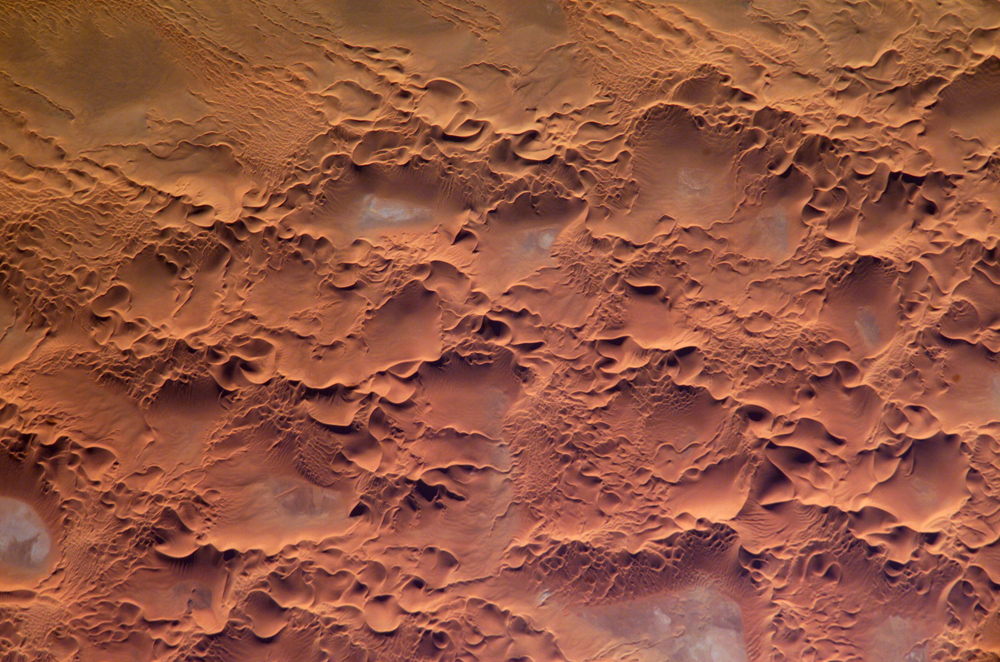
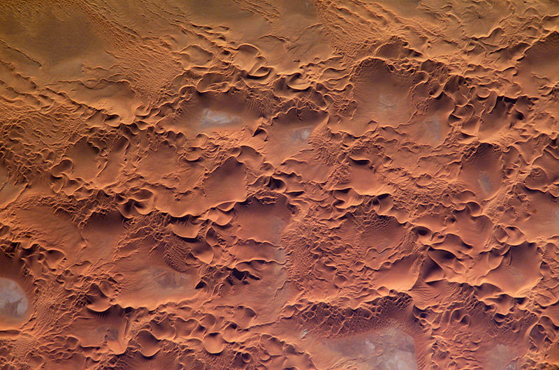
Dosiero:IssaouaneErg Algeria ISS010-E-13539.jpg
Bildo en pli alta difino ((1 000 × 662 rastrumeroj, grandeco de dosiero: 491 KB, MIME-tipo: image/jpeg))
| Jen dosiero de la Wikimedia-Komunejo. La priskribo en ties priskriba paĝo estas montrata suben.
|
Resumo
| Priskribo |
English: Astronaut photo of the Issaouane Erg (Sahara Desert), Algeria.
|
||||||||||||||||||||||||||||||||||||||||||||||||||||||
| Dato | |||||||||||||||||||||||||||||||||||||||||||||||||||||||
| Fonto | http://earthobservatory.nasa.gov/Newsroom/NewImages/images.php3?img_id=16813 | ||||||||||||||||||||||||||||||||||||||||||||||||||||||
| Aŭtoro | ISS Crew Earth Observations experiment and the Image Science & Analysis Group, Johnson Space Center. | ||||||||||||||||||||||||||||||||||||||||||||||||||||||
| Permeso (Reuzo de la dosiero) |
NASA, public domain | ||||||||||||||||||||||||||||||||||||||||||||||||||||||
Permesiloj:
This file is in the public domain in the United States because it was created by the Image Science & Analysis Laboratory, of the NASA Johnson Space Center. NASA copyright policy states that "NASA material is not protected by copyright unless noted". (NASA media use guidelines or Conditions of Use of Astronaut Photographs).
Photo source: ISS010-E-13539.
|
Dosierhistorio
Alklaku iun daton kaj horon por vidi kiel la dosiero tiam aspektis.
| Dato/Horo | Bildeto | Grandecoj | Uzanto | Komento | |
|---|---|---|---|---|---|
| nun | 17:58, 18 maj. 2006 | | 1 000 × 662 (491 KB) | Holly Cheng | ==Summary== {{Information | Description=Astronaut photo of the Issaouane Erg (Sahara Desert), Algeria. | Source=http://earthobservatory.nasa.gov/Newsroom/NewImages/images.php3?img_id=16813 | Date=January 16, 2005 | Author=ISS Crew Earth Observations exper |
Dosiera uzado
La jena paĝo ligas al ĉi tiu dosiero:
Suma uzado de la dosiero
La jenaj aliaj vikioj utiligas ĉi tiun dosieron:
- Uzado en ar.wikipedia.org
- Uzado en ba.wikipedia.org
- Uzado en be.wikipedia.org
- Uzado en bg.wikipedia.org
- Uzado en br.wikipedia.org
- Uzado en ceb.wikipedia.org
- Uzado en da.wikipedia.org
- Uzado en de.wikipedia.org
- Uzado en en.wikipedia.org
- Uzado en fi.wikipedia.org
- Uzado en fr.wikipedia.org
- Uzado en fr.wiktionary.org
- Uzado en hi.wikipedia.org
- Uzado en it.wikipedia.org
- Uzado en it.wikibooks.org
- Uzado en ka.wikipedia.org
- Uzado en lt.wikipedia.org
- Uzado en mhr.wikipedia.org
- Uzado en mk.wikipedia.org
- Uzado en nn.wikipedia.org
- Uzado en pl.wikipedia.org
- Uzado en pl.wiktionary.org
- Uzado en ro.wikipedia.org
- Uzado en ru.wikipedia.org
- Uzado en sl.wikipedia.org
- Uzado en sr.wikipedia.org
- Uzado en sv.wikipedia.org
- Uzado en sv.wiktionary.org
- Uzado en uk.wikipedia.org
- Uzado en uz.wikipedia.org
- Uzado en vi.wikipedia.org
- Uzado en www.wikidata.org