Dosiero:Spitsbergen labelled.png

Paĝenhavo ne ekzistas en aliaj lingvoj.
El Vikipedio, la libera enciklopedio

Spitsbergen_labelled.png((451 × 446 rastrumeroj, grandeco de dosiero: 161 KB, MIME-tipo: image/png))

Jen dosiero de la Wikimedia-Komunejo. La priskribo en ties priskriba paĝo estas montrata suben.
La Komunejo estas dosieruja retejo de libere licencitaj dosieroj.

Resumo

Priskribo
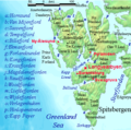
English: Map detailing the marine features of Spitsbergen in the Svalbard archipelago. Settlements and mountains are indicated and labelled. See also Image:Spitsbergen mountains and marine features labelled.png. Locations were labelled mainly based on detailed maps from svalbard-images.com (sample of south Spitsbergen linked), cross-referenced with other map sources where possible. Norwegian Polar Institute figures were used for mountain names and heights, which are given in meters above sea level.
Dato la 25-a de julio 2006 (origina alŝuta dato)
Fonto Nenia maŝinlegebla fonto disponigita. Oni supozas, ke estas propra verko, bazante sur kopirajtaj asertoj.
Aŭtoro Nenia maŝinlegebla fonto disponigita. Oni supozas, ke TheGrappler verkis ĝin, bazante sur kopirajtaj asertoj.

Permesiloj:

DEMIS World Map Server archive copy at the Wayback Machine generated this map from Public Domain sources. DEMIS does not claim any rights over the resultant image ([1] archive copy at the Wayback Machine). Alterations, including the addition of settlements and captions, were performed on 24 July 2006 by User:TheGrappler, the uploader, who releases all associated rights.

Public domain Mi, la posedanto de la aŭtorrajto por ĉi tiu verko, liberigas ĝin tutmonde kiel publikan havaĵon.
En iuj landoj tio povas esti laŭleĝe neebla; en tiu okazo:
Mi rajtigas ĉiun ajn uzi ĉi tiun verkon por ajna celo, sen iuj ajn kondiĉoj, krom se tiuj kondiĉoj estas postulataj per leĝo.
Public domain
This image is in the public domain because it came from the site https://www.demis.nl/products/web-map-server/examples/ and was released by the copyright holder. Permission is granted to copy, distribute and/or modify this map since it is based on free of copyright images from: www.demis.nl. See also approval email on de.wp and its clarification.

Deutsch | English | македонски | മലയാളം | Nederlands | slovenščina | +/−

Public domain This work has been released into the public domain by its copyright holder, www.demis.nl. This applies worldwide.
En iuj landoj tio povas esti laŭleĝe neebla; en tiu okazo:
www.demis.nl donas al iu ajn la rajton uzi ĉi tiun verkon por iu ajn uzo, sen kondiĉoj, krom se tiuj kondiĉoj deviĝas per leĝo.

Titoloj

Donu unulinian priskribon de la enhavo de ĉi tiu dosiero

Eroj prezentitaj en ĉi tiu dosiero

montras

Dosierhistorio

Alklaku iun daton kaj horon por vidi kiel la dosiero tiam aspektis.

Dato/HoroBildetoGrandecojUzantoKomento
nun09:23, 26 jul. 2006Bildeto por versio ekde 09:23, 26 jul. 2006451 × 446 (161 KB)TheGrapplerMore detail in South
00:58, 25 jul. 2006Bildeto por versio ekde 00:58, 25 jul. 2006451 × 446 (159 KB)TheGrapplerMove "Albert I Land" label slightly, to avoid obscuring Magdalenefjorden
00:46, 25 jul. 2006Bildeto por versio ekde 00:46, 25 jul. 2006451 × 446 (160 KB)TheGrappler== Summary == {{English}} Map detailing the marine features of Spitsbergen in the Svalbard archipelago. Settlements and mountains are indicated and labelled. See also Image:Spitsbergen mountains and marine features labelled.png. Locations were labell

La jenaj paĝoj ligas al ĉi tiu dosiero:

Suma uzado de la dosiero